File:Lombard state 526.png
Pāriet uz navigāciju
Pāriet uz meklēšanu

Šī priekšskata izmērs: 800 × 571 pikseļi. Citi izmēri: 320 × 228 pikseļi | 640 × 457 pikseļi | 986 × 704 pikseļi.
Sākotnējais fails (986 × 704 pikseļi, faila izmērs: 51 KB, MIME tips: image/png)
Captions
Captions
Pievieno vienas rindiņas aprakstu, ko šis fails attēlo
Kopsavilkums[labot šo sadaļu]
| Apraksts |
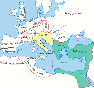
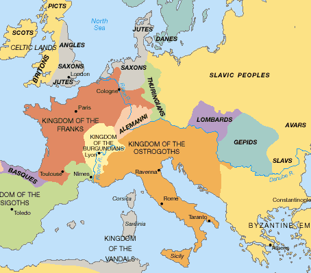
English: State of the Lombards in 526 AD. |
| Datums | |
| Avots | Paša darbs - based on: Stjepan Srkulj, Hrvatska povijest u devetnaest karata, Zagreb, 1937. (online version of map from this book: [1]) |
| Autors | PANONIAN |
| Citas versijas | Derivative works of this file: Lombard state 526.svg |
![[1]](http://www.dodaj.rs/f/3D/1D/4ZBxWIDO/teodvel.jpg)
Licence[labot šo sadaļu]
Es, šī darba autortiesību īpašnieks, publicēju to saskaņā ar šo licenci:
| This file is made available under the Creative Commons CC0 1.0 Universal Public Domain Dedication. | |
| The person who associated a work with this deed has dedicated the work to the public domain by waiving all of their rights to the work worldwide under copyright law, including all related and neighboring rights, to the extent allowed by law. You can copy, modify, distribute and perform the work, even for commercial purposes, all without asking permission.
|
References[labot šo sadaļu]
6th century borders are drawn in accordance with this source map:
- [2], [3] (Source map originating from this book: Stjepan Srkulj, Hrvatska povijest u devetnaest karata, Zagreb, 1937. [4])
![[2]](https://marinknezovic.files.wordpress.com/2016/10/teodvel.jpg)
References for modern borders and cities:
- http://www.lib.utexas.edu/maps/europe/slovakia_map.jpg
- http://www.lib.utexas.edu/maps/europe/romania_pol96.jpg
Other secondary references:
- Denis Šehić - Demir Šehić, Istorijski atlas sveta, Beograd, 2007.
- Istorijski atlas, Intersistem kartografija, Beograd, 2010.
- The Times History of Europe, Times Books, London, 2002.
- Dragan Brujić, Vodič kroz svet Vizantije, Beograd, 2004.
- Školski istorijski atlas, Zavod za izdavanje udžbenika SR Srbije, Beograd, 1970.
- http://rbedrosian.com/Maps/muhamm6b.jpg
- http://www.fordham.edu/halsall/maps/526eur.jpg
- http://www.euratlas.net/history/europe/500/index.html
- http://www.homolaicus.com/arte/ravenna/map3.gif
- http://www.worldmapsonline.com/UnivHist/30305_6.gif
- http://www.globalsecurity.org/military/world/europe/images/byz-map-526.jpg
- http://manofroma.files.wordpress.com/2010/05/barbarian-europe.gif?w=454&h=399
- Muir's Historical Atlas - Medieval and Modern (London, 1911) - File:Europe in 526.jpg
Faila hronoloģija
Uzklikšķini uz datums/laiks kolonnā esošās saites, lai apskatītos, kā šis fails izskatījās tad.
| Datums/Laiks | Attēls | Izmēri | Dalībnieks | Komentārs | |
|---|---|---|---|---|---|
| tagadējais | 2011. gada 20. oktobris, plkst. 19.08 | | 986 × 704 (51 KB) | PANONIAN (diskusija | devums) | {{Information |Description ={{en|1=State of the Lombards in 526 AD.}} |Source ={{own}} |Author =PANONIAN |Date =2011 |Permission = |other_versions = }} |
Šo failu nevar pārrakstīt.
Faila lietojums
Šo failu neizmanto nevienā lapā.
Globālais faila lietojums
Šīs Vikipēdijas izmanto šo failu:
- Izmantojums an.wikipedia.org
- Izmantojums ar.wikipedia.org
- Izmantojums de.wikipedia.org
- Izmantojums gl.wikipedia.org
- Izmantojums ja.wikipedia.org
- Izmantojums nl.wikipedia.org
- Izmantojums sh.wikipedia.org
- Izmantojums sr.wikipedia.org
- Izmantojums zh.wikipedia.org