File:Lombardy.satellite.jpg
ნავიგაციაზე გადასვლა
ძიებაზე გადასვლა

ზომა წინასწარი გადახედვისას: 600 × 600 პიქსელი. სხვა გაფართოება: 240 × 240 პიქსელი | 480 × 480 პიქსელი | 768 × 768 პიქსელი | 1 024 × 1 024 პიქსელი | 2 048 × 2 048 პიქსელი | 4 055 × 4 055 პიქსელი.
თავდაპირველი ფაილი (4 055 × 4 055 პიქსელი, ფაილის ზომა: 15,2 მბ, MIME ტიპი: image/jpeg)
Captions
Captions
Add a one-line explanation of what this file represents
რეზიუმე[რედაქტირება]
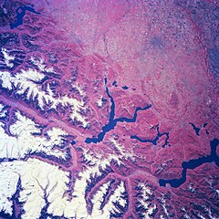
| აღწერა | Several elongated lakes (dark features) are identifiable in this southerly view of the Italian-Swiss border. The elongated lakes are the creation of alpine (or valley) glaciers that moved generally southward through this section of the Italian Alps over 12000 years ago. From west to east the four larger lakes are Maggiore (lower right corner), Lugana, Como, and d'Iseo (upper left corner). Smaller lakes (also dark features) are visible at the southern end of Lake Como (center of image) and Lake Maggiore. Subtle faults that are perpendicular to the southern end of the lakes can be traced east to west across the landscape at the base of the Italian Alps. Glaciated, U-shaped valleys are discernible north and northeast of the lakes. The color infrared helps to identify the densely vegetated mountain slopes where the forested land (green vegetation) is shown as concentrations of reddish patterns. The relatively flat plains of the highly industrialized and agriculturally productive Po River Valley (upper third of image) presents a dramatically different looking terrain than the snow covered mountainous region of northern Italy. |
| თარიღი | Winter/Spring 1997 |
| წყარო | Here |
| ავტორი | Image Science and Analysis Laboratory, NASA-Johnson Space Center. 18 Mar. 2005. "Earth from Space - Image Information." |
This image or video was catalogued by one of the centers of the United States National Aeronautics and Space Administration (NASA) under Photo ID: NM23-776-834. This tag does not indicate the copyright status of the attached work. A normal copyright tag is still required. See Commons:Licensing. Other languages:
|
ლიცენზია[რედაქტირება]
| This file is in the public domain in the United States because it was solely created by NASA. NASA copyright policy states that "NASA material is not protected by copyright unless noted". (See Template:PD-USGov, NASA copyright policy page or JPL Image Use Policy.) | ||
 |
Warnings:
|
ფაილის ისტორია
დააწკაპუნეთ თარიღზე/დროზე, რათა იხილოთ ფაილი, როგორც ის მაშინ გამოიყურებოდა.
| თარიღი/დრო | მინიატიურა | განზომილებები | მომხმარებელი | კომენტარი | |
|---|---|---|---|---|---|
| მიმდინარე | 21:18, 24 ივლისი 2023 | | 4 055 × 4 055 (15,2 მბ) | Don-vip (განხილვა | წვლილი) | |
| 19:05, 5 აგვისტო 2006 |  | 639 × 639 (391 კბ) | Lange~commonswiki (განხილვა | წვლილი) | {{Information |Description= Several elongated lakes (dark features) are identifiable in this southerly view of the Italian-Swiss border. The elongated lakes are the creation of alpine (or valley) glaciers that moved generally southward through this sectio |
თქვენ არ შეგიძლიათ ამ ფაილზე გადაწერა.
ფაილის გამოყენება
მომდევნო გვერდები იყენებენ ამ ფაილს:
- Lombardia
- Mountains of Lake Como
- File:Francesco Sforza.jpg
- File:Lille PdBA lombardie jean baptiste.jpg
- File:Scuola lombarda, ritratto di francesco sforza, 1480 ca. (brera) 01.jpg
- File:Scuola lombarda, ritratto di francesco sforza, 1480 ca. (brera) 02 manica.jpg
- Category:Abbeys in Lombardy
- Category:Archaeological sites in Lombardy
- Category:Architects from Lombardy
- Category:Association football clubs in Lombardy
- Category:Births in Lombardy
- Category:Bridges in Lombardy
- Category:Canals in Lombardy
- Category:Cemeteries in Lombardy
- Category:Culture of Lombardy
- Category:Deaths in Lombardy
- Category:Former railway lines in Lombardy
- Category:Hospitals in Lombardy
- Category:Lighthouses in Lombardy
- Category:Lombardy
- Category:Lombardy in the 20th century
- Category:Lombardy in the 21st century
- Category:Maps of Lombardy
- Category:Monasteries in Lombardy
- Category:Palaces in Lombardy
- Category:People of Lombardy
- Category:Provinces of Lombardy
- Category:Railway lines in Lombardy
- Category:Religion in Lombardy
- Category:Views of Lombardy
_01.jpg)
_02_manica.jpg)
ფაილის გლობალური გამოყენება
ეს ფაილი გამოიყენება შემდეგ ვიკებში:
- გამოყენება ar.wikipedia.org-ში
- გამოყენება arz.wikipedia.org-ში
- გამოყენება ast.wikipedia.org-ში
- გამოყენება az.wikipedia.org-ში
- გამოყენება bg.wikipedia.org-ში
- გამოყენება ca.wikipedia.org-ში
- გამოყენება cy.wikipedia.org-ში
- გამოყენება de.wikivoyage.org-ში
- გამოყენება diq.wikipedia.org-ში
- გამოყენება fi.wikipedia.org-ში
- გამოყენება fr.wikipedia.org-ში
- გამოყენება fr.wikivoyage.org-ში
- გამოყენება ga.wikipedia.org-ში
- გამოყენება gd.wikipedia.org-ში
- გამოყენება gl.wikipedia.org-ში
- გამოყენება he.wikipedia.org-ში
- გამოყენება hy.wikipedia.org-ში
- გამოყენება ia.wikipedia.org-ში
- გამოყენება id.wikipedia.org-ში
- გამოყენება ilo.wikipedia.org-ში
- გამოყენება it.wikipedia.org-ში
- გამოყენება ka.wikipedia.org-ში
- გამოყენება ku.wikipedia.org-ში
- გამოყენება la.wikipedia.org-ში
- გამოყენება mzn.wikipedia.org-ში
- გამოყენება nn.wikipedia.org-ში
- გამოყენება no.wikipedia.org-ში
- გამოყენება oc.wikipedia.org-ში
- გამოყენება pl.wikipedia.org-ში
- გამოყენება ro.wikipedia.org-ში
- გამოყენება ru.wikipedia.org-ში
- გამოყენება ru.wikinews.org-ში
- გამოყენება sl.wikipedia.org-ში
- გამოყენება sr.wikipedia.org-ში
- გამოყენება tt.wikipedia.org-ში
- გამოყენება uk.wikipedia.org-ში
- გამოყენება vec.wikipedia.org-ში
- გამოყენება vi.wikipedia.org-ში
- გამოყენება www.wikidata.org-ში
კატეგორიები:
- Satellite pictures of Lombardy
- Satellite pictures of the Alps
- Satellite pictures of Lake Como
- Satellite pictures of Lake Lugano
- Satellite pictures of Lake Maggiore
- Lake Iseo
- Lake Varese
- Maps of the Po watercourse system
- Aerial photographs of the canton of Ticino
- Earth photography from Mir
- False-color satellite images
- Color-infrared satellite pictures