File:Lombardy.satellite.jpg
Here nagîvasyonê
Here lêgerînê

Mezinahiya vê pêşdîtinê: 600 × 600 pîksel. Resolusyonên din: 240 × 240 pîksel | 480 × 480 pîksel | 768 × 768 pîksel | 1024 × 1024 pîksel | 2048 × 2048 pîksel | 4055 × 4055 pîksel.
Dosyeya orjînal (4055 × 4055 pixel, mezinbûnê data: 15,2 MB, MIME-typ: image/jpeg)
Captions
Captions
Add a one-line explanation of what this file represents
Danasîn[biguhêre]
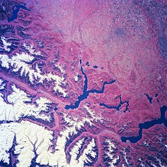
| Danasîn | Several elongated lakes (dark features) are identifiable in this southerly view of the Italian-Swiss border. The elongated lakes are the creation of alpine (or valley) glaciers that moved generally southward through this section of the Italian Alps over 12000 years ago. From west to east the four larger lakes are Maggiore (lower right corner), Lugana, Como, and d'Iseo (upper left corner). Smaller lakes (also dark features) are visible at the southern end of Lake Como (center of image) and Lake Maggiore. Subtle faults that are perpendicular to the southern end of the lakes can be traced east to west across the landscape at the base of the Italian Alps. Glaciated, U-shaped valleys are discernible north and northeast of the lakes. The color infrared helps to identify the densely vegetated mountain slopes where the forested land (green vegetation) is shown as concentrations of reddish patterns. The relatively flat plains of the highly industrialized and agriculturally productive Po River Valley (upper third of image) presents a dramatically different looking terrain than the snow covered mountainous region of northern Italy. |
| Dîrok | Winter/Spring 1997 |
| Çavkanî | Here |
| Xwedî | Image Science and Analysis Laboratory, NASA-Johnson Space Center. 18 Mar. 2005. "Earth from Space - Image Information." |
This image or video was catalogued by one of the centers of the United States National Aeronautics and Space Administration (NASA) under Photo ID: NM23-776-834. This tag does not indicate the copyright status of the attached work. A normal copyright tag is still required. See Commons:Licensing. Other languages:
|
Lîsans[biguhêre]
| This file is in the public domain in the United States because it was solely created by NASA. NASA copyright policy states that "NASA material is not protected by copyright unless noted". (See Template:PD-USGov, NASA copyright policy page or JPL Image Use Policy.) | ||
 |
Warnings:
|
Dîroka daneyê
Ji bo dîtina guhartoya wê demê bişkoka dîrokê bitikîne.
| Dîrok/Katjimêr | Wêneyê biçûk | Mezinahî | Bikarhêner | Şirove | |
|---|---|---|---|---|---|
| niha | 21:18, 24 tîrmeh 2023 | | 4055 x 4055 (15,2 MB) | Don-vip (gotûbêj | beşdarî) | |
| 19:05, 5 tebax 2006 |  | 639 x 639 (391 KB) | Lange~commonswiki (gotûbêj | beşdarî) | {{Information |Description= Several elongated lakes (dark features) are identifiable in this southerly view of the Italian-Swiss border. The elongated lakes are the creation of alpine (or valley) glaciers that moved generally southward through this sectio |
Tu nikarî cardin li ser vê dosyeyê binivîsînî.
Bikaranîna pelê
Ev 30 rûpel li jêr vê dosyeyê bi kar tînin:
- Lombardia
- Mountains of Lake Como
- File:Francesco Sforza.jpg
- File:Lille PdBA lombardie jean baptiste.jpg
- File:Scuola lombarda, ritratto di francesco sforza, 1480 ca. (brera) 01.jpg
- File:Scuola lombarda, ritratto di francesco sforza, 1480 ca. (brera) 02 manica.jpg
- Category:Abbeys in Lombardy
- Category:Archaeological sites in Lombardy
- Category:Architects from Lombardy
- Category:Association football clubs in Lombardy
- Category:Births in Lombardy
- Category:Bridges in Lombardy
- Category:Canals in Lombardy
- Category:Cemeteries in Lombardy
- Category:Culture of Lombardy
- Category:Deaths in Lombardy
- Category:Former railway lines in Lombardy
- Category:Hospitals in Lombardy
- Category:Lighthouses in Lombardy
- Category:Lombardy
- Category:Lombardy in the 20th century
- Category:Lombardy in the 21st century
- Category:Maps of Lombardy
- Category:Monasteries in Lombardy
- Category:Palaces in Lombardy
- Category:People of Lombardy
- Category:Provinces of Lombardy
- Category:Railway lines in Lombardy
- Category:Religion in Lombardy
- Category:Views of Lombardy
_01.jpg)
_02_manica.jpg)
Bikaranîna gerdûnî ya pelê
Ev wîkiyên di rêzê de vê pelê bi kar tînin:
- Bikaranîna di ar.wikipedia.org de
- Bikaranîna di arz.wikipedia.org de
- Bikaranîna di ast.wikipedia.org de
- Bikaranîna di az.wikipedia.org de
- Bikaranîna di bg.wikipedia.org de
- Bikaranîna di ca.wikipedia.org de
- Bikaranîna di cy.wikipedia.org de
- Bikaranîna di de.wikivoyage.org de
- Bikaranîna di diq.wikipedia.org de
- Bikaranîna di fi.wikipedia.org de
- Bikaranîna di fr.wikipedia.org de
- Bikaranîna di fr.wikivoyage.org de
- Bikaranîna di ga.wikipedia.org de
- Bikaranîna di gd.wikipedia.org de
- Bikaranîna di gl.wikipedia.org de
- Bikaranîna di he.wikipedia.org de
- Bikaranîna di hy.wikipedia.org de
- Bikaranîna di ia.wikipedia.org de
- Bikaranîna di id.wikipedia.org de
- Bikaranîna di ilo.wikipedia.org de
- Bikaranîna di it.wikipedia.org de
- Bikaranîna di ka.wikipedia.org de
- Bikaranîna di ku.wikipedia.org de
- Bikaranîna di la.wikipedia.org de
- Bikaranîna di mzn.wikipedia.org de
- Bikaranîna di nn.wikipedia.org de
- Bikaranîna di no.wikipedia.org de
- Bikaranîna di oc.wikipedia.org de
- Bikaranîna di pl.wikipedia.org de
- Bikaranîna di ro.wikipedia.org de
- Bikaranîna di ru.wikipedia.org de
- Bikaranîna di ru.wikinews.org de
- Bikaranîna di sl.wikipedia.org de
- Bikaranîna di sr.wikipedia.org de
- Bikaranîna di tt.wikipedia.org de
- Bikaranîna di uk.wikipedia.org de
- Bikaranîna di vec.wikipedia.org de
- Bikaranîna di vi.wikipedia.org de
- Bikaranîna di www.wikidata.org de
Kategorî:
- Satellite pictures of Lombardy
- Satellite pictures of the Alps
- Satellite pictures of Lake Como
- Satellite pictures of Lake Lugano
- Satellite pictures of Lake Maggiore
- Lake Iseo
- Lake Varese
- Maps of the Po watercourse system
- Aerial photographs of the canton of Ticino
- Earth photography from Mir
- False-color satellite images
- Color-infrared satellite pictures