File:Loring Moves Toward Fayetteville.png
Jump to navigation
Jump to search
Size of this preview: 640 × 600 pixels. Other resolutions: 256 × 240 pixels | 716 × 671 pixels.
Original file (716 × 671 pixels, file size: 1.09 MB, MIME type: image/png)
Captions
Captions
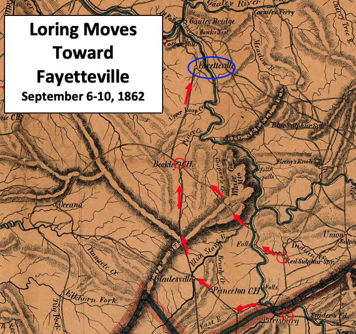
Loring moved toward Raleigh Court House (Beckley) in two columns
Summary
[edit]
| Description |
English: This map shows the September 6-10, 1862, movement of Confederate troops under the command of Major General William W. Loring in the American Civil War. |
| Date | |
| Source | This is a crop from a map of western Virginia as of 1864, with the border for West Virginia also displayed. The map has been altered by TwoScarsUp to add information on the September 6-10, 1862, Confederate troop movements for the command of Major General William W. Loring. Arrows and points circled are based on information provided in chapter 4 of the book "The Battle of Charleston and the 1862 Kanawha Valley Campaign" by Terry Lowry. The original map can be found at the U.S. Library of Congress here. |
| Author | W. L. Nicholson modified by TwoScarsUp |
Western Virginia and southern West Virginia, USA
Licensing
[edit]
|
This work is in the public domain in its country of origin and other countries and areas where the copyright term is the author's life plus 70 years or fewer. This work is in the public domain in the United States because it was published (or registered with the U.S. Copyright Office) before January 1, 1929. | |
| This file has been identified as being free of known restrictions under copyright law, including all related and neighboring rights. | |
File history
Click on a date/time to view the file as it appeared at that time.
| Date/Time | Thumbnail | Dimensions | User | Comment | |
|---|---|---|---|---|---|
| current | 21:25, 5 December 2022 | | 716 × 671 (1.09 MB) | TwoScarsUp (talk | contribs) | Uploaded a work by W. L. Nicholson modified by TwoScarsUp from This is a crop from a map of western Virginia as of 1864, with the border for West Virginia also displayed. The map has been altered by TwoScarsUp to add information on the September 6-10, 1862, Confederate troop movements for the command of Major General William W. Loring. Arrows and points circled are based on information provided in chapter 4 of the book "The Battle of Charleston and the 1862 Kanawha Valley Campaign" by Terry... |
You cannot overwrite this file.
File usage on Commons
There are no pages that use this file.
File usage on other wikis
The following other wikis use this file:
- Usage on en.wikipedia.org