File:M. Pikovsky, מפת ארץ ישראל (FL147392514 2369358) (cropped).jpg
Jump to navigation
Jump to search

Size of this preview: 349 × 599 pixels. Other resolutions: 140 × 240 pixels | 279 × 480 pixels | 447 × 768 pixels | 596 × 1,024 pixels | 2,125 × 3,647 pixels.
Original file (2,125 × 3,647 pixels, file size: 8.12 MB, MIME type: image/jpeg)
Captions
Captions
Add a one-line explanation of what this file represents
Summary
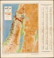
[edit]| Michael Pikovsky: Map of Palestine
|
||||||||||||||||||||||||
|---|---|---|---|---|---|---|---|---|---|---|---|---|---|---|---|---|---|---|---|---|---|---|---|---|
| Artist |
|
.jpg) | ||||||||||||||||||||||
| Title |
מפת ארץ ישראל |
|||||||||||||||||||||||
| Publisher | ||||||||||||||||||||||||
| Object type |
topographic map |
|||||||||||||||||||||||
| Genre |
map |
|||||||||||||||||||||||
| Description |
מפת ארץ ישראל. . . קלישאות: מ. פיקובסקי. |
|||||||||||||||||||||||
| Language |
Hebrew |
|||||||||||||||||||||||
| Publication date |
possibly |
|||||||||||||||||||||||
| Collection |
|
|||||||||||||||||||||||
| Current location |
|
|||||||||||||||||||||||
| Place of publication |
Jerusalem |
|||||||||||||||||||||||
| Notes | כלולה מפת הנגב בקנה מידה 1:750,000; אינדקס: רשימת הישובים העברים בארץ ישראל | |||||||||||||||||||||||
| scale | 1:500,000 ; 1:750,000 cm | |||||||||||||||||||||||
| IE PID | IE147392512 | |||||||||||||||||||||||
| Rosetta filename | FL147392514 | |||||||||||||||||||||||
| NNL item ID (P3959) | 990023693580205171 | |||||||||||||||||||||||
| search Merhav catalog | Hebrew, Michael Pikovsky, Jerusalem, Bureau Central | |||||||||||||||||||||||
| search Merhav catalog | קרן קימת לישראל. הלשכה הראשית | |||||||||||||||||||||||
| Source/Photographer |
|
|||||||||||||||||||||||
| Other versions | ||||||||||||||||||||||||
| Jpg / Tif version |
|
|||||||||||||||||||||||


_(cropped).jpg&action=edit§ion=1)
Licensing
[edit]_(cropped).jpg&action=edit§ion=2)
This UK artistic or literary work, of which the author is unknown and cannot be ascertained by reasonable enquiry, is in the public domain because it is one of the following:
|
 |
File history
Click on a date/time to view the file as it appeared at that time.
| Date/Time | Thumbnail | Dimensions | User | Comment | |
|---|---|---|---|---|---|
| current | 10:09, 26 July 2023 | | 2,125 × 3,647 (8.12 MB) | Geagea (talk | contribs) | File:M. Pikovsky, מפת ארץ ישראל (FL147392514 2369358).jpg cropped 86 % horizontally, 78 % vertically using CropTool with precise mode. |
You cannot overwrite this file.
File usage on Commons
The following 2 pages use this file:
_(cropped).jpg)
_(cropped).jpg&oldid=801485012)