File:MFDCcontrol.png
MFDCcontrol.png (543 × 506 пкс, размер файла: 183 КБ, MIME-тип: image/png)
Краткие подписи
Краткие подписи
Краткое описание[править]
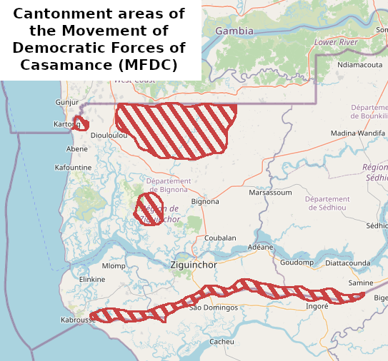
| Описание | Cantonment areas of the Movement of Democratic Forces of Casamance (MFDC), around 2017 |
| Дата | |
| Источник | Собственная работа, based on La frontière Sénégal-Gambie dans le contexte du conflit en Casamance : mobilités, flux transfrontaliers et géopolitique |
| Автор | User:Borysk5 |
| Описание |
Эта карта была создана из данных проекта OpenStreetMap, собранных сообществом. Данная карта может быть неполной и может содержать ошибки. Не следует при навигации полагаться исключительно на неё. |
|||
| Дата | (см. историю файла) | |||
| Источник | openstreetmap.org | |||
| Создатель |
Участники OpenStreetMap |
|||
| Права (Повторное использование этого файла) |
Данные OpenStreetMap распространяются по лицензии Open Database License (подробнее). Элементы карты распространяются по лицензии Creative Commons Attribution-ShareAlike 2.0 (CC-BY-SA 2.0).
Этот файл доступен по лицензии Creative Commons Attribution-Share Alike 2.0 Generic
|
|||
| Georeferencing | If inappropriate please set warp_status = skip to hide. |
История файла
Нажмите на дату/время, чтобы увидеть версию файла от того времени.
| Дата/время | Миниатюра | Размеры | Участник | Примечание | |
|---|---|---|---|---|---|
| текущий | 15:03, 10 июня 2022 | | 543 × 506 (183 КБ) | Borysk5 (обсуждение | вклад) | {{Information |Description=Cantonment areas of the Movement of Democratic Forces of Casamance (MFDC), around 2017 |Source={{own}}, based on [https://www.researchgate.net/figure/Forets-classees-et-zones-de-cantonnement-du-Mouvement-des-forces-democratiques-de-la_fig2_335528556 La frontière Sénégal-Gambie dans le contexte du conflit en Casamance : mobilités, flux transfrontaliers et géopolitique] |Date=2022-06-10 |Author=User:Borysk5 |Permission= |other_versions= }} {{OSM}} [[Category:Casam... |
Вы не можете перезаписать этот файл.
Использование файла
Более 100 страниц используют этот файл. В данном списке представлены только 100 страниц, использующих этот файл. Доступен также полный список.
- User:Hermes79
- User:Hermes7979
- File:2013 Hama Offensive.svg
- File:2015 Latakia Frontlines.svg
- File:Aleppo Offensives 2015.svg
- File:Armed conflict zones in Myanmar.png
- File:Attaques-terroristes-meurtrières-au-21eme-siecle.png
- File:Battle of Daraa City.svg
- File:Battle of Hasakah.svg
- File:Battle of Qamishli.svg
- File:Battle of Raqqa.svg
- File:Battle of Tadmur.svg
- File:Battle of Western Qalamoun.svg
- File:Battlefields in The Global War on Terror.svg
- File:Battlefields in The Global War on Terror - edit03.png
- File:Battlefields in The Global War on Terror - edit04.png
- File:Benghazi Conflict Detailed Map.png
- File:Benghazi Conflict Detailed Map.svg
- File:Boko Haram insurgency map.svg
- File:Countries by soldier count.svg
- File:Deir ez-Zor clashes (2017).svg
- File:East Congo conflict map.svg
- File:GSPC map.png
- File:ISIS (Grey) Territory Change 2014-2016.gif
- File:Iraqi Civil War map (2014–present).png
- File:Iraqi–Kurdish conflict map.png
- File:Islamist insurgency in Nigeria.svg
- File:Lebanese insurgency.png
- File:Lebanese insurgency.svg
- File:Libyan Civil War.svg
- File:Libyan war final-fr.svg
- File:Map of Ongoing conflicts around the world.png
- File:Map of terror of the Islamic State (ad-Daula al-islāmiyya).png
- File:Mexico states map small war.PNG
- File:Mosul offensive (2015) map.png
- File:Number of Terrorist Incidents.png
- File:Ongoing Conflicts (1).png
- File:Ongoing conflicts around the world.svg
- File:Pakistan-Waziristan-Map.png
- File:Political map Afar triangle.png
- File:Rif Damashq.svg
- File:Siege of Homs Map.svg
- File:Sinai insurgency.svg
- File:Somali Civil War (2009-present).svg
- File:Southern Sudan Civil War.svg
- File:Sudanese Internal Conflict.svg
- File:Syria and Iraq 2014-onward War map.png
- File:Syrian, Iraqi, and Lebanese insurgencies.png
- File:Syrian Civil War map.svg
- File:Syrian civil war.png
- File:Tadmur offensive (2015).jpg
- File:Territorial changes after 2016 Armenian-Azerbaijani clashes.jpg
- File:Turkish-PKK rebellion.svg
- File:War in North-West Pakistan.svg
- File:World2s.png
- File:Yemeni Civil War.svg
- File:Zones de conflit en Birmanie.png
- File:Саудовско-йеменский конфликт.png
- Template:Ongoing civil wars (maps)
- Category:2015 military intervention in Yemen
- Category:2016 Armenian–Azerbaijani clashes
- Category:Attack
- Category:Battle of Aleppo
- Category:Battles in 2016
- Category:Battles of Syria
- Category:Battles of the Syrian Civil War
- Category:Civil wars
- Category:Conflicts
- Category:Conflicts by continent
- Category:Conflicts by country
- Category:Conflicts by type
- Category:Current civil wars maps
- Category:Feuds
- Category:Fights
- Category:Liberation of Palmyra (2016)
- Category:Maps of Somali Civil War
- Category:Maps of conflicts
- Category:Maps of disputed territories
- Category:Maps of terrorism
- Category:Maps of the 2014 pro-Russian unrest in Ukraine
- Category:Maps of the Demilitarized Zone of Korea
- Category:Maps of the Syrian Civil War in 2016
- Category:Maps of the Syrian Civil War in 2017
- Category:Maps of the War in Afghanistan (2001–2021)
- Category:Maps of wars
- Category:Military conflicts
- Category:Military maps of the world
- Category:Ongoing armed conflicts
- Category:Palmyra offensive (December 2016)
- Category:Quarrels
- Category:Rebellions
- Category:Riots
- Category:Schisms
- Category:Syrian Civil War
- Category:Terrorism
- Category:Uprisings
- Category:War
- Category:War casualties
- Category:Warfare by type
- Category:Wars
.svg)
_Territory_Change_2014-2016.gif)
.png)
.png)
_map.png)
.png)
.svg)
.jpg)
Просмотреть остальные ссылки на этот файл.
Глобальное использование файла
Данный файл используется в следующих вики:
- Использование в en.wikipedia.org
- Использование в hu.wikipedia.org