File:MGS MOC Wide Angle Map of Mars PIA03467.jpg

原始檔案 (2,000 × 1,288 像素,檔案大小:534 KB,MIME 類型:image/jpeg)
說明
說明
摘要
[編輯]
| 描述 |
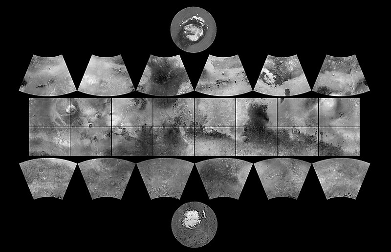
English: The MGS MOC Wide Angle Map of Mars
In 1979, NASA published ATLAS OF MARS: THE 1:5,000,000 MAP SERIES, edited by R.M. Batson, P.M. Bridges, and J.L. Inge, of the U.S. Geological Survey in Flagstaff, Arizona. This was a compendium of airbrushed shaded relief maps, controlled photomosaics, and in a few cases albedo (shading) maps, mostly assembled from Mariner 9 survey images, with some gaps filled by Viking orbiter images. The planet was divided into thirty "quadrangles" or areas, each with an "Mars Chart" or "MC" number (MC-1 through MC-30). The equatorial region was portrayed in the Mercator projection, with Lambert Conformal Conic for the mid-latitudes and Polar Stereographic for the poles. Although digital products such as the Mars Digital Image Mosaic (MDIM) and various Mars Global Surveyor (MGS) Mars Orbiter Laser Altimeter (MOLA) maps have partially supplanted the ATLAS, it remains a standard desktop reference today. In 1999, the Mars Orbiter Camera (MOC) aboard the MGS orbiter acquired a global stereo image dataset using its red-filter Wide Angle Camera. We have recently completed a 256 pixel/degree (about 230 meters/pixel) mosaic of these images using software developed at Malin Space Science Systems(MSSS). Visit the MSSS Geodesy Campaign Mosaic Page to access both partial and full-resolution mosaics in Planetary Data System format. The image above is a reproduction of the new MGS MOC Mars Digital Map and is the first of several cartographic products that MSSS expects to release this year. Malin Space Science Systems and the California Institute of Technology built the MOC using spare hardware from the Mars Observer mission. MSSS operates the camera from its facilities in San Diego, CA. The Jet Propulsion Laboratory's Mars Surveyor Operations Project operates the Mars Global Surveyor spacecraft with its industrial partner, Lockheed Martin Astronautics, from facilities in Pasadena, CA and Denver, CO. |
| 日期 | (addition date) |
| 來源 | http://photojournal.jpl.nasa.gov/catalog/PIA03467 (image link) |
| 作者 | NASA/JPL/MSSS |
| 此標籤不表示文件的著作權狀態。任何文件在附有此標籤的同時還需要一個有效的著作權標籤。請參閱許可協議說明頁面以了解更多資訊。 其他語言:
|
授權條款
[編輯]
| 本作品由NASA創作,屬於公有領域。根據NASA的版權政策:“NASA的創作除非另有聲明否則不受版權保護。”(參見:Template:PD-USGov/zh,NASA版權政策或JPL圖像使用政策) | ||
 |
警告:
|
| 註解 | 該圖片含有註解:在維基媒體共享資源上查看註解 |
檔案歷史
點選日期/時間以檢視該時間的檔案版本。
| 日期/時間 | 縮圖 | 尺寸 | 用戶 | 備註 | |
|---|---|---|---|---|---|
| 目前 | 2019年2月18日 (一) 10:19 | | 2,000 × 1,288(534 KB) | Kesäperuna(對話 | 貢獻) | 100% JPEG quality from full quality TIFF. (Upload preceding this was 90% JPEG) |
| 2019年2月18日 (一) 09:54 |  | 2,000 × 1,288(473 KB) | Kesäperuna(對話 | 貢獻) | 100% JPEG quality from full quality TIFF. | |
| 2008年4月12日 (六) 07:27 |  | 2,000 × 1,288(212 KB) | Bryan Derksen(對話 | 貢獻) | {{Information |Description={{en|In 1999, the Mars Orbiter Camera (MOC) aboard the MGS orbiter acquired a global stereo image dataset using its red-filter Wide Angle Camera. We have recently completed a 256 pixel/degree (about 230 meters/pixel) mosaic of t |
無法覆蓋此檔案。
檔案用途
下列34個頁面有用到此檔案:
- Commons:WikiProject Aviation/recent uploads/2019 February 18
- Template:Mars quadrangles
- Category:Aeolis quadrangle
- Category:Amazonis quadrangle
- Category:Amenthes quadrangle
- Category:Arabia quadrangle
- Category:Arcadia quadrangle
- Category:Argyre quadrangle
- Category:Casius quadrangle
- Category:Cebrenia quadrangle
- Category:Coprates quadrangle
- Category:Diacria quadrangle
- Category:Elysium quadrangle
- Category:Eridania quadrangle
- Category:Hellas quadrangle
- Category:Iapygia quadrangle
- Category:Ismenius Lacus quadrangle
- Category:Lunae Palus quadrangle
- Category:Mare Acidalium quadrangle
- Category:Mare Australe quadrangle
- Category:Mare Boreum quadrangle
- Category:Mare Tyrrhenum quadrangle
- Category:Margaritifer Sinus quadrangle
- Category:Memnonia quadrangle
- Category:Noachis quadrangle
- Category:Oxia Palus quadrangle
- Category:Phaethontis quadrangle
- Category:Phoenicis Lacus quadrangle
- Category:Quadrangles of Mars
- Category:Sinus Sabaeus quadrangle
- Category:Surface features of Mars by quadrangle
- Category:Syrtis Major quadrangle
- Category:Tharsis quadrangle
- Category:Thaumasia quadrangle
全域檔案使用狀況
以下其他 wiki 使用了這個檔案:
- ar.wikipedia.org 的使用狀況
- az.wikipedia.org 的使用狀況
- bs.wikipedia.org 的使用狀況
- ca.wikipedia.org 的使用狀況
- Exploració de Mart
- Cartografia de Mart
- Categoria:Quadrangles de Mart
- Categoria:Quadrangle Mare Boreum
- Categoria:Quadrangle Mare Acidalium
- Categoria:Quadrangle Diacria
- Categoria:Quadrangle Aeolis
- Categoria:Quadrangle Elysium
- Categoria:Quadrangle Ismenius Lacus
- Categoria:Quadrangle Cebrenia
- Categoria:Quadrangle Tharsis
- Categoria:Quadrangle Lunae Palus
- Categoria:Quadrangle Syrtis Major
- Categoria:Quadrangle Oxia Palus
- Categoria:Quadrangle Arabia
- Categoria:Quadrangle Amenthes
- Categoria:Quadrangle Memnonia
- Categoria:Quadrangle Phoenicis Lacus
- Categoria:Quadrangle Margaritifer Sinus
- Categoria:Quadrangle Sinus Sabaeus
- Categoria:Quadrangle Phaethontis
- Categoria:Quadrangle Thaumasia
- Categoria:Quadrangle Argyre
- Categoria:Quadrangle Noachis
- Categoria:Quadrangle Hellas
- Categoria:Quadrangle Mare Australe
- Categoria:Quadrangle Eridania
- Categoria:Quadrangle Arcadia
- Categoria:Quadrangle Casius
- Categoria:Quadrangle Coprates
- Categoria:Quadrangle Amazonis
- Plantilla:Quadrangles de Mart
- Categoria:Quadrangle Iapygia
- Categoria:Quadrangle Mare Tyrrhenum
- de.wikipedia.org 的使用狀況
檢視此檔案的更多全域使用狀況。