File:MH370 search March through October 2014.svg

Original file (SVG file, nominally 5,020 × 4,387 pixels, file size: 8.55 MB)
Captions
Captions
Summary[edit]
| Description |
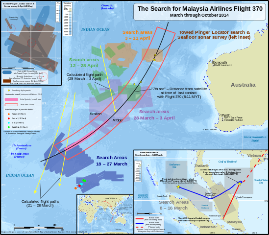
Map of search areas for Malaysia Airlines Flight 370 from the day of its disappearance through May 2014 and the planned search areas for the underwater phase of the search which began in the beginning of October 2014 and is planned to last up to one year (ending, of course, if the plane is found). (English version)
|
| Date | |
| Source |
Own work The following sources were used for data included in the map. Locations (eg. where the search was conducted, locations of satellite debris & acoustic detections) are factual information which cannot be copyrighted, although most sources are noted in the map. Main map:
Towed Pinger Locator path & seafloor sonar survey location:
Initial search areas:
Overview inset:
Backgrounds:
|
| Author | Andrew Heneen |
| Permission (Reusing this file) |
I, the copyright holder of this work, hereby publish it under the following license: This file is licensed under the Creative Commons Attribution-Share Alike 3.0 Unported license.
I, the copyright holder of this work, hereby publish it under the following license: This file is licensed under the Creative Commons Attribution 3.0 Unported license.
|
| Other versions |
|
| SVG development |


_zh.svg)
File history
Click on a date/time to view the file as it appeared at that time.
| Date/Time | Thumbnail | Dimensions | User | Comment | |
|---|---|---|---|---|---|
| current | 21:47, 9 November 2014 | | 5,020 × 4,387 (8.55 MB) | AHeneen (talk | contribs) | User created page with UploadWizard |
You cannot overwrite this file.
File usage on Commons
The following 11 pages use this file:
- Malaysia Airlines Flight 370
- Commons:Graphic Lab/Map workshop/Archive/2015
- Commons:WikiProject Aviation/recent uploads/2014 November 9
- File:MH370 SIO search.png
- File:MH370 SIO search through Nov 2014.svg
- File:MH370 TPL search and sonar survey.svg
- File:MH370 initial search Southeast Asia.svg
- File:MH370 search March through October 2014.svg
- File:The Search for Malaysia Airlines Flight 370 (March through October 2014) zh.svg
- File:The Search for Malaysia Airlines Flight 370 - Initial search areas (Southeast Asia) de.svg
- File:The Search for Malaysia Airlines Flight 370 - Initial search areas (Southeast Asia) zh.svg
_de.svg)
_zh.svg)
File usage on other wikis
The following other wikis use this file:
- Usage on en.wikipedia.org