File:MODIS Map.jpg
跳转到导航
跳转到搜索

本预览的尺寸:800 × 400像素。 其他分辨率:320 × 160像素 | 640 × 320像素 | 1,024 × 512像素 | 1,280 × 640像素 | 2,560 × 1,280像素 | 5,400 × 2,700像素。
原始文件 (5,400 × 2,700像素,文件大小:11.84 MB,MIME类型:image/jpeg)
说明
说明
添加一行文字以描述该文件所表现的内容
|

本图像被选为2010年5月21日的今日图片。其说明如下: English: Image based largely on observations from MODIS. 其他语言:
Čeština: Mapa světa složená zejména ze snímků přístrojem MODIS Dansk: Billede primært dannet af observationer fra et spektroradiometer om bord på Terra-satellitten. Deutsch: Bild der Erde, zusammengesetzt aus vielen Einzelbildern, überwiegend vom Moderate-resolution Imaging Spectroradiometer English: Image based largely on observations from MODIS. Español: Imagen basada en gran parte en observaciones desde el MODIS. Français : Image basée en grande partie sur des observations avec un MODIS. Italiano: Una foto satellitare della superficie terrestre, elaborata, in larga parte, dalle immagini fornite dalle fotocamere MODIS che equipaggiano i satelliti per telerilevamento Aqua (EOS PM-1) e Terra (EOS AM-1) Magyar: A földfelszín MODIS (közepes felbontású képalkotó spektrométer) technológiával készített vetületi képe Nederlands: Satellietbeeld van de Aarde, grotendeels samengesteld uit beelden van MODIS-camera's, gemonteerd op de Amerikaanse observatiesatellieten Terra (EOS AM-1) en Aqua (EOS PM-1). Polski: Obraz powierzchni i atmosfery Ziemi oparty głównie na zdjęciach z przyrządów MODIS satelitów Aqua i Terra. Македонски: Снимка заснована на набљудувањата на сателитскиот инструмент MODIS. Русский: Спутниковый снимок, сделанный камерой MODIS Українська: Зображення поверхні і атмосфери Землі створене переважно зі знімків з супутника НАСА з допомогою спектрорадіометра MODIS 11 червня 2005 року. বাংলা : নাসার মোডিসের পর্যবেক্ষণের মাধ্যমে তৈরিকৃত পৃথিবীর ছবি। 한국어: MODIS의 위성 사진을 합성한 지도. 日本語: 地球全体の衛星写真。MODISの観測を元にしたもの。ただし一部MODISがカバーしない箇所は別のデータを利用している。 中文: 中分辨率成像光谱仪拍摄的照片 中文(繁體): 中解析度成像光譜儀拍攝的地球照片 |
摘要[编辑]
| 描述 |
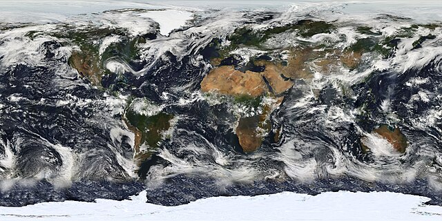
English: This image is based largely on observations from the Moderate Resolution Imaging Spectroradiometer (MODIS) - a sensor aboard the Terra satellite - on July 11, 2005. Small gaps in MODIS' coverage between overpasses, as well as Antarctica (which is in polar darkness in July), have been filled in using GOES weather satellites and the latest version of the NASA Blue Marble. Hurricane Dennis can be seen moving inland over the Gulf Coast.
Français : Planisphère montrant la terre telle qu'elle a été observée par le satellite MODIS le 11 juillet 2005. Les petits trous dans la couveture de MODIS ont été comblés avec des données provenant des satellites GOES, et la dernière version de la Blue marble (bille bleue) de la NASA.
Italiano: Una foto satellitare della superficie terrestre, elaborata, in larga parte, dalle immagini fornite dalle fotocamere MODIS che equipaggiano i satelliti per telerilevamento Aqua (EOS PM-1) e Terra (EOS AM-1).
Русский: Изображение, созданное главным образом по данным сканирующего спутникового спектрорадиометра MODIS (2005-07-11.) Небольшие «пропуски» между покрытиями прибора, а также Антарктика, были восстановлены с использованием данных метеоспутников GOES и последней версии «голубого мрамора» NASA. |
| 日期 | 摄于2005年7月11日 |
| 来源 | Earth's Vital Signs |
| 作者 | NASA |
| 其他版本 |
|


许可协议[编辑]
| 本文件完全由NASA创作,在美国属于公有领域。根据NASA的版权方针,NASA的材料除非另有声明否则不受版权保护。(参见Template:PD-USGov/zh、NASA版权方针页面或JPL图片使用方针。) | ||
 |
警告:
|
文件历史
点击某个日期/时间查看对应时刻的文件。
| 日期/时间 | 缩略图 | 大小 | 用户 | 备注 | |
|---|---|---|---|---|---|
| 当前 | 2010年2月25日 (四) 10:47 | | 5,400 × 2,700(11.84 MB) | Originalwana(留言 | 贡献) | {{Information |Description={{en|1=Image based largely on observations from the Moderate Resolution Imaging Spectroradiometer (MODIS). Small gaps in MODIS’ coverage between overpasses, as well as Antarctica, have been filled in using [[:Category:Geos |
您不可以覆盖此文件。
文件用途
以下57个页面使用本文件:
- Featured Photographs in the Public Domain
- User:Originalwana
- User:Ö/Best/2010
- Commons:Featured picture candidates/File:MODIS Map.jpg
- Commons:Featured picture candidates/Log/March 2010
- Commons:Featured pictures/Places/Satellite images
- Commons:Featured pictures/chronological/2010-A
- Commons:Picture of the Year/2010/Galleries/2010-A
- Commons:Picture of the Year/2010/Galleries/All
- Commons:Picture of the Year/2010/Galleries/Astronomy
- Commons:Picture of the Year/2010/Galleries/Astronomy/Large
- Commons:Picture of the Year/2010/Galleries/Astronomy/Small
- Commons:Picture of the Year/2010/Galleries/Index/3
- Commons:Picture of the Year/2010/Galleries/Index/Astronomy
- Commons:Picture of the Year/2010/Galleries/Table
- Commons:Picture of the Year/2010/Galleries/Table/03
- Commons:Picture of the Year/2010/R1/File:MODIS Map.jpg
- Commons:Picture of the Year/2010/Results/R1/ALL/Table
- Commons:Picture of the Year/2010/Results/R1/Astronomy
- Commons:Picture of the Year/2010/Results/R1/Astronomy/Table
- Commons:Potd/2010-05 (da)
- Commons:Potd/2010-05 (de)
- Commons:Potd/2010-05 (nl)
- Commons:Potd/2010-05 (pt)
- Commons talk:Picture of the Year/2010/Galleries/Table
- Commons talk:Picture of the Year/2010/Results/R1/ALL/Table
- File:Blue Marble 2002.jpg
- File:Blue Marble 2002.png
- File:Cours sur le Wiktionnaire francophone.pdf
- File:Cours sur le Wiktionnaire francophones 2024.pdf
- File:Define Wiktionary itWikiCon 2018.pdf
- File:Solar system bodies rotation animation.svg
- File:Wiktionnaire Atelier formation 2019.pdf
- File:Wiktionnaire Conf Mundolingua 2017.pdf
- File:Wiktionnaire Jeudis du libre Lyon 2018.pdf
- File:Wiktionnaire Wikiconvention 2018.pdf
- Template:Potd/2010-05
- Template:Potd/2010-05-21
- Template:Potd/2010-05-21 (bn)
- Template:Potd/2010-05-21 (cs)
- Template:Potd/2010-05-21 (da)
- Template:Potd/2010-05-21 (de)
- Template:Potd/2010-05-21 (en)
- Template:Potd/2010-05-21 (es)
- Template:Potd/2010-05-21 (fr)
- Template:Potd/2010-05-21 (hu)
- Template:Potd/2010-05-21 (it)
- Template:Potd/2010-05-21 (ja)
- Template:Potd/2010-05-21 (ko)
- Template:Potd/2010-05-21 (mk)
- Template:Potd/2010-05-21 (nl)
- Template:Potd/2010-05-21 (pl)
- Template:Potd/2010-05-21 (ru)
- Template:Potd/2010-05-21 (uk)
- Template:Potd/2010-05-21 (zh-hans)
- Template:Potd/2010-05-21 (zh-hant)
- Template:Potd/2010-05 (zh-hans)
全域文件用途
以下其他wiki使用此文件:
- af.wikipedia.org上的用途
- ar.wikipedia.org上的用途
- ba.wikipedia.org上的用途
- be.wikipedia.org上的用途
- bh.wikipedia.org上的用途
- bn.wikipedia.org上的用途
- bn.wikibooks.org上的用途
- ca.wikipedia.org上的用途
- crh.wikipedia.org上的用途
- cs.wikipedia.org上的用途
- cv.wikipedia.org上的用途
- en.wikipedia.org上的用途
- Cloud cover
- Moderate Resolution Imaging Spectroradiometer
- User talk:Nauticashades
- Talk:Cloud cover
- Wikipedia:Featured pictures/Space/Looking back
- Wikipedia:Featured pictures thumbs/23
- Wikipedia:Featured picture candidates/June-2010
- Wikipedia:Featured picture candidates/MODIS Cloud Cover Map
- Wikipedia:Wikipedia Signpost/2010-06-14/Features and admins
- Portal:Climate change/Selected picture
- Portal:Climate change/Selected picture/12
- Wikipedia:Picture of the day/January 2012
- Template:POTD/2012-01-01
- Wikipedia:Main Page history/2012 January 1
- User:AvionArchon/sandbox
- Wikipedia:Wikipedia Signpost/Single/2010-06-14
- User:Darth Tacker/TWA/Earth
- User:CheChe/Spoken Script
- User:Zanygenius/TWA/Earth
- User:Zanygenius/TWA/Earth/2
- User:Google7722/TWA/Earth
- es.wikipedia.org上的用途
- et.wikipedia.org上的用途
- eu.wikipedia.org上的用途
- fa.wikipedia.org上的用途
- fa.wikibooks.org上的用途
- fi.wikipedia.org上的用途
查看本文件的更多全域用途。