File:MOUTMARKA Tjøme Norway Færder nasjonalpark Friluftsområde turstier svaberg vårskog strender Recreational hiking area National park Coastal landscape Tønsbergfjorden Oslofjorden Utsikt View Østerøya Distorted forvrengt panorama.jpg
Jump to navigation
Jump to search

Size of this preview: 800 × 181 pixels. Other resolutions: 320 × 72 pixels | 640 × 145 pixels | 1,024 × 231 pixels | 1,280 × 289 pixels | 2,560 × 578 pixels | 15,051 × 3,400 pixels.
Original file (15,051 × 3,400 pixels, file size: 20.08 MB, MIME type: image/jpeg)
Captions
Captions
Add a one-line explanation of what this file represents
Summary
[edit]
| Description |
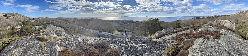
English: Distorted panoramic photo taken on a sunny spring afternoon in April 2021 at the Moutmarka recreational area, a part of Færder National Park on the island of Tjøme on the west side of the Oslo Fjord, Norway. View of the coastal landscape towards the outer part of Tønsbergfjorden and Østerøya etc. in the far west, with trees in the small forest, scattered vegetation, hiking trails and foot paths, glacial eroded hills and smooth slopes of bare rocks, boulders, cobbles and pebbles by the seashore, etc.
Norsk bokmål: Forvrengt panoramafoto fra Moutmarka friluftsområde, en del av Færder nasjonalpark sørvest øya Tjøme på vestsida av Ytre Oslofjord. Bildet er tatt en solfylt vårettermiddag i april 2021 og viser blant annet:
|
| Date | |
| Source | Own work |
| Author | Wolfmann |
Licensing
[edit]
I, the copyright holder of this work, hereby publish it under the following license:
This file is licensed under the Creative Commons Attribution-Share Alike 4.0 International license.
- You are free:
- to share – to copy, distribute and transmit the work
- to remix – to adapt the work
- Under the following conditions:
- attribution – You must give appropriate credit, provide a link to the license, and indicate if changes were made. You may do so in any reasonable manner, but not in any way that suggests the licensor endorses you or your use.
- share alike – If you remix, transform, or build upon the material, you must distribute your contributions under the same or compatible license as the original.
File history
Click on a date/time to view the file as it appeared at that time.
| Date/Time | Thumbnail | Dimensions | User | Comment | |
|---|---|---|---|---|---|
| current | 14:48, 25 April 2021 | 15,051 × 3,400 (20.08 MB) | Wolfmann (talk | contribs) | Uploaded own work with UploadWizard |
You cannot overwrite this file.
File usage on Commons
There are no pages that use this file.
File usage on other wikis
The following other wikis use this file:
- Usage on fr.wikipedia.org
- Usage on no.wikipedia.org