File:MSP Airport Diagram.pdf
Spring til navigation
Spring til søgning

Size of this JPG preview of this PDF file: 390 × 599 pixels. Andre opløsninger: 156 × 240 pixels | 313 × 480 pixels | 806 × 1.237 pixels.
Oprindelig fil (806 × 1.237 billedpunkter, filstørrelse: 351 KB, MIME-type: application/pdf)
Captions
Captions
Tilføj en kort forklaring på en enkelt linje om hvad filen viser
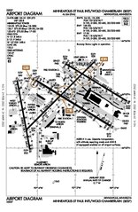
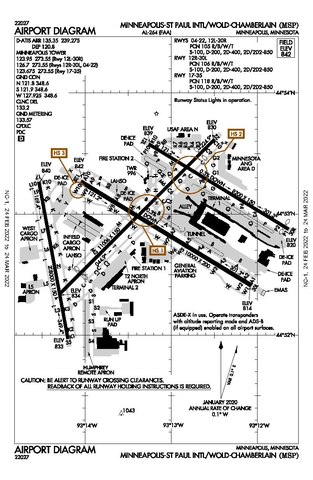
Airport Diagram of MSP Airport
Beskrivelse
[redigér]| Beskrivelse |
English: Diagram of MSP Airport |
| Dato | |
| Kilde | faa.gov/air_traffic/flight_info/aeronav/digital_products/dtpp/search/results/ |
| Forfatter | Federal Aviation Administration |
Licensering
[redigér]This image or file is a work of a Federal Aviation Administration employee, taken or made as part of that person's official duties. As a work of the U.S. federal government, the image is in the public domain in the United States.
|
 |
Filhistorik
Klik på en dato/tid for at se filen som den så ud på det tidspunkt.
| Dato/tid | Miniaturebillede | Dimensioner | Bruger | Kommentar | |
|---|---|---|---|---|---|
| nuværende | 12. mar. 2022, 18:13 |  | 806 × 1.237 (351 KB) | Randoperson1 (diskussion | bidrag) | Higher Quality |
| 18. feb. 2020, 19:19 |  | 806 × 1.237 (328 KB) | Sam.gov (diskussion | bidrag) | User created page with UploadWizard |
Du kan ikke overskrive denne fil.
Filanvendelse
De følgende 3 sider bruger denne fil:
Global filanvendelse
Følgende andre wikier anvender denne fil:
- Anvendelser på af.wikipedia.org
- Anvendelser på bn.wikipedia.org
- Anvendelser på en.wikipedia.org
- Anvendelser på es.wikipedia.org
- Anvendelser på he.wikipedia.org
- Anvendelser på simple.wikipedia.org