File:MS TN 2008 Tornado track map.png
Jump to navigation
Jump to search

Size of this preview: 608 × 599 pixels. Other resolutions: 244 × 240 pixels | 487 × 480 pixels | 886 × 873 pixels.
Original file (886 × 873 pixels, file size: 61 KB, MIME type: image/png)
Captions
Captions
Add a one-line explanation of what this file represents
Summary
[edit]
| Description |
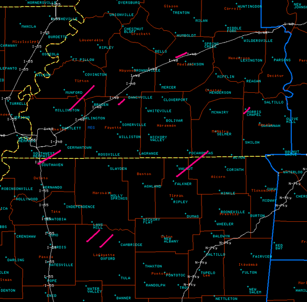
English: 2008 Mississippi/Tennessee tornado track map |
| Date | |
| Source | National Weather Service Memphis |
| Author | National Weather Service Memphis office |
| Permission (Reusing this file) |
PD-USGOV-NOAA |
Licensing
[edit]
This image is in the public domain because it contains materials that originally came from the U.S. National Oceanic and Atmospheric Administration, taken or made as part of an employee's official duties.
|
Original upload log
[edit]
The original description page was here. All following user names refer to en.wikipedia.
- 2008-02-08 04:07 Allstarecho 886×873×8 (62755 bytes) {{Information |Description=2008 Mississippi/Tennessee tornado track map |Source=National Weather Service |Date=02-07-2007 |Location=http://www.srh.noaa.gov/meg/events/20080205/graphics/prelim_tracks.png |Author=National Weather Service Memphis office |Per
File history
Click on a date/time to view the file as it appeared at that time.
| Date/Time | Thumbnail | Dimensions | User | Comment | |
|---|---|---|---|---|---|
| current | 16:02, 10 February 2008 | | 886 × 873 (61 KB) | Mattflaschen (talk | contribs) | {{Information |Description={{en|2008 Mississippi/Tennessee tornado track map}} |Source=[http://www.srh.noaa.gov/meg/events/20080205/graphics/prelim_tracks.png National Weather Service Memphis] |Date=2008-02-07 |Author=National Weather Service Memphis offi |
You cannot overwrite this file.
File usage on Commons
There are no pages that use this file.