File:MUKAISHIMA Island 1964.jpg
Jump to navigation
Jump to search

Size of this preview: 800 × 580 pixels. Other resolutions: 320 × 232 pixels | 640 × 464 pixels | 1,024 × 743 pixels | 1,280 × 929 pixels | 2,560 × 1,857 pixels | 3,992 × 2,896 pixels.
Original file (3,992 × 2,896 pixels, file size: 2.58 MB, MIME type: image/jpeg)
Captions
Captions
Add a one-line explanation of what this file represents
Summary[edit]
| Description |
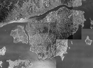
日本語: 1964年広島県の向島。 |
| Date | |
| Source |
|
| Author | 国土地理院 |
Licensing[edit]

|
The copyright holder of this file, the Ministry of Land, Infrastructure, Transport and Tourism of Japan, allows anyone to use it for any purpose, provided that the copyright holder is properly attributed. Redistribution, derivative work, commercial use, and all other use is permitted. |
Attribution:
Copyright © National Land Image Information (Color Aerial Photographs), Ministry of Land, Infrastructure, Transport and Tourism
|
 |
This image is copyrighted by the Ministry of Land, Infrastructure, Transport and Tourism of Japan. For terms of use, see the stipulation to use of National Land Information (in Japanese) and message from MLIT (in Japanese and English). When you display this image on an article, include the following phrase in the description: "Made based on National Land Image Information (Color Aerial Photographs), Ministry of Land, Infrastructure, Transport and Tourism".
|
File history
Click on a date/time to view the file as it appeared at that time.
| Date/Time | Thumbnail | Dimensions | User | Comment | |
|---|---|---|---|---|---|
| current | 19:10, 4 April 2016 | | 3,992 × 2,896 (2.58 MB) | M9106TB (talk | contribs) | {{Information |Description={{ja|1=1964年広島県の向島。}} |Source=[http://mapps.gsi.go.jp/maplibSearch.do 国土地理院・地図空中写真閲覧サービス] * CG6410Y-C5A-14 * CG6410Y-C5A-15 * CG6410Y-C6-15 * CG6410Y-C6-17 |Date=1964 |Locat... |
You cannot overwrite this file.
File usage on Commons
There are no pages that use this file.