File:Mackinac Island topographic map-en.svg
跳至導覽
跳至搜尋

此 SVG 檔案的 PNG 預覽的大小:545 × 600 像素。 其他解析度:218 × 240 像素 | 436 × 480 像素 | 698 × 768 像素 | 931 × 1,024 像素 | 1,862 × 2,048 像素 | 1,200 × 1,320 像素。
原始檔案 (SVG 檔案,表面大小:1,200 × 1,320 像素,檔案大小:457 KB)
說明
說明
添加單行說明來描述出檔案所代表的內容
摘要
[編輯]| 拍攝地點 | | 位於此地的本圖片與其他圖片: OpenStreetMap |
|---|
| 描述 |
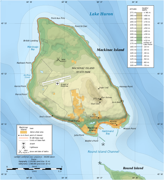
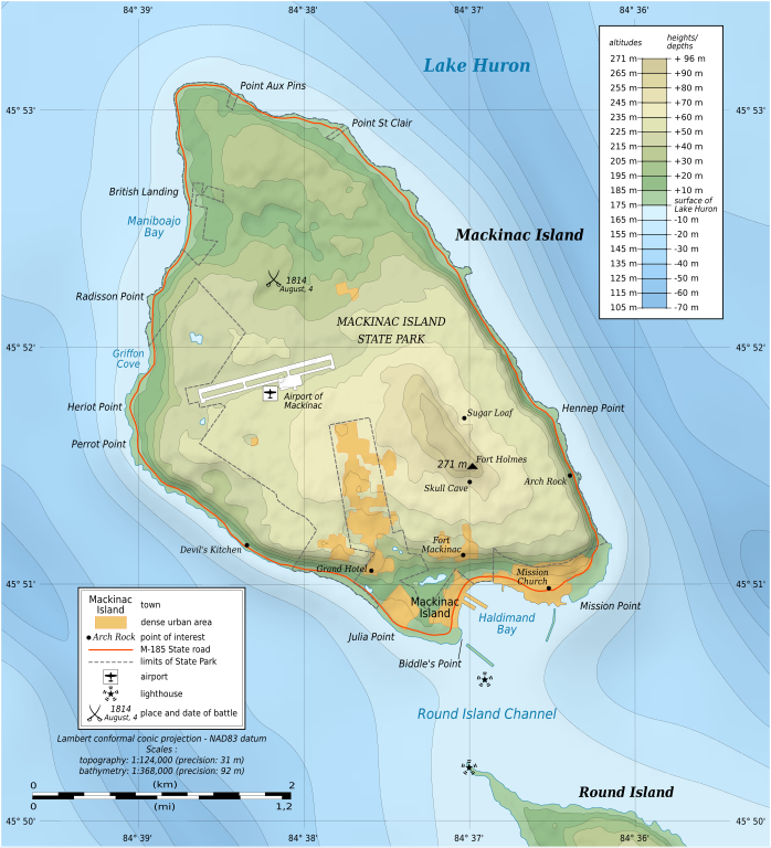
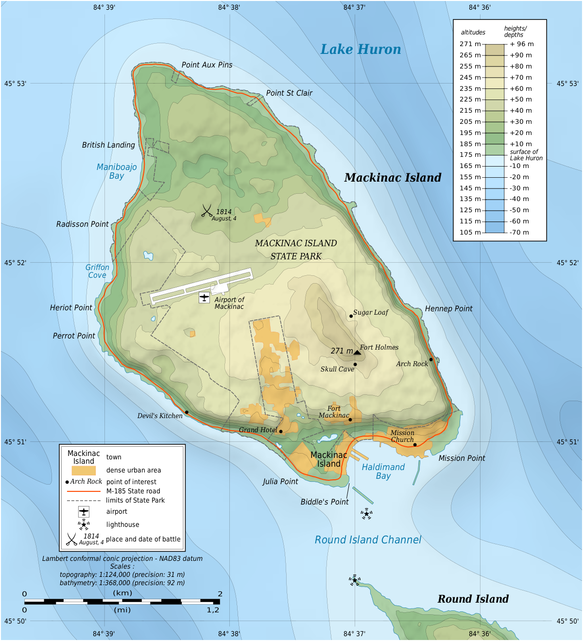
English: Topographic map in English of Mackinac Island, Lake Huron, Michigan, USA.
Note: The shaded relief is a raster image embedded in the SVG file. Français : Carte topographique en anglais de l'Île Mackinac, Lac Huron, Michigan, États-Unis. Note : Les ombres du relief sont une image bitmap embarquée dans le fichier SVG. Lambert conformal conic projection – NAD83 datum
|
||
| 日期 | |||
| 來源 |
自己的作品
|
||
| 作者 | Eric Gaba (Sting - fr:Sting) | ||
| 授權許可 (重用此檔案) |
|
||
| 其他版本 |
|


|
This SVG file contains embedded text that can be translated into your language, using any capable SVG editor, text editor or the SVG Translate tool. For more information see: About translating SVG files. |
授權條款
[編輯]
我,本作品的著作權持有者,決定用以下授權條款發佈本作品:

|
已授權您依據自由軟體基金會發行的無固定段落、封面文字和封底文字GNU自由文件授權條款1.2版或任意後續版本,對本檔進行複製、傳播和/或修改。該協議的副本列在GNU自由文件授權條款中。 |
此檔案採用共享創意 姓名標示-相同方式分享 3.0 未在地化版本授權條款。
- 您可以自由:
- 分享 – 複製、發佈和傳播本作品
- 重新修改 – 創作演繹作品
- 惟需遵照下列條件:
- 姓名標示 – 您必須指名出正確的製作者,和提供授權條款的連結,以及表示是否有對內容上做出變更。您可以用任何合理的方式來行動,但不得以任何方式表明授權條款是對您許可或是由您所使用。
- 相同方式分享 – 如果您利用本素材進行再混合、轉換或創作,您必須基於如同原先的相同或兼容的條款,來分布您的貢獻成品。
您可以選擇您需要的授權條款。
檔案歷史
點選日期/時間以檢視該時間的檔案版本。
| 日期/時間 | 縮圖 | 尺寸 | 用戶 | 備註 | |
|---|---|---|---|---|---|
| 目前 | 2010年7月7日 (三) 17:43 | | 1,200 × 1,320(457 KB) | Liandrei(對話 | 貢獻) | fix |
| 2010年7月7日 (三) 17:39 |  | 1,196 × 1,316(133 KB) | Liandrei(對話 | 貢獻) | fix | |
| 2010年7月7日 (三) 17:35 |  | 1,196 × 1,316(133 KB) | Liandrei(對話 | 貢獻) | Removed border | |
| 2009年6月9日 (二) 01:37 |  | 1,200 × 1,320(462 KB) | Sting(對話 | 貢獻) | == Summary == {{Location|45|51|53|N|84|37|30|W|scale:30000}} {{Information| |Description={{en|Topographic map in English of Mackinac Island, Lake Huron, Michigan, USA.<br/>''Note: The shaded relief is a raster image embedded in th |
無法覆蓋此檔案。
檔案用途
下列3個頁面有用到此檔案:
全域檔案使用狀況
以下其他 wiki 使用了這個檔案:
- ca.wikipedia.org 的使用狀況
- de.wikipedia.org 的使用狀況
- en.wikipedia.org 的使用狀況
- Mackinac Island
- Fort Mackinac
- Fort Holmes
- Mackinac Island State Park
- Andrew Holmes (army officer)
- Battle of Mackinac Island (1814)
- Mission House (Mackinac Island)
- Arch Rock (Mackinac Island)
- Round Island Light, Michigan
- Marquette Park (Mackinac Island)
- Round Island Passage Light
- Wikipedia:Graphics Lab/Photography workshop/Archive/Jul 2010
- File talk:Mackinac Island topographic map-en.svg
- Portal:Islands/Selected article
- Portal:Islands/Selected article/55
- en.wikivoyage.org 的使用狀況
- es.wikipedia.org 的使用狀況
- fr.wikipedia.org 的使用狀況
- ja.wikipedia.org 的使用狀況
- kk.wikipedia.org 的使用狀況
- nl.wikipedia.org 的使用狀況
- pl.wikipedia.org 的使用狀況
- ru.wikipedia.org 的使用狀況
- www.wikidata.org 的使用狀況
- xmf.wikipedia.org 的使用狀況
- zh.wikipedia.org 的使用狀況