File:Macquarie Island map - Mawson.gif
跳至導覽
跳至搜尋

預覽大小:454 × 599 像素。 其他解析度:182 × 240 像素 | 364 × 480 像素 | 640 × 844 像素。
原始檔案 (640 × 844 像素,檔案大小:21 KB,MIME 類型:image/gif)
說明
說明
添加單行說明來描述出檔案所代表的內容
摘要[編輯]
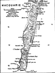
| 描述 | Contour map of Macquarie Island. |
| 來源 | The Home of the Blizzard - Being the Story of the Australasian Antarctic Expedition, 1911-1914, by Douglas Mawson. Project Gutenberg etext 6137, file txt3.gif. |
| 作者 | Mawson, Douglas, 1882-1958 |
| 授權許可 (重用此檔案) |
Public domain in the US |
授權條款[編輯]
此圖片或其他作品來自澳洲,因為其著作權保護期限到期,所以現在屬於公有領域。根據澳洲版權協會(ACC)和ACC資訊表格G023v19(版權期限)(2019年1月):1
使用此模板時,請提供有關圖片首次出版的位置和作者的資訊。 |
 | |||||||||||||||||||
此圖片或其他作品來自澳洲,因為其著作權保護期限到期,所以現在屬於公有領域。根據澳洲版權協會(ACC)和ACC資訊表格G023v19(版權期限)(2019年1月):1
使用此模板時,請提供有關圖片首次出版的位置和作者的資訊。 |
| |||||||||||||||||||
First published in Mawson, D. (1914). The Home of the Blizzard.
檔案歷史
點選日期/時間以檢視該時間的檔案版本。
| 日期/時間 | 縮圖 | 尺寸 | 用戶 | 備註 | |
|---|---|---|---|---|---|
| 目前 | 2007年5月13日 (日) 14:32 | | 640 × 844(21 KB) | Avenue(對話 | 貢獻) | {{Information |Description=Contour map of Macquarie Island. |Source=The Home of the Blizzard - Being the Story of the Australasian Antarctic Expedition, 1911-1914, by Douglas Mawson. [http://www.gutenberg.org/etext/6137 Project Gutenberg etext 6137], file |
無法覆蓋此檔案。
檔案用途
沒有使用此檔案的頁面。
全域檔案使用狀況
以下其他 wiki 使用了這個檔案:
- be-tarask.wikipedia.org 的使用狀況
- bg.wikipedia.org 的使用狀況
- fr.wikipedia.org 的使用狀況
- pl.wikipedia.org 的使用狀況
- pt.wikipedia.org 的使用狀況
- uk.wikipedia.org 的使用狀況
- zh.wikipedia.org 的使用狀況