File:Madagascar tamo 2023031 lrg.jpg
Jump to navigation
Jump to search

Size of this preview: 800 × 354 pixels. Other resolutions: 320 × 142 pixels | 640 × 283 pixels | 1,024 × 453 pixels | 1,280 × 567 pixels | 4,620 × 2,046 pixels.
Original file (4,620 × 2,046 pixels, file size: 1.55 MB, MIME type: image/jpeg)
Captions
Captions
Add a one-line explanation of what this file represents
Summary[edit]
| Description |
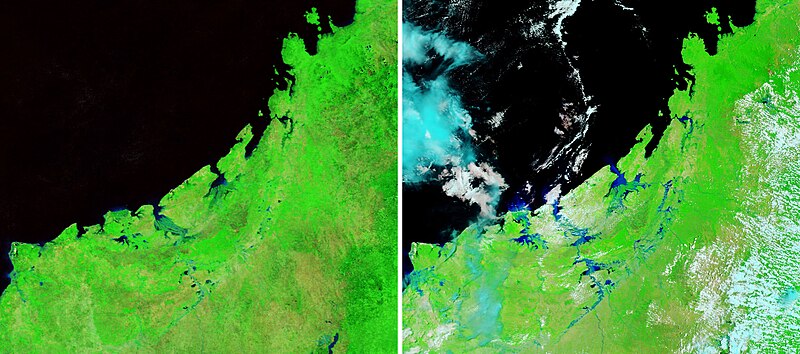
English: False-color satellite image of floods and landslides in Madagascar from Cyclone Cheneso.
NASA Earth Observatory Image of the Day for February 1, 2023 |
| Date | |
| Source | https://earthobservatory.nasa.gov/images/150910/cheneso-floods-madagascar |
| Author | NASA Earth Observatory images by Joshua Stevens, using Landsat data from the U.S. Geological Survey and MODIS data from NASA EOSDIS LANCE and GIBS/Worldview. |
Licensing[edit]
| This file is in the public domain in the United States because it was solely created by NASA. NASA copyright policy states that "NASA material is not protected by copyright unless noted". (See Template:PD-USGov, NASA copyright policy page or JPL Image Use Policy.) | ||
 |
Warnings:
|
File history
Click on a date/time to view the file as it appeared at that time.
| Date/Time | Thumbnail | Dimensions | User | Comment | |
|---|---|---|---|---|---|
| current | 23:22, 4 November 2023 | | 4,620 × 2,046 (1.55 MB) | Lupe (talk | contribs) | Uploaded a work by NASA Earth Observatory images by Joshua Stevens, using Landsat data from the U.S. Geological Survey and MODIS data from NASA EOSDIS LANCE and GIBS/Worldview. from https://earthobservatory.nasa.gov/images/150910/cheneso-floods-madagascar with UploadWizard |
You cannot overwrite this file.
File usage on Commons
The following page uses this file: