File:Magadan 1978 (cropped to Zavyalov Island).jpg
Jump to navigation
Jump to search
No higher resolution available.
Magadan_1978_(cropped_to_Zavyalov_Island).jpg (300 × 130 pixels, file size: 46 KB, MIME type: image/jpeg)
Captions
Captions
Add a one-line explanation of what this file represents
Summary[edit]
| Description |
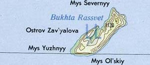
English: Magadan area of far east Russia |
| Date | |
| Source | Portion of Magadan sheet. Topographic Map NO 56, Series 1301. Original Scale 1:1,000,000. Printed by U.S. Defense Mapping Agency Topographic Center, 1978. From the PCL map collection, courtesy of the University of Texas Libraries, The University of Texas at Austin.[1] Transferred from en.wikipedia to Commons by Maksim. |
| Author | U.S. Defense Mapping Agency Topographic Center |
| Other versions |

.jpg&action=edit§ion=1)
This image is a work of a U.S. military or Department of Defense employee, taken or made as part of that person's official duties. As a work of the U.S. federal government, the image is in the public domain in the United States.
|
 |
File history
Click on a date/time to view the file as it appeared at that time.
| Date/Time | Thumbnail | Dimensions | User | Comment | |
|---|---|---|---|---|---|
| current | 08:36, 6 March 2024 | | 300 × 130 (46 KB) | Argo Navis (talk | contribs) | File:Magadan 1978.jpg cropped 54 % horizontally, 83 % vertically using CropTool with precise mode. |
You cannot overwrite this file.
File usage on Commons
The following page uses this file:
File usage on other wikis
The following other wikis use this file:
- Usage on hr.wikipedia.org
.jpg&oldid=859386531)