File:Magna Graecia ancient colonies and dialects-de.svg
跳至導覽
跳至搜尋

此 SVG 檔案的 PNG 預覽的大小:440 × 414 像素。 其他解析度:255 × 240 像素 | 510 × 480 像素 | 816 × 768 像素 | 1,088 × 1,024 像素 | 2,177 × 2,048 像素。
原始檔案 (SVG 檔案,表面大小:440 × 414 像素,檔案大小:126 KB)
說明
說明
添加單行說明來描述出檔案所代表的內容

|
This SVG file contains embedded text that can be translated into your language, using any capable SVG editor, text editor or the SVG Translate tool. For more information see: About translating SVG files. |
摘要
[編輯]| 描述 |
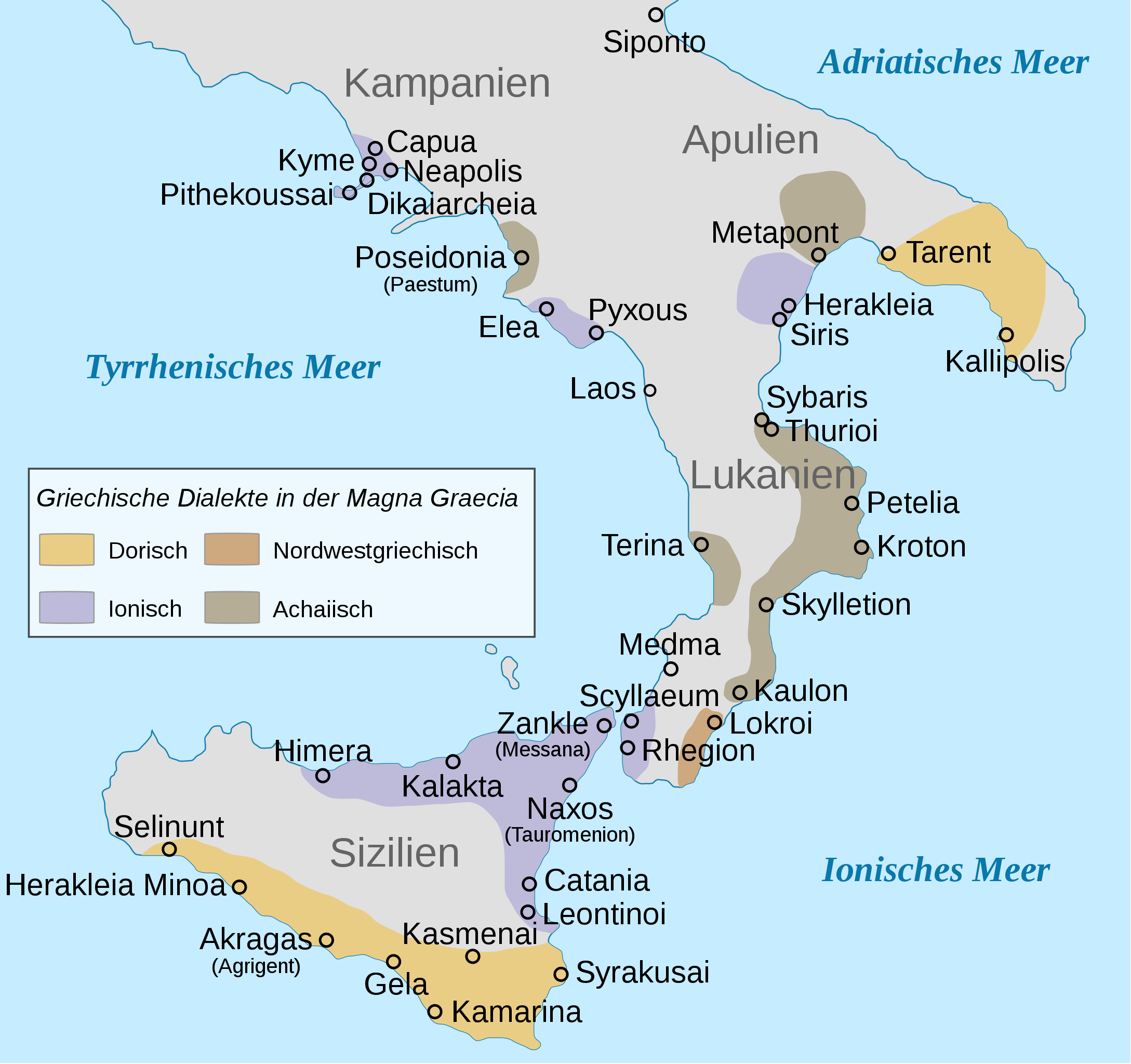
Deutsch: Karte der altgriechischen Kolonien und Dialekte der Magna Graecia, mit deutschem Text
English: Map of Magna Graecia, ancient colonies and dialects, with german labels |
| 日期 | |
| 來源 | 自己的作品. Übersetzung von File:Magna Graecia ancient colonies and dialects-en.svg |
| 作者 | Future Perfect at Sunrise (original English SVG); Isssabellla (German translation) |
| 其他版本 |
[] Maps following Woodward 2008[編輯]Based on: Roger D. Woodard, "Greek dialects", in The Ancient Languages of Europe, ed. Roger D. Woodard, Cambridge: Cambridge University Press, 2008, p. 50. (= partial re-published version of The Cambridge Encyclopedia of Ancient Languages, 2004).
Maps following Horrocks 2006[編輯]Based on: G. Horrocks, Ελληνικά: Ιστορία της γλώσσας και των ομιλητών της, Athens, 2006, p. 71 (in turn after J. M. Hall, "The role of language in Greek ethnicities". Proceedings of the Cambridge Philological Society 41 (1995), 83-100).
Based on Horrocks, with original data (Athenian colonies and coasts in 400 BC):
|
_en.svg&lang=ca)
_en.svg)
_grc.svg)
_cs.svg)
_de.svg)
_fr.svg)
_hr.svg)
-hu.svg)
_id.svg)
_it.svg)
_la.svg)
_mk.svg)
-pl.svg)
_pt.svg)
_ru.svg)
_zh.svg)


-fr.svg)
-es.svg)
授權條款
[編輯]
| 我,此作品的版權所有人,釋出此作品至公共領域。此授權條款在全世界均適用。 這可能在某些國家不合法,如果是的話: 我授予任何人有權利使用此作品於任何用途,除受法律約束外,不受任何限制。 |
檔案歷史
點選日期/時間以檢視該時間的檔案版本。
| 日期/時間 | 縮圖 | 尺寸 | 用戶 | 備註 | |
|---|---|---|---|---|---|
| 目前 | 2014年11月7日 (五) 11:33 | | 440 × 414(126 KB) | Isssabellla(對話 | 貢獻) | User created page with UploadWizard |
無法覆蓋此檔案。
檔案用途
下列31個頁面有用到此檔案:
- File:AncientGreekDialects (Woodard)-hu.svg
- File:AncientGreekDialects (Woodard)-pl.svg
- File:AncientGreekDialects (Woodard) cs.svg
- File:AncientGreekDialects (Woodard) de.svg
- File:AncientGreekDialects (Woodard) en.svg
- File:AncientGreekDialects (Woodard) fr.svg
- File:AncientGreekDialects (Woodard) grc.svg
- File:AncientGreekDialects (Woodard) hr.svg
- File:AncientGreekDialects (Woodard) id.svg
- File:AncientGreekDialects (Woodard) it.svg
- File:AncientGreekDialects (Woodard) la.svg
- File:AncientGreekDialects (Woodard) mk.svg
- File:AncientGreekDialects (Woodard) pt.svg
- File:AncientGreekDialects (Woodard) ru.svg
- File:AncientGreekDialects (Woodard) zh.svg
- File:Ancient greek dialects-en.svg
- File:Ancient greek dialects-fr-400.jpg
- File:Ancient greek dialects-fr.svg
- File:Ancient greek dialects-grc.svg
- File:Ancient greek dialects-no.svg
- File:Ancient greek dialects (-400)-es.svg
- File:Ancient greek dialects (-400)-fr.svg
- File:Magna Graecia ancient colonies and dialects-de.svg
- File:Magna Graecia ancient colonies and dialects-el.svg
- File:Magna Graecia ancient colonies and dialects-es.svg
- File:Magna Graecia ancient colonies and dialects-eu.svg
- File:Magna Graecia ancient colonies and dialects-fr.svg
- File:Magna Graecia ancient colonies and dialects-id.svg
- File:Magna Graecia ancient colonies and dialects-pt.svg
- File:Magna Graecia ancient colonies and dialects-zh.svg
- Template:Other versions/Map Ancient Greek dialects
全域檔案使用狀況
以下其他 wiki 使用了這個檔案:
- de.wikipedia.org 的使用狀況
- de.wikivoyage.org 的使用狀況