File:MahaleMtsNP ETM+ 2001-10-01.jpg
Jump to navigation
Jump to search

Size of this preview: 600 × 600 pixels. Other resolutions: 240 × 240 pixels | 480 × 480 pixels | 768 × 768 pixels | 1,024 × 1,024 pixels | 2,400 × 2,400 pixels.
Original file (2,400 × 2,400 pixels, file size: 3.04 MB, MIME type: image/jpeg)
Captions
Captions
Add a one-line explanation of what this file represents
Summary
[edit]
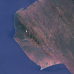
| Description | Satellite image of w:Mahale Mountains National Park along w:Lake Tanganyika, Tanzania. The park borders are outlined in yellow. |
| Date | |
| Source | http://earthobservatory.nasa.gov/Newsroom/NewImages/images.php3?img_id=17092 |
| Author | Jesse Allen, NASA Earth Observatory, using data obtained courtesy of the University of Maryland’s Global Land Cover Facility. |
| Permission (Reusing this file) |
US government, public domain |
Licensing
[edit]
| This file is in the public domain in the United States because it was solely created by NASA. NASA copyright policy states that "NASA material is not protected by copyright unless noted". (See Template:PD-USGov, NASA copyright policy page or JPL Image Use Policy.) | ||
 |
Warnings:
|
File history
Click on a date/time to view the file as it appeared at that time.
| Date/Time | Thumbnail | Dimensions | User | Comment | |
|---|---|---|---|---|---|
| current | 17:14, 2 May 2006 | | 2,400 × 2,400 (3.04 MB) | Holly Cheng (talk | contribs) | {{Information | Description=Satellite image of w:Mahale Mountains National Park along w:Lake Tanganyika, Tanzania. The park borders are outlined in yellow. | Source=http://earthobservatory.nasa.gov/Newsroom/NewImages/images.php3?img_id=17092 | Dat |
You cannot overwrite this file.
File usage on Commons
There are no pages that use this file.
File usage on other wikis
The following other wikis use this file:
- Usage on ar.wikipedia.org
- Usage on bg.wikipedia.org
- Usage on en.wikipedia.org
- Usage on fi.wikipedia.org
- Usage on fr.wikipedia.org
- Usage on it.wikipedia.org
- Usage on ru.wikipedia.org
- Usage on uk.wikipedia.org
- Usage on zh.wikipedia.org