File:Main GUI of GeoDa. The map view shows resource deprivation by county in 1960.png
Jump to navigation
Jump to search

Size of this preview: 800 × 337 pixels. Other resolutions: 320 × 135 pixels | 640 × 269 pixels | 1,758 × 740 pixels.
Original file (1,758 × 740 pixels, file size: 690 KB, MIME type: image/png)
Captions
Captions
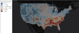
Main GUI of GeoDa. The map view shows resource deprivation by county in 1960.
Summary[edit]
| Description |
English: Main GUI of GeoDa. The map view shows resource deprivation by county in 1960. |
| Date | |
| Source | Own work |
| Author | Ehleeuchicago |
Licensing[edit]
I, the copyright holder of this work, hereby publish it under the following license:
This file is licensed under the Creative Commons Attribution-Share Alike 4.0 International license.
- You are free:
- to share – to copy, distribute and transmit the work
- to remix – to adapt the work
- Under the following conditions:
- attribution – You must give appropriate credit, provide a link to the license, and indicate if changes were made. You may do so in any reasonable manner, but not in any way that suggests the licensor endorses you or your use.
- share alike – If you remix, transform, or build upon the material, you must distribute your contributions under the same or compatible license as the original.
File history
Click on a date/time to view the file as it appeared at that time.
| Date/Time | Thumbnail | Dimensions | User | Comment | |
|---|---|---|---|---|---|
| current | 16:54, 5 April 2021 | | 1,758 × 740 (690 KB) | Ehleeuchicago (talk | contribs) | Uploaded own work with UploadWizard |
You cannot overwrite this file.
File usage on Commons
There are no pages that use this file.
File usage on other wikis
The following other wikis use this file: