File:Main House, Snee Farm, Mount Pleasant, SC - 50738328981.jpg
Jump to navigation
Jump to search

Size of this preview: 449 × 599 pixels. Other resolutions: 180 × 240 pixels | 360 × 480 pixels | 576 × 768 pixels | 768 × 1,024 pixels | 1,536 × 2,048 pixels | 3,004 × 4,006 pixels.
Original file (3,004 × 4,006 pixels, file size: 6.67 MB, MIME type: image/jpeg)
Captions
Captions
Add a one-line explanation of what this file represents
Summary[edit]
| Description |
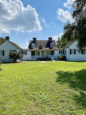
English: Acquired by Colonel Charles Pinckney in 1754, this land was once part of 715 acres he utilized in the cultivation of the cash crops of rice and indigo, utilizing slave labor. In 1782, the farm was bequeathed to his son, Charles Pinckney Jr, one of the signers of the US Constitution, a US Senator, member of the House of Representatives, and the 37th Governor of South Carolina. Snee Farm was used by Charles Pinckney as a working plantation and country estate until 1816, when, encumbered by debt, he placed the farm into a trust. The farm was then acquired by Francis G. Deliesselines in 1817, before passing to William Mathews, a planter, in 1828. Under the ownership of Mathews, whom owned the land until 1848, the buildings that had stood on the land during the ownership by the Pinckney family were demolished, and the central wing of the present house was constructed. In the 1930s, the house was expanded with the addition of two one-story side wings, which gave the house its present appearance. The farm remained at its full size with most of its outbuildings still standing until the 1970s, when development began to encroach onto the site. The owners at the time decided to begin subdividing the land for development. However, following a preservation battle, the house and the 28 acres surrounding it were purchased in 1988 by preservationists, and then sold to the National Park Service to be operated as a National Historic Site. The extent of what is known about the Pinckney family’s life at the farm is limited to archeological excavation and interpreting historical records, as the structures that stood on the site during their ownership are long gone. Snee Farm was listed on the National Register of Historic Places and as a National Historic Landmark in 1973. |
| Date | |
| Source | https://www.flickr.com/photos/59081381@N03/50738328981/ |
| Author | w_lemay |
| Camera location | | View this and other nearby images on: OpenStreetMap |
|---|
Licensing[edit]
This file is licensed under the Creative Commons Attribution-Share Alike 2.0 Generic license.
- You are free:
- to share – to copy, distribute and transmit the work
- to remix – to adapt the work
- Under the following conditions:
- attribution – You must give appropriate credit, provide a link to the license, and indicate if changes were made. You may do so in any reasonable manner, but not in any way that suggests the licensor endorses you or your use.
- share alike – If you remix, transform, or build upon the material, you must distribute your contributions under the same or compatible license as the original.
| This image was originally posted to Flickr by w_lemay at https://flickr.com/photos/59081381@N03/50738328981. It was reviewed on 4 March 2023 by FlickreviewR 2 and was confirmed to be licensed under the terms of the cc-by-sa-2.0. |
File history
Click on a date/time to view the file as it appeared at that time.
| Date/Time | Thumbnail | Dimensions | User | Comment | |
|---|---|---|---|---|---|
| current | 18:32, 4 March 2023 | | 3,004 × 4,006 (6.67 MB) | Ser Amantio di Nicolao (talk | contribs) | Uploaded a work by w_lemay from https://www.flickr.com/photos/59081381@N03/50738328981/ with UploadWizard |
You cannot overwrite this file.
File usage on Commons
There are no pages that use this file.