File:Maison Beatty, 69, avenue Lorne, Saint-Lambert Chambly entrée 11-d.na.civile-90-2096.jpg
Jump to navigation
Jump to search

Size of this preview: 800 × 517 pixels. Other resolutions: 320 × 207 pixels | 640 × 413 pixels | 1,024 × 662 pixels | 1,500 × 969 pixels.
Original file (1,500 × 969 pixels, file size: 1.06 MB, MIME type: image/jpeg)
Captions
Captions
Add a one-line explanation of what this file represents
Summary
Object
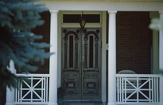
| Français : Maison Beatty, 69, avenue Lorne, Saint-Lambert (Chambly) : entrée
( |
|||||||||||||||||||||
|---|---|---|---|---|---|---|---|---|---|---|---|---|---|---|---|---|---|---|---|---|---|
| Title |
Français : Maison Beatty, 69, avenue Lorne, Saint-Lambert (Chambly) : entrée |
||||||||||||||||||||
| Description |
Français : Autres titres : Maison Beatty-Shaw. Description : La maison Beatty-Shaw, construite en 1887, présente un intérêt patrimonial en raison notamment de son architecture qui témoigne de la popularité de l'architecture d'esprit Second-Empire. Dans les années 1880 et 1890, la mode du toit mansardé bat son plein au Québec, toutes classes sociales confondues. Bien souvent, les modèles résidentiels de l'époque adoptent le toit mansardé, sans plus. Dans le cas de la maison Beatty-Shaw, on note un effort supplémentaire. L'ajout d'une tour à mansarde fait en effet clairement référence à une influence plus large. Décentrée, la tour ajoute un aspect pittoresque à la composition, cette influence faisait partie intégrante du langage Second-Empire, particulièrement dans sa transposition dans l'architecture résidentielle en sol américain. L'ajout d'une galerie avec colonnes doriques participe aussi à cet effet, tout en rappelant les racines classiques du courant stylistique. La marge de recul par rapport à la rue permet aussi la mise en scène de la composition dont le côté pittoresque suggère un lien avec la nature. (Source : https://www.patrimoine-culturel.gouv.qc.ca/rpcq/detail.do?methode=consulter&id=216352&type=bien) |
||||||||||||||||||||
| Date |
Français : 1887 |
||||||||||||||||||||
| Medium | color photography | ||||||||||||||||||||
| Dimensions | height: 5 cm (1.9 in); width: 5 cm (1.9 in) | ||||||||||||||||||||
| Collection |
|
||||||||||||||||||||
| Current location |
|
||||||||||||||||||||
| Accession number |
11-d.na.civile-90-2096 |
||||||||||||||||||||
| Notes |
Français : Image réalisée sous la direction de Luc Noppen dans le cadre des travaux du Groupe de recherche en art du Québec (GRAQ) vers 1990 |
||||||||||||||||||||

Photograph
| Date | |||||||||||||||||||||||||||
| Source |
|
||||||||||||||||||||||||||
| Author | Groupe de recherche en art du Québec | ||||||||||||||||||||||||||
| Permission (Reusing this file) |
This file is licensed under the Creative Commons Attribution-Share Alike 4.0 International license.
|
||||||||||||||||||||||||||

File history
Click on a date/time to view the file as it appeared at that time.
| Date/Time | Thumbnail | Dimensions | User | Comment | |
|---|---|---|---|---|---|
| current | 21:15, 3 January 2023 | | 1,500 × 969 (1.06 MB) | Cephas (talk | contribs) | pattypan 22.02 |
You cannot overwrite this file.
File usage on Commons
The following page uses this file: