File:Maja Valles Streamlined Island.jpg
Jump to navigation
Jump to search

Size of this preview: 550 × 599 pixels. Other resolutions: 220 × 240 pixels | 614 × 669 pixels.
Original file (614 × 669 pixels, file size: 53 KB, MIME type: image/jpeg)
Captions
Captions
Add a one-line explanation of what this file represents
Summary[edit]
| Description |
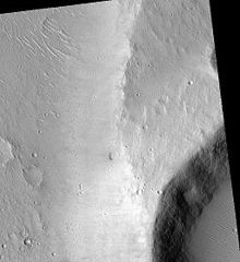
English: Maja Valles Streamlined Island, as seen by hirise. Location is 15.8 degrees north latitude and 301.9 degrees east longitude. Image was taken by the Mars Reconnaissance Orbiter's HiRISE. The HiRISE camera was built by Ball Aerospace and Technology orporation and is operated by the University of Arizona. Image courtesy NASA/JPL/University of Arizona. |
| Date | |
| Source | http://hirise.lpl.arizona.edu/PSP_002181_1960 |
| Author | Jim Secosky modified NASA image. |
Licensing[edit]
| This file is in the public domain in the United States because it was solely created by NASA. NASA copyright policy states that "NASA material is not protected by copyright unless noted". (See Template:PD-USGov, NASA copyright policy page or JPL Image Use Policy.) | ||
 |
Warnings:
|
Original upload log[edit]
The original description page was here. All following user names refer to en.wikipedia.
| Date/Time | Dimensions | User | Comment |
|---|---|---|---|
| 2009-03-11 22:26 | 614×669× (53856 bytes) | Jimmarsmars | {{Information |Description=Maja Valles Streamlined Island, as seen by hirise. Location is 15.8 degrees north latitude and 301.9 degrees east longitude. |Source=http://hirise.lpl.arizona.edu/PSP_002181_1960 |Date=March 11, 2009 |Author=Jim Secosky modifie |
File history
Click on a date/time to view the file as it appeared at that time.
| Date/Time | Thumbnail | Dimensions | User | Comment | |
|---|---|---|---|---|---|
| current | 01:03, 27 November 2014 | | 614 × 669 (53 KB) | Piramidion (talk | contribs) | Transferred from en.wikipedia |
You cannot overwrite this file.
File usage on Commons
There are no pages that use this file.
File usage on other wikis
The following other wikis use this file:
- Usage on cs.wikipedia.org
- Usage on en.wikipedia.org
- Usage on uk.wikipedia.org
- Usage on zh.wikipedia.org