File:Makambo Island under attack August 1942.jpeg
Jump to navigation
Jump to search

Size of this preview: 800 × 592 pixels. Other resolutions: 320 × 237 pixels | 640 × 474 pixels | 1,024 × 758 pixels | 1,280 × 947 pixels | 1,915 × 1,417 pixels.
Original file (1,915 × 1,417 pixels, file size: 675 KB, MIME type: image/jpeg)
Captions
Captions
Add a one-line explanation of what this file represents
Summary
[edit]
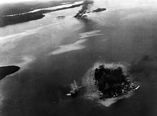
| Description | Aerial reconnaissance photograph showing Makambo Island under bombardment by ships and planes of the U.S. Pacific Fleet. Tanambogo and Gavutu are visible in the background. |
| Date | |
| Source | U.S. Navy National Museum of Naval Aviation photo No. 2001.205.177 |
| Author | U.S. Navy |
| Camera location | | View this and other nearby images on: OpenStreetMap |
|---|
Licensing
[edit]
This file is a work of a sailor or employee of the U.S. Navy, taken or made as part of that person's official duties. As a work of the U.S. federal government, it is in the public domain in the United States.
|
 | |
| This file has been identified as being free of known restrictions under copyright law, including all related and neighboring rights. | ||
File history
Click on a date/time to view the file as it appeared at that time.
| Date/Time | Thumbnail | Dimensions | User | Comment | |
|---|---|---|---|---|---|
| current | 16:07, 30 August 2011 | | 1,915 × 1,417 (675 KB) | Cobatfor (talk | contribs) | == {{int:filedesc}} == {{Information |Description=Aerial reconnaissance photograph showing Makambo Island under bombardment by ships and planes of the U.S. Pacific Fleet. Tanambogo and Gavutu are visible in the background. |Source=[http://collections.nava |
You cannot overwrite this file.
File usage on Commons
There are no pages that use this file.