File:Malawi regions map (cs).png
Jump to navigation
Jump to search

Size of this preview: 366 × 600 pixels. Other resolutions: 146 × 240 pixels | 586 × 960 pixels.
Original file (586 × 960 pixels, file size: 253 KB, MIME type: image/png)
Captions
Captions
Add a one-line explanation of what this file represents
Summary[edit]
.png&action=edit§ion=1)
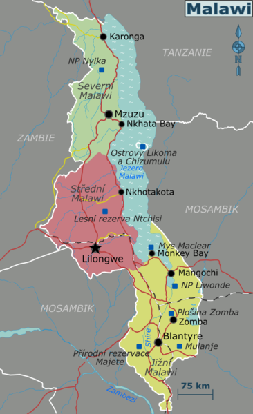
| Description | Map of Malawi with regions, major cities and other destinations noted (for use on Wikivoyage), Czech version |
| Date | |
| Source | Own work based on File:Malawi regions.svg |
| Author | Shaund, Czech translation: Honza Záruba |
Licensing[edit]
.png&action=edit§ion=2)
This file is licensed under the Creative Commons Attribution-Share Alike 4.0 International license.
- You are free:
- to share – to copy, distribute and transmit the work
- to remix – to adapt the work
- Under the following conditions:
- attribution – You must give appropriate credit, provide a link to the license, and indicate if changes were made. You may do so in any reasonable manner, but not in any way that suggests the licensor endorses you or your use.
- share alike – If you remix, transform, or build upon the material, you must distribute your contributions under the same or compatible license as the original.
File history
Click on a date/time to view the file as it appeared at that time.
| Date/Time | Thumbnail | Dimensions | User | Comment | |
|---|---|---|---|---|---|
| current | 23:06, 30 January 2022 | | 586 × 960 (253 KB) | Honza Záruba (talk | contribs) | {{Information |Description=Map of Malawi with regions, major cities and other destinations noted (for use on Wikivoyage), Czech version |Source={{own}} based on File:Malawi regions.svg |Date=2022-01-31 |Author=Shaund, Czech translation: {{U|Honza Záruba}} |Permission= |other_versions= }} Category:Travel maps of Malawi |
You cannot overwrite this file.
File usage on Commons
The following 2 pages use this file:
File usage on other wikis
The following other wikis use this file:
- Usage on incubator.wikimedia.org
.png&oldid=740479656)