File:Malczyce (gmina) location map.png

Original file (608 × 959 pixels, file size: 130 KB, MIME type: image/png)
Captions
Captions
Summary
[edit]_location_map.png&action=edit§ion=1)
| Description |
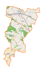
English: Location map |
| Date | |
| Source | Own work |
| Author | Smat |
| Description |
Polski: Mapa gminy Malczyce, Polska
English: Map of Malczyce (gmina), Poland |
|||||||||
| Date | ||||||||||
| Source | You may find a page on the OpenStreetMap wiki page for Malczyce (gmina) | |||||||||
| Creator |
OpenStreetMap contributors OpenStreetMap contributors |
|||||||||
| Permission (Reusing this file) |
OpenStreetMap data is available under the Open Database License (details). Map tiles are licensed under the Creative Commons Attribution-ShareAlike 2.0 license (CC-BY-SA 2.0).
This file is licensed under the Creative Commons Attribution-Share Alike 2.0 Generic license.
|
|||||||||
| Geotemporal data | ||||||||||
| Bounding box |
|
|||||||||
| Georeferencing | If inappropriate please set warp_status = skip to hide. | |||||||||
Licensing
[edit]_location_map.png&action=edit§ion=2)
| This work contains information from OpenStreetMap, which is made available under the Open Database License (ODbL).
The ODbL does not require any particular license for maps produced from ODbL data. Prior to 1 August 2020, map tiles produced by the OpenStreetMap Foundation were licensed under the CC-BY-SA-2.0 license. Maps produced by other people may be subject to other licences. |
File history
Click on a date/time to view the file as it appeared at that time.
| Date/Time | Thumbnail | Dimensions | User | Comment | |
|---|---|---|---|---|---|
| current | 10:07, 2 February 2017 | | 608 × 959 (130 KB) | Smat (talk | contribs) | User created page with UploadWizard |
You cannot overwrite this file.
File usage on Commons
There are no pages that use this file.
File usage on other wikis
The following other wikis use this file:
- Usage on de.wikipedia.org
- Usage on fr.wikipedia.org
- Usage on pl.wikipedia.org
- Malczyce
- Malczyce (gmina)
- Kwietno
- Mazurowice
- Rachów (województwo dolnośląskie)
- Chomiąża (województwo dolnośląskie)
- Dębice (województwo dolnośląskie)
- Chełm (powiat średzki)
- Rusko (powiat średzki)
- Szymanów (powiat średzki)
- Wilczków (powiat średzki)
- Zawadka (województwo dolnośląskie)
- Malczyce (stacja kolejowa)
- Parafia Zwiastowania Przenajświętszej Bogurodzicy w Malczycach
- Cerkiew Zwiastowania Przenajświętszej Bogurodzicy w Malczycach
- Port Malczyce
- Parafia Niepokalanego Poczęcia Najświętszej Maryi Panny w Malczycach
- Malczyce Port
- Parafia św. Michała Archanioła w Chomiąży
- Parafia Najświętszej Maryi Panny Różańcowej w Wilczkowie
- Pałac w Chełmie
- Pałac w Dębicach
- Pałac w Kwietnie
- Pałac w Rachowie
- Moduł:Mapa/dane/Malczyce (gmina)
- Kościół Niepokalanego Poczęcia Najświętszej Maryi Panny w Malczycach
- Wikipedysta:Malarz pl/szablony/Polska miejscowość infobox/1
- Usage on pl.wikibooks.org
_location_map.png&oldid=607600551)