File:Mamers Valles 2.jpg
Jump to navigation
Jump to search

Size of this preview: 321 × 599 pixels. Other resolutions: 128 × 240 pixels | 257 × 480 pixels | 411 × 768 pixels | 548 × 1,024 pixels | 1,414 × 2,639 pixels.
Original file (1,414 × 2,639 pixels, file size: 287 KB, MIME type: image/jpeg)
Captions
Captions
Add a one-line explanation of what this file represents
Summary
[edit]
| Description |
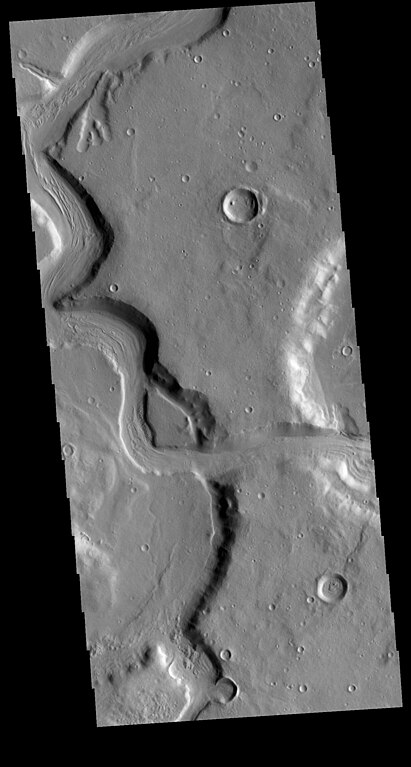
English: Today's VIS image shows a section of Mamers Valles. The channel is nearly 1000 km long. Mamers Valles originates near Cerulli Crater in northern Arabia Terra, and after a short section near the crater where flow is to the south, flows northward to empty in Deuteronilus Mensae. This image is located where the channel changes from southward flow to northward. On the right side of the image the channel cuts from one crater into a lower one. The channel hugs the wall of the second crater and then exits to the top of the image. The steep walls of Mamers Valles can reach heights of 1200 m. |
| Date | |
| Source | https://www.jpl.nasa.gov/spaceimages/details.php?id=PIA23750 |
| Author | NASA/JPL-Caltech/ASU |
Licensing
[edit]
| This file is in the public domain in the United States because it was solely created by NASA. NASA copyright policy states that "NASA material is not protected by copyright unless noted". (See Template:PD-USGov, NASA copyright policy page or JPL Image Use Policy.) | ||
 |
Warnings:
|
File history
Click on a date/time to view the file as it appeared at that time.
| Date/Time | Thumbnail | Dimensions | User | Comment | |
|---|---|---|---|---|---|
| current | 22:48, 21 March 2020 | | 1,414 × 2,639 (287 KB) | Astromessier (talk | contribs) | Uploaded a work by NASA/JPL-Caltech/ASU from https://www.jpl.nasa.gov/spaceimages/details.php?id=PIA23750 with UploadWizard |
You cannot overwrite this file.
File usage on Commons
There are no pages that use this file.
File usage on other wikis
The following other wikis use this file:
- Usage on es.wikipedia.org