File:Managua earthquake aerial view.jpg
Jump to navigation
Jump to search
No higher resolution available.
Managua_earthquake_aerial_view.jpg (367 × 464 pixels, file size: 218 KB, MIME type: image/jpeg)
Captions
Captions
Add a one-line explanation of what this file represents
Summary
[edit]
| Description |
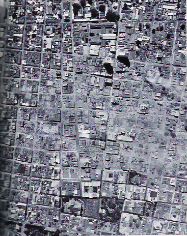
English: 1972 Nicaragua earthquake. Aerial photograph of downtown Managua shows still-smoldering rubble in region of heaviest earthquake damage. This view, taken from 3,000 feet by a National Aeronautics and Space Administration C-130, is part of extensive photographic coverage of the area being used by NOAA scientists to evaluate damage patterns. |
| Date | |
| Source | USGS taken by NOAA |
| Author | NOAA |
Licensing
[edit]
This image is in the public domain because it contains materials that originally came from the U.S. National Oceanic and Atmospheric Administration, taken or made as part of an employee's official duties.
|
File history
Click on a date/time to view the file as it appeared at that time.
| Date/Time | Thumbnail | Dimensions | User | Comment | |
|---|---|---|---|---|---|
| current | 08:12, 12 January 2009 | | 367 × 464 (218 KB) | Tochi nica (talk | contribs) | {{Information |Description={{en|1=Aerial photograph of downtown Managua shows still-smoldering rubble in region of heaviest earthquake damage. This view, taken from 3,000 feet by a National Aeronautics and Space Administration C-130, is part of extensive |
You cannot overwrite this file.
File usage
There are no pages that use this file.
Global file usage
The following other wikis use this file:
- Usage on eo.wikipedia.org
- Usage on es.wikipedia.org
- Usage on fr.wikipedia.org
- Usage on hr.wikipedia.org
- Usage on it.wikipedia.org
- Usage on sco.wikipedia.org
- Usage on sl.wikipedia.org
- Usage on sq.wikipedia.org
- Usage on sv.wikipedia.org
- Usage on www.wikidata.org