File:Manatvs gelegen op de Noot Riuier.jpg
跳转到导航
跳转到搜索

本预览的尺寸:800 × 575像素。 其他分辨率:320 × 230像素 | 640 × 460像素 | 1,024 × 736像素 | 1,280 × 920像素 | 2,560 × 1,839像素 | 8,752 × 6,288像素。
原始文件 (8,752 × 6,288像素,文件大小:9.24 MB,MIME类型:image/jpeg)
说明
说明
添加一行文字以描述该文件所表现的内容
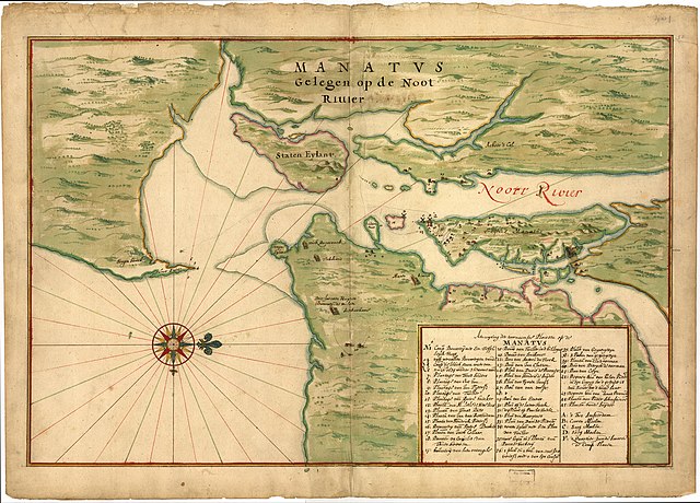
Manatvs (Manhattan) Laying Upon The North River.
| 警告 | 部分浏览器在浏览此图片的完整大小时可能会遇到困难:该图片中有数量巨大的像素点,可能无法完全载入或者导致您的浏览器停止响应。 |
|---|
| 描写 |
"Manatvs gelegen op de Noot [sic] Riuier" - a Dutch map of Manhattan and environs from around 1670, believed to be a copy of a 1639 map often attributed to Johannes Vingboons (a.k.a. Joan Vinckeboons).[1] |
|||||||||
| 日期 | c.1670 (believed to be a copy of a 1639 map) | |||||||||
| 来源 | Image of map at Library of Congress ([1]). | |||||||||
| 創作作者 |
sometimes attributed to Johannes Vingboons |
|||||||||
| Geotemporal data | ||||||||||
| 边框 |
|
|||||||||
| 地理参考 | ||||||||||
- ↑ (2009年) 《 Half Moon: Henry Hudson and the Voyage that Redrew the Map of the New World》、Bloomsbury Publishing USA、第278頁 ISBN: 1608190986.
|
本作品在其来源国以及其他著作权期限是作者逝世后100年或以下的国家和地区属于公有领域。 | |
| 本文件已被确认为免除已知的著作权法限制(包括所有相关权利)。 | |
文件历史
点击某个日期/时间查看对应时刻的文件。
| 日期/时间 | 缩略图 | 大小 | 用户 | 备注 | |
|---|---|---|---|---|---|
| 当前 | 2012年2月17日 (五) 17:03 | | 8,752 × 6,288(9.24 MB) | Gladiool(留言 | 贡献) | Original, full-resolution image. |
| 2007年4月28日 (六) 00:19 |  | 546 × 392(53 KB) | Mikepanhu(留言 | 贡献) | {{Information |Description=Joan Vinckeboons (Johannes Vingboon), "Manatvs gelegen op de Noot Riuier", 1639. |Source=[http://lcweb2.loc.gov/cgi-bin/map_item.pl?data=/home/www/data/gmd/gmd380/g3804/g3804n/ct000050.jp2&itemLink=r?ammem/gmd:@field(NUMBER+@ban |
您不可以覆盖此文件。
文件用途
以下3个页面使用本文件:
全域文件用途
以下其他wiki使用此文件:
- azb.wikipedia.org上的用途
- en.wikipedia.org上的用途
- New Netherland
- Italian Americans
- New York–New Jersey Harbor Estuary
- Jonas Bronck
- Colonial history of New Jersey
- Pavonia, New Netherland
- Bergen, New Netherland
- Communipaw
- User:Djflem
- New Netherland settlements
- Jan Everts Bout
- Hudson Waterfront
- User talk:Vissering
- User:Vissering
- Pietro Cesare Alberti
- Jochem Pietersen Kuyter
- User:Djflem/Holland Tunnel Rotary
- Andries Hudde
- Maryn Adriansen
- Abraham Isaacsen Verplanck
- User:Djflem/Stoffelson
- Talk:Stuyvesant Farm
- Manatus Map
- Cartography of New York City
- Italians in the United States before 1880
- New Amsterdam's windmills
- Sawkill mill
- es.wikipedia.org上的用途
- fr.wikipedia.org上的用途
- he.wikipedia.org上的用途
- ja.wikipedia.org上的用途
- no.wikipedia.org上的用途
- ru.wikipedia.org上的用途
- www.wikidata.org上的用途
- zh.wikipedia.org上的用途