File:Manaus-Amazon-NASA.jpg
跳至導覽
跳至搜尋
預覽大小:600 × 600 像素。 其他解析度:240 × 240 像素 | 480 × 480 像素 | 768 × 768 像素 | 1,024 × 1,024 像素 | 2,048 × 2,048 像素 | 5,312 × 5,312 像素。
原始檔案 (5,312 × 5,312 像素,檔案大小:8.7 MB,MIME 類型:image/jpeg)
說明
說明
添加單行說明來描述出檔案所代表的內容
摘要[編輯]
Descrption[編輯]
Transferred from en.wikipedia to Commons.
The original description page was here. All following user names refer to en.wikipedia.
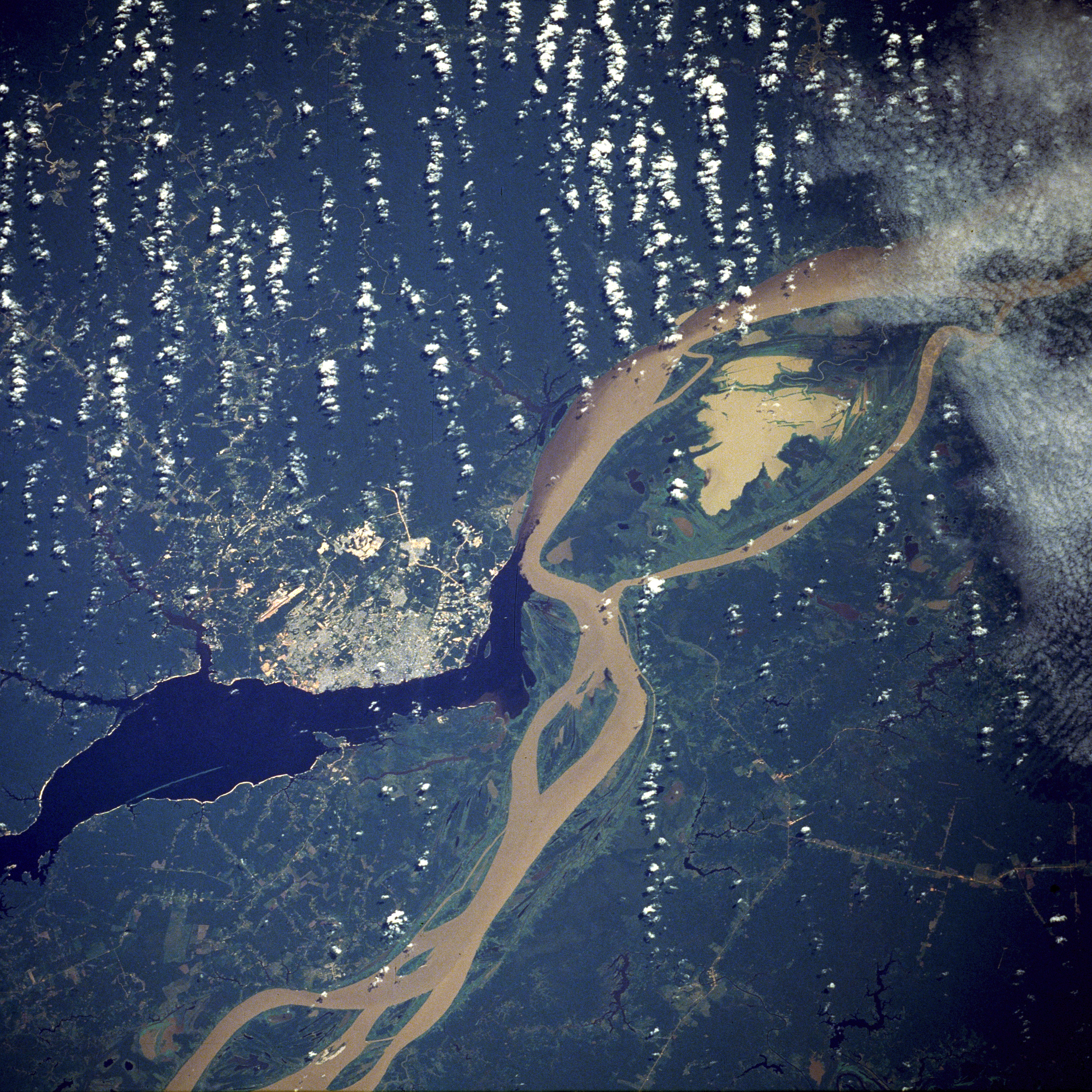
English: A satellite image of the city of Manaus with surrounding rivers.
English: Original caption:
- STS61C-33-84 Manaus, Amazonas, Brazil January 1986
- Two rivers and an urban area dominate this photograph. The largest city in the Amazon Basin, Manaus (with a 1994 population of 1.7 million), is located at the confluence of the Rio Negro (dark blue) and the Amazon River (lighter because of its high sediment content). The combined river flows eastward into the Atlantic Ocean. Situated approximately 800 miles (1290 kilometers) from the mouth of the Amazon River but accessible to oceangoing ships, Manaus is an important river port. This port city started to flourish in the late 1800s when the rubber boom was at its peak. Rubber, Brazil nuts, lumber, and assorted fruits are exported. In recent years, renewed interest in general development and the discovery of oil and manganese near Manaus have brought new importance to the city. A number of highways (linear, light-colored features), as well as a large commercial airport north of the city, are visible in the rain forest north and south of Manaus. North-south ground transportation is hindered because no bridges cross the Rio Negro or Amazon River. A large, sediment-laden lake (note irregular shoreline) is located east of Manaus between the main channel of the Amazon River and a smaller channel to the south.
Source[編輯]
http://earth.jsc.nasa.gov/sseop/EFS/photoinfo.pl?PHOTO=STS61C-33-84 (file)
English: Photo credit: NASA
本圖像或影音收錄於美國國家航空暨太空總署 (NASA)某部門,其照片編號為: STS61C-33-84 此標籤不表示文件的著作權狀態。任何文件在附有此標籤的同時還需要一個有效的著作權標籤。請參閱許可協議說明頁面以了解更多資訊。 其他語言:
|
English-Wikipedia:
| date/time | username | edit summary |
|---|---|---|
| 10:52, 14 December 2004 | en:User:Magnus Manske | ({{PD-USGov-NASA}}) |
| 18:15, 18 June 2004 | en:User:Sverdrup | (Image info) |
| 18:14, 18 June 2004 | en:User:Sverdrup | (A satellite image of the city of <a href="/wiki/Manaus" title="Manaus">Manaus</a> with surrounding rivers.) |
Other version: Image:Manaus-Amazon-NASA2.jpg
See also[編輯]

授權條款[編輯]
| 本作品由NASA創作,屬於公有領域。根據NASA的版權政策:“NASA的創作除非另有聲明否則不受版權保護。”(參見:Template:PD-USGov/zh,NASA版權政策或JPL圖像使用政策) | ||
 |
警告:
|
| 註解 | 該圖片含有註解:在維基媒體共享資源上查看註解 |
檔案歷史
點選日期/時間以檢視該時間的檔案版本。
| 日期/時間 | 縮圖 | 尺寸 | 用戶 | 備註 | |
|---|---|---|---|---|---|
| 目前 | 2011年11月20日 (日) 05:17 | | 5,312 × 5,312(8.7 MB) | Delirium(對話 | 貢獻) | much higher-resolution version from the same source |
| 2011年11月9日 (三) 04:38 |  | 640 × 640(262 KB) | Creysmon07(對話 | 貢獻) | Corrected the contrast to a more realistic. | |
| 2006年1月29日 (日) 14:41 |  | 640 × 640(157 KB) | Maksim(對話 | 貢獻) | La bildo estas kopiita de wikipedia:en. La originala priskribo estas: A satellite image of the city of Manaus with surrounding rivers. '''Original caption:''' :''STS61C-33-84 Manaus, Amazonas, Brazil January 1986'' :''Two rivers and an urban area d |
無法覆蓋此檔案。
檔案用途
全域檔案使用狀況
以下其他 wiki 使用了這個檔案:
- ar.wikipedia.org 的使用狀況
- azb.wikipedia.org 的使用狀況
- be.wikipedia.org 的使用狀況
- bo.wikipedia.org 的使用狀況
- ce.wikipedia.org 的使用狀況
- cs.wikipedia.org 的使用狀況
- de.wikipedia.org 的使用狀況
- de.wikinews.org 的使用狀況
- en.wikipedia.org 的使用狀況
- en.wikinews.org 的使用狀況
- eo.wikipedia.org 的使用狀況
- et.wikipedia.org 的使用狀況
- fa.wikipedia.org 的使用狀況
- fi.wikipedia.org 的使用狀況
- fr.wikipedia.org 的使用狀況
- hr.wikipedia.org 的使用狀況
- id.wikipedia.org 的使用狀況
- ja.wikipedia.org 的使用狀況
- li.wikipedia.org 的使用狀況
- ml.wikipedia.org 的使用狀況
- nl.wikipedia.org 的使用狀況
- no.wikipedia.org 的使用狀況
- pt.wikipedia.org 的使用狀況
- ro.wikipedia.org 的使用狀況
- ru.wikipedia.org 的使用狀況
- sv.wikipedia.org 的使用狀況
- uk.wikipedia.org 的使用狀況
- ur.wikipedia.org 的使用狀況
- www.wikidata.org 的使用狀況
- zh-yue.wikipedia.org 的使用狀況
- zh.wikipedia.org 的使用狀況