File:Manisa districts.png
Pāriet uz navigāciju
Pāriet uz meklēšanu
Šī priekšskata izmērs: 776 × 600 pikseļi. Citi izmēri: 311 × 240 pikseļi | 621 × 480 pikseļi | 994 × 768 pikseļi | 1 056 × 816 pikseļi.
Sākotnējais fails (1 056 × 816 pikseļi, faila izmērs: 40 KB, MIME tips: image/png)
Captions
Captions
Pievieno vienas rindiņas aprakstu, ko šis fails attēlo
Kopsavilkums[labot šo sadaļu]
- Credits
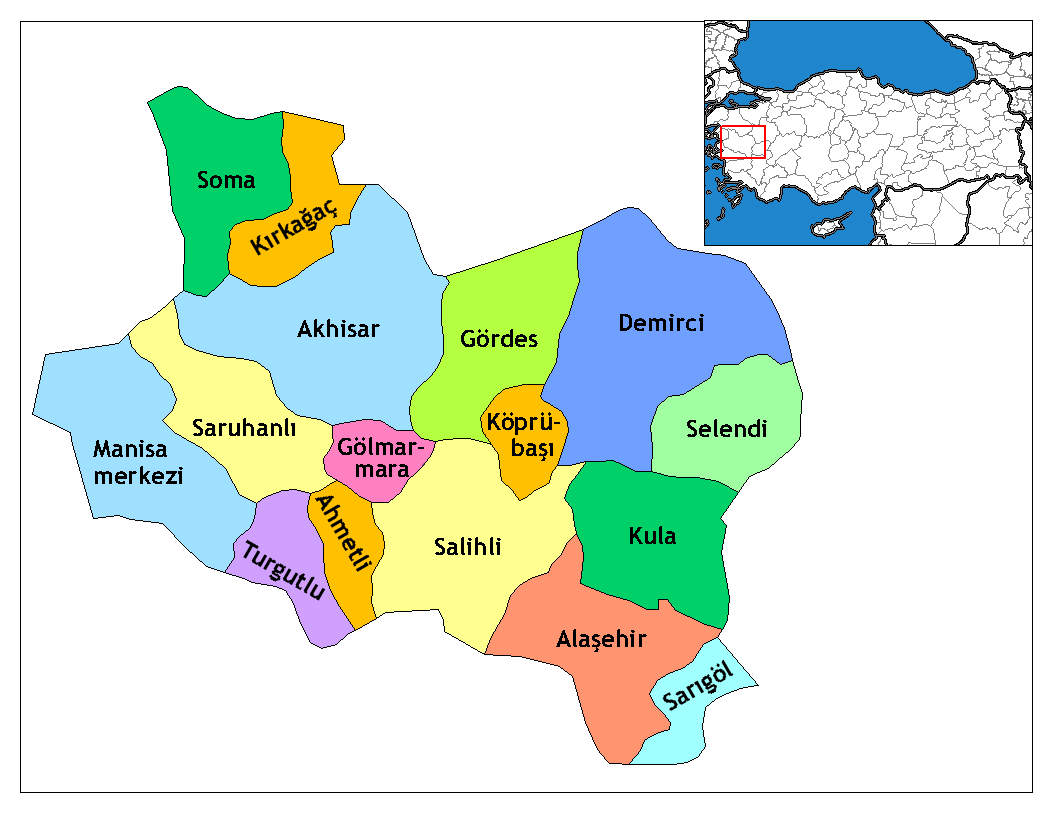
- Created by Rarelibra 16:36, 4 December 2006 (UTC) for public domain use, using MapInfo Professional v8.5 and various mapping resources.
- Edited by One Homo Sapiens Corrected text where İ,Ş,ı,ğ,or ş occurs in name. Source: [statoids-com]. Increased font size and enhanced color differences among adjacent districts.
Licence[labot šo sadaļu]
| I, the copyright holder of this work, release this work into the public domain. This applies worldwide. In some countries this may not be legally possible; if so: I grant anyone the right to use this work for any purpose, without any conditions, unless such conditions are required by law. |
Faila hronoloģija
Uzklikšķini uz datums/laiks kolonnā esošās saites, lai apskatītos, kā šis fails izskatījās tad.
| Datums/Laiks | Attēls | Izmēri | Dalībnieks | Komentārs | |
|---|---|---|---|---|---|
| tagadējais | 2008. gada 29. decembris, plkst. 01.35 | | 1 056 × 816 (40 KB) | One Homo Sapiens (diskusija | devums) | Corrected text where İ,Ş,ı,ğ,or ş occurs in name. Source: [statoids-com]. Increased font size and enhanced color differences among adjacent districts. |
| 2006. gada 4. decembris, plkst. 16.36 |  | 1 056 × 816 (35 KB) | Rarelibra (diskusija | devums) | Map of the districts of Manisa province in Turkey. Created by ~~~~ for public domain use, using MapInfo Professional v8.5 and various mapping resources. |
Šo failu nevar pārrakstīt.
Faila lietojums
Šo failu izmanto šajās 7 lapās:
Globālais faila lietojums
Šīs Vikipēdijas izmanto šo failu:
- Izmantojums ar.wikipedia.org
- Izmantojums arz.wikipedia.org
- Izmantojums ast.wikipedia.org
- Izmantojums azb.wikipedia.org
- Izmantojums az.wikipedia.org
- Izmantojums ca.wikipedia.org
- Izmantojums ceb.wikipedia.org
- Izmantojums ce.wikipedia.org
- Izmantojums cs.wikipedia.org
- Izmantojums diq.wikipedia.org
- Izmantojums en.wikipedia.org
- Izmantojums en.wiktionary.org
- Izmantojums eo.wikipedia.org
Skatīt šī faila pilno globālo izmantojumu.