File:Manowo (gmina) location map.png
Jump to navigation
Jump to search
Size of this preview: 639 × 600 pixels. Other resolutions: 256 × 240 pixels | 511 × 480 pixels | 851 × 799 pixels.
Original file (851 × 799 pixels, file size: 115 KB, MIME type: image/png)
Captions
Captions
Add a one-line explanation of what this file represents
| Description |
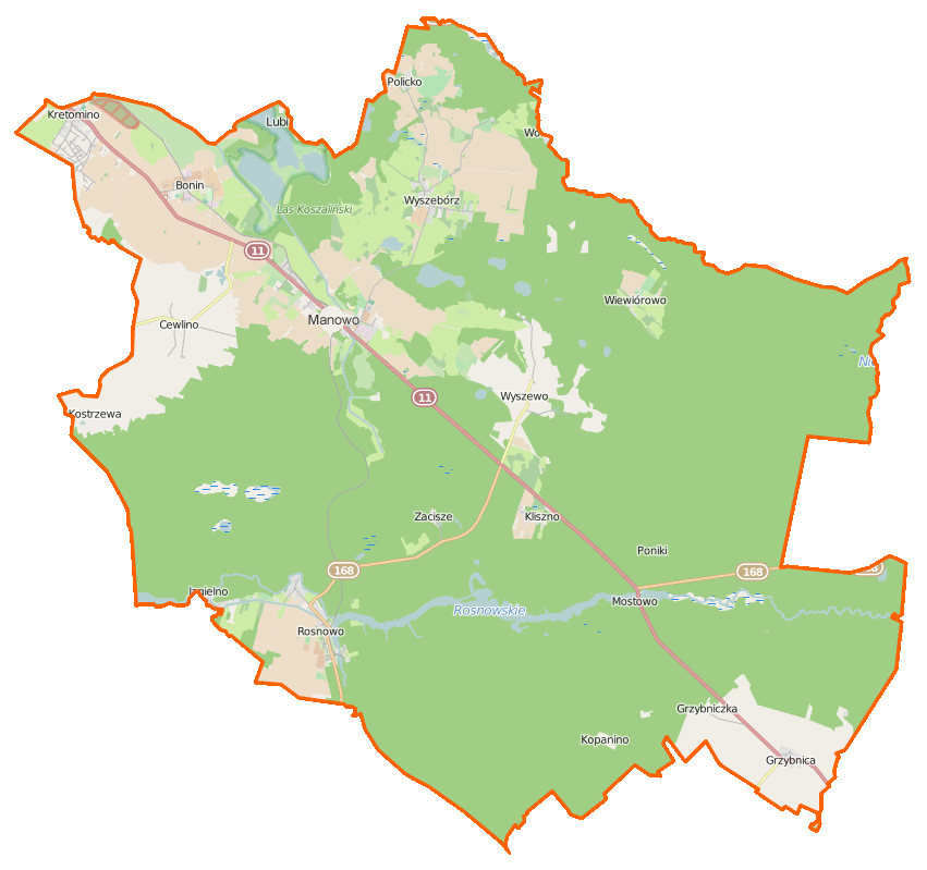
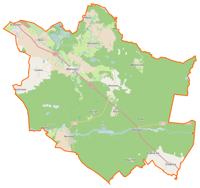
Polski: Mapa gminy Manowo, Polska
English: Map of Gmina Manowo, Poland |
|||||||||
| Date | ||||||||||
| Source | You may find a page on the OpenStreetMap wiki page for Manowo (gmina) | |||||||||
| Creator |
OpenStreetMap contributors OpenStreetMap contributors |
|||||||||
| Permission (Reusing this file) |
OpenStreetMap data is available under the Open Database License (details). Map tiles are licensed under the Creative Commons Attribution-ShareAlike 2.0 license (CC-BY-SA 2.0).
This file is licensed under the Creative Commons Attribution-Share Alike 2.0 Generic license.
|
|||||||||
| Geotemporal data | ||||||||||
| Bounding box |
|
|||||||||
| Georeferencing | If inappropriate please set warp_status = skip to hide. | |||||||||
File history
Click on a date/time to view the file as it appeared at that time.
| Date/Time | Thumbnail | Dimensions | User | Comment | |
|---|---|---|---|---|---|
| current | 13:46, 26 March 2015 | | 851 × 799 (115 KB) | VanWiel (talk | contribs) | {{OpenStreetMap | name = Manowo (gmina) | location = Manowo (gmina) | description = {{pl|Mapa gminy Manowo, Polska}} {{en|Map of Gmina Manowo, Poland}} | top = 54.1849 | bottom = 54.0240 | left... |
You cannot overwrite this file.
File usage on Commons
There are no pages that use this file.
File usage on other wikis
The following other wikis use this file:
- Usage on fr.wikipedia.org
- Manowo
- Bonin (Koszalin)
- Cewlino
- Dęborogi
- Gajewo (Koszalin)
- Grąpa
- Grzybnica (Koszalin)
- Grzybniczka
- Jagielno (Poméranie-Occidentale)
- Kliszno
- Kopanica (Poméranie-Occidentale)
- Kopanino (Poméranie-Occidentale)
- Kostrzewa (Koszalin)
- Kretomino
- Lisowo (Koszalin)
- Mostowo (Poméranie-Occidentale)
- Policko (Koszalin)
- Poniki (Poméranie-Occidentale)
- Rosnowo (Koszalin)
- Wiewiórowo
- Wyszebórz
- Wyszewo
- Zacisze (Koszalin)
- Usage on pl.wikipedia.org
- Manowo (gmina)
- Rosnowo (powiat koszaliński)
- Cewlino
- Grzybnica (powiat koszaliński)
- Manowo
- Wyszebórz
- Wyszewo
- Bonin (powiat koszaliński)
- Mostowo (województwo zachodniopomorskie)
- Wiewiórowo
- Dęborogi
- Kopanino (województwo zachodniopomorskie)
- Policko (powiat koszaliński)
- Gajewo (powiat koszaliński)
- Grąpa
- Grzybniczka
- Jagielno (województwo zachodniopomorskie)
- Kliszno
- Kopanica (województwo zachodniopomorskie)
- Kostrzewa (powiat koszaliński)
- Lisowo (powiat koszaliński)
- Poniki (województwo zachodniopomorskie)
- Zacisze (powiat koszaliński)
- Lubiatowo Północne
- Wyszewka
- Bonin (przystanek kolejowy)
- Manowo (stacja kolejowa)
View more global usage of this file.
_location_map.png)
_location_map.png&oldid=519976915)