File:Mansfeld geological map2 300dpi.jpg
Jump to navigation
Jump to search

Size of this preview: 800 × 463 pixels. Other resolutions: 320 × 185 pixels | 640 × 371 pixels | 1,024 × 593 pixels | 1,280 × 741 pixels | 2,560 × 1,482 pixels | 13,299 × 7,699 pixels.
Original file (13,299 × 7,699 pixels, file size: 4.23 MB, MIME type: image/jpeg)
Captions
Captions
Add a one-line explanation of what this file represents
Summary
[edit]
| Warning | The original file is very high-resolution. It might not load properly or could cause your browser to freeze when opened at full size. |
|---|
| Description |
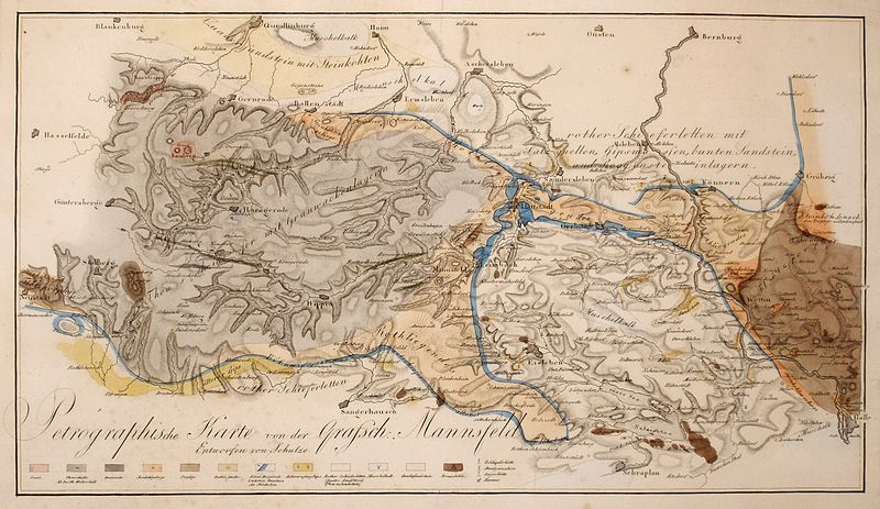
Deutsch: Petrographische Karte von der Grafschaft Mannsfeld. Schulze 1815, Kupferst koloriert / Foto: Benutzer:Lysippos |
| Date | |
| Source |
(Original text: selbst fotografiert) Geognostische Arbeiten / von Johann Carl Freiesleben: Bd. 3: : Geognostischer Beytrag zur Kenntniß des Kupferschiefergebirges, mit besonderer Hinsicht auf einen Theil der Graffschaft Mansfeld und Thüringens; mit 1 Kupfer u. 1 illuminirten petrographischen Charte. show here |
| Author | Schulze, 1815 show here |
Licensing
[edit]
| I, the copyright holder of this work, release this work into the public domain. This applies worldwide. In some countries this may not be legally possible; if so: I grant anyone the right to use this work for any purpose, without any conditions, unless such conditions are required by law. |
Original upload log
[edit]
Transferred from de.wikipedia to Commons by Pomfuttge using CommonsHelper.
The original description page was here. All following user names refer to de.wikipedia.
- 2008-05-25 10:21 Lysippos 13299×7699× (4437251 bytes) {{Information |Beschreibung = Petrographische Karte der Grafschaft Mannsfeld (Schulze 1815) |Quelle = selbst fotografiert |Urheber = ~~~~ |Datum = 2008 |Genehmigung = |Andere Versionen = |Anmerkungen = }}
File history
Click on a date/time to view the file as it appeared at that time.
| Date/Time | Thumbnail | Dimensions | User | Comment | |
|---|---|---|---|---|---|
| current | 23:05, 3 January 2011 | | 13,299 × 7,699 (4.23 MB) | File Upload Bot (Magnus Manske) (talk | contribs) | {{BotMoveToCommons|de.wikipedia|year={{subst:CURRENTYEAR}}|month={{subst:CURRENTMONTHNAME}}|day={{subst:CURRENTDAY}}}} {{Information |Description={{de|Petrographische Karte der Grafschaft Mannsfeld (Schulze 1815)}} |Source=Transferred from [http://de.wik |
You cannot overwrite this file.
File usage on Commons
There are no pages that use this file.
File usage on other wikis
The following other wikis use this file:
- Usage on azb.wikipedia.org
- Usage on de.wikipedia.org