File:Manukau County (1918) (Pohutukawa Coast).jpg
Original file (661 × 604 pixels, file size: 84 KB, MIME type: image/jpeg)
Captions
Captions
Summary
[edit]| Description |
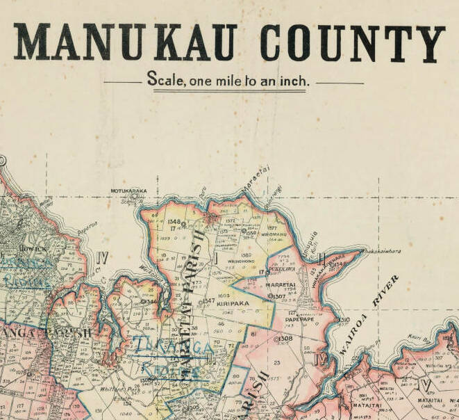
English: A cadastral map of Manukau County showing boundaries with Eden County to the north-west and Franklin County to the south; also boundaries with Otahuhu Borough and Howick, Papatoitoi [Papatoetoe], Manurewa and Papakura town districts. Shows the Pakuranga, Manurewa, Papakura, Maraetai and Taupo survey parishes.
The original map belonged to Manukau County councillor James Montgomerie (1922-1923). The boundaries of Manukau County's electoral divisions (Mangere, Papatoetoe, Pakuranga, Turanga, Papakura and Wairoa Ridings) have been hand-drawn in blue; town district boundaries have been outlined in red. Auckland Libraries Heritage Collections Map 9314 |
| Date | |
| Source | https://kura.aucklandlibraries.govt.nz/digital/collection/maps/id/9101 |
| Author | Department of Lands and Survey |
| Other versions |
.jpg)
_(Pohutukawa_Coast).jpg&action=edit§ion=1)
Licensing
[edit]_(Pohutukawa_Coast).jpg&action=edit§ion=2)
|
This work is in the public domain in its country of origin and other countries and areas where the copyright term is the author's life plus 70 years or fewer. This work is in the public domain in the United States because it was published (or registered with the U.S. Copyright Office) before January 1, 1929. | |
| This file has been identified as being free of known restrictions under copyright law, including all related and neighboring rights. | |
File history
Click on a date/time to view the file as it appeared at that time.
| Date/Time | Thumbnail | Dimensions | User | Comment | |
|---|---|---|---|---|---|
| current | 06:45, 19 June 2023 | | 661 × 604 (84 KB) | Prosperosity (talk | contribs) | File:Manukau County (1918).jpg cropped 67 % horizontally, 53 % vertically using CropTool with precise mode. |
You cannot overwrite this file.
File usage on Commons
The following page uses this file:
_(Pohutukawa_Coast).jpg&oldid=777209539)