File:Map of comune of Alta Val Tidone (province of Piacenza, region Emilia-Romagna, Italy).svg
Jump to navigation
Jump to search

Size of this PNG preview of this SVG file: 650 × 599 pixels. Other resolutions: 260 × 240 pixels | 521 × 480 pixels | 833 × 768 pixels | 1,111 × 1,024 pixels | 2,222 × 2,048 pixels | 4,145 × 3,821 pixels.
Original file (SVG file, nominally 4,145 × 3,821 pixels, file size: 107 KB)
Captions
Captions
Add a one-line explanation of what this file represents
Summary
[edit].svg&action=edit§ion=1)
| Description |
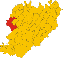
English: Map of the municipality (comune) of Alta Val Tidone (province of Piacenza, region Emilia-Romagna, Italy) |
||
| Date | |||
| Source |
This file was derived from: Map of ex-comune of Pecorara (province of Piacenza, region Emilia-Romagna, Italy).svg: |
||
| Author |
Original: Vonvikken, from Map of ex-comune of Pecorara (province of Piacenza, region Emilia-Romagna, Italy).svg Derivative work: Krepideia |
||
| Permission (Reusing this file) |
|
||
| SVG development | This vector image was created with Inkscape. |
.svg)
.svg)
File history
Click on a date/time to view the file as it appeared at that time.
| Date/Time | Thumbnail | Dimensions | User | Comment | |
|---|---|---|---|---|---|
| current | 13:07, 31 December 2017 | | 4,145 × 3,821 (107 KB) | Krepideia (talk | contribs) | User created page with UploadWizard |
You cannot overwrite this file.
File usage on Commons
The following page uses this file:
File usage on other wikis
The following other wikis use this file:
- Usage on bg.wikipedia.org
- Usage on el.wikipedia.org
- Usage on fr.wikipedia.org
- Usage on it.wikipedia.org
- Usage on ja.wikipedia.org
- Usage on la.wikipedia.org
- Usage on lmo.wikipedia.org
- Usage on nl.wikipedia.org
- Usage on pms.wikipedia.org
- Usage on sv.wikipedia.org
- Usage on www.wikidata.org
.svg&oldid=458414292)