File:Map-Germany-1945.svg
De Wikimedia Commons
Salta a la navegació
Salta a la cerca

Mida d'aquesta previsualització PNG del fitxer SVG: 706 × 600 píxels. Altres resolucions: 283 × 240 píxels | 565 × 480 píxels | 904 × 768 píxels | 1.206 × 1.024 píxels | 2.411 × 2.048 píxels | 3.492 × 2.966 píxels.
Fitxer original (fitxer SVG, nominalment 3.492 × 2.966 píxels, mida del fitxer: 726 Ko)
Informació del fitxer
Dades estructurades
Llegendes
Llegendes
Afegeix una explicació d'una línia del que representa aquest fitxer
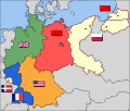
Occupation map of Germany after WW2
Carte de l'oocupation de l'Allemagne par les alliés de l'entente après le seconde guerre mondiale
Оккупационные зоны Нацисткой Германии после войны
第二次世界大戦後のドイツの占領地図
Resum
[modifica]| DescripcióMap-Germany-1945.svg |
العربية: حدود المناطق المحتلة في ألمانيا عام 1957. الاراضي شرق خط نيس تحت السيطرة البولندية والسوفييتية، تظهر بلون ابيض. برلين منطقة مسيطر عليها من عدة بلدان داخل المنطقة السوفييتة. English: Occupation zone borders in Germany, 1947. The territories east of the Oder-Neisse line, under Polish and Soviet administration/annexation, are shown as cream as is the likewise detached Saar protectorate. Berlin is the multinational area within the Soviet zone. Français : Carte des zones d'occupation de l'Allemagne : le protectorat français de la Sarre apparait en blanc-crème, comme la Silésie, la Poméranie et les autres régions allemandes orientales annexées par la Pologne et l'Union Soviétique. Deutsch: Grenzen der Besatzungszonen in Deutschland, 1947. Die Gebiete östlich der Oder-Neiße-Grenze, unter polnischer und sowjetischer Verwaltung/Annexion, sowie das Saar-Protektorat sind cremefarben dargestellt. Berlin ist ein multinationales Gebiet inmitten der sowjetischen Besatzungszone. |
| Data |
17 de març de 2008 (original upload date) |
| Font | Based on map data of the IEG-Maps project (Andreas Kunz, B. Johnen and Joachim Robert Moeschl: University of Mainz) - www.ieg-maps.uni-mainz.de. |
| Autor | User:52 Pickup |
| SVG genesis InfoField | El codi font d’aquest SVG no és vàlid perquè hi 11 han errors. Aquesta imatge vectorial ha estat creada amb Inkscape. |
Llicència
[modifica]Aquest fitxer està publicat sota la llicència de Creative Commons Reconeixement i Compartir Igual 2.5 Genèrica.
- Sou lliure de:
- compartir – copiar, distribuir i comunicar públicament l'obra
- adaptar – fer-ne obres derivades
- Amb les condicions següents:
- reconeixement – Heu de donar la informació adequada sobre l'autor, proporcionar un enllaç a la llicència i indicar si s'han realitzat canvis. Podeu fer-ho amb qualsevol mitjà raonable, però de cap manera no suggereixi que l'autor us dóna suport o aprova l'ús que en feu.
- compartir igual – Si modifiqueu, transformeu, o generareu amb el material, haureu de distribuir les vostres contribucions sota una llicència similar o una de compatible com l'original
Registre original de càrregues
[modifica]Transferred from en.wikipedia to Commons by Broadbeer using CommonsHelper.
La pàgina de descripció original era aquí. Els noms d'usuari a continuació es refereixen a en.wikipedia.
- 2008-03-17 19:50 52 Pickup 3492×2966× (760290 bytes) Changes to fill and border colours. Made differences clearer between occupation zones and eventual territorial losses.
- 2007-08-31 14:57 52 Pickup 3492×2966× (755561 bytes) New version: regions placed under Polish and Soviet administration now presented slightly differently (borders instead of colour fill), Saar colour now only slightly different to French zone (still needs some work)
- 2007-08-10 09:50 52 Pickup 3492×2966× (751829 bytes) oops, now with fixed image size
- 2007-08-10 09:47 52 Pickup 744×1052× (751774 bytes) {{Information| |Description= Germany in the aftermath of World War II: 1 September 1945 |Source= Based on map data of the IEG-Maps project (Andreas Kunz, B. Johnen and Joachim Robert Moeschl: University of Mainz) - [http://www.ieg-maps.uni-mainz.de www.ie
| Anotacions InfoField | Aquesta imatge té anotacions: Vegeu-les a Commons |
1548
1117
208
153
3492
2966
Historial del fitxer
Cliqueu una data/hora per veure el fitxer tal com era aleshores.
| Data/hora | Miniatura | Dimensions | Usuari/a | Comentari | |
|---|---|---|---|---|---|
| actual | 04:37, 1 des 2017 |  | 3.492 × 2.966 (726 Ko) | Sammimack (discussió | contribucions) | Updated flags and colours |
| 14:13, 3 jul 2015 |  | 3.492 × 2.966 (728 Ko) | Lichaosheng (discussió | contribucions) | New 48-Star US Flag from File:US flag 48 stars.svg | |
| 14:00, 3 jul 2015 |  | 3.492 × 2.966 (742 Ko) | Lichaosheng (discussió | contribucions) | Reverted to version as of 18:46, 8 October 2008 | |
| 15:19, 4 feb 2012 |  | 3.492 × 2.966 (742 Ko) | AnonMoos (discussió | contribucions) | Reverted to version as of 18:46, 8 October 2008 -- Kaliningrad had quite different status and fate from that of East Germany proper... | |
| 19:44, 20 gen 2012 |  | 3.492 × 2.966 (742 Ko) | Sammy pompon (discussió | contribucions) | Kaliningrado is occuped by USSR. | |
| 18:46, 8 oct 2008 |  | 3.492 × 2.966 (742 Ko) | File Upload Bot (Magnus Manske) (discussió | contribucions) | {{BotMoveToCommons|en.wikipedia}} {{Information |Description={{en|Occupation zone borders in Germany, 1947. The territories east of the en:Oder-Neisse line, under Polish and Soviet administration/annexation, are shown as white as is the likewise det |
No podeu sobreescriure aquest fitxer.
Ús del fitxer
Les 3 pàgines següents utilitzen aquest fitxer:
Ús global del fitxer
Utilització d'aquest fitxer en altres wikis:
- Utilització a af.wikipedia.org
- Utilització a ar.wikipedia.org
- Utilització a arz.wikipedia.org
- Utilització a ast.wikipedia.org
- Utilització a azb.wikipedia.org
- Utilització a az.wikipedia.org
- Utilització a be.wikipedia.org
- Utilització a bs.wikipedia.org
- Utilització a ca.wikipedia.org
- Utilització a ckb.wikipedia.org
- Utilització a cs.wikipedia.org
- Utilització a cy.wikipedia.org
- Utilització a da.wikipedia.org
- Utilització a de.wikipedia.org
- Utilització a de.wikibooks.org
- Utilització a el.wikipedia.org
- Utilització a en.wikipedia.org
Vegeu més usos globals d'aquest fitxer.
Metadades
Aquest fitxer conté informació addicional, probablement afegida per la càmera digital o l'escàner utilitzat per a crear-lo o digitalitzar-lo. Si s'ha modificat posteriorment, alguns detalls poden no reflectir les dades reals del fitxer modificat.
| Amplada | 3491.9761 |
|---|---|
| Alçària | 2965.8201 |
