File:Map-of-Ottoman-Empire-in-1900-German.svg
跳至導覽
跳至搜尋

此 SVG 檔案的 PNG 預覽的大小:800 × 502 像素。 其他解析度:320 × 201 像素 | 640 × 401 像素 | 1,024 × 642 像素 | 1,280 × 803 像素 | 2,560 × 1,605 像素 | 2,647 × 1,660 像素。
原始檔案 (SVG 檔案,表面大小:2,647 × 1,660 像素,檔案大小:82 KB)
說明
說明
添加單行說明來描述出檔案所代表的內容
| 描述 |
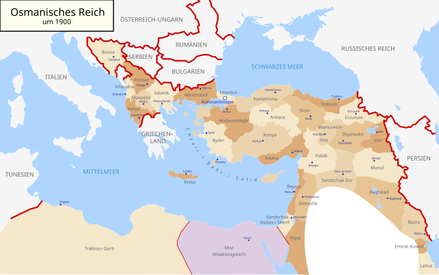
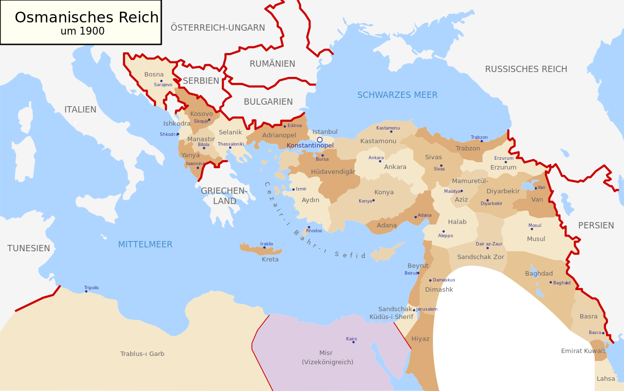
Deutsch: Karte des Osmanischen Reiches um 1900 in Deutsch
English: Map of Ottoman Empire (1900) in German |
| 日期 | (UTC) |
| 來源 | |
| 作者 |
|
| 其他版本 |
Map-of-Ottoman-Empire-in-1900-German.svg[]
Derivative works of this file: |


.svg)
.jpg)
我,本作品的著作權持有者,決定用以下授權條款發佈本作品:
| 我,此作品的版權所有人,釋出此作品至公共領域。此授權條款在全世界均適用。 這可能在某些國家不合法,如果是的話: 我授予任何人有權利使用此作品於任何用途,除受法律約束外,不受任何限制。 |
原始上傳日誌
[編輯]
This image is a derivative work of the following images:
- File:Map-of-Ottoman-Empire-in-1900-Latvian.svg licensed with PD-self
- 2008-01-30T21:53:09Z Juristiltins 885x557 (105823 Bytes) {{Information |Description=Map of Ottoman Empire (1900) in Latvian |Source=own work |Date=30 January 2008 |Author=Juris Tiltins |Permission=Free use and distribution permitted. |other_versions= }} [[Category:Maps of the Ottom
Uploaded with derivativeFX
檔案歷史
點選日期/時間以檢視該時間的檔案版本。
| 日期/時間 | 縮圖 | 尺寸 | 用戶 | 備註 | |
|---|---|---|---|---|---|
| 目前 | 2018年5月18日 (五) 09:25 | | 2,647 × 1,660(82 KB) | NordNordWest(對話 | 貢獻) | corr |
| 2010年9月15日 (三) 16:03 |  | 2,647 × 1,660(79 KB) | NordNordWest(對話 | 貢獻) | c | |
| 2010年9月15日 (三) 16:01 |  | 2,646 × 1,660(79 KB) | NordNordWest(對話 | 貢獻) | c | |
| 2010年9月15日 (三) 16:00 |  | 2,646 × 1,660(79 KB) | NordNordWest(對話 | 貢獻) | c | |
| 2010年8月28日 (六) 18:30 |  | 2,645 × 1,661(112 KB) | NordNordWest(對話 | 貢獻) | bigger | |
| 2010年8月28日 (六) 18:18 |  | 885 × 557(96 KB) | NordNordWest(對話 | 貢獻) | {{Information |Description={{de|Karte des Osmanischen Reiches um 1900 in Deutsch}} {{en|Map of Ottoman Empire (1900) in German}} |Source=*File:Map-of-Ottoman-Empire-in-1900-Latvian.svg |Date=2010-08-28 18:18 (UTC) |Author=*[[:File:Map-of-Ottoman-Emp |
無法覆蓋此檔案。
檔案用途
下列8個頁面有用到此檔案:
- User:J budissin/Uploads/BiH/2018 May 11-20
- File:1908 Meclis-i Mebusân members by vilayet (or sanjak) and ethnicity.svg
- File:Map-of-Ottoman-Empire-in-1900-German.svg
- File:Map-of-Ottoman-Empire-in-1900-Latvian.svg
- File:Map-of-Ottoman-Empire-in-1900-Spanish.svg
- File:Map-of-Ottoman-Empire-in-1900.png
- File:Map of Ottoman Empire in 1900-hu.svg
- Template:Other versions/Map of Ottoman Empire (1900)
_and_ethnicity.svg)
全域檔案使用狀況
以下其他 wiki 使用了這個檔案:
- af.wikipedia.org 的使用狀況
- als.wikipedia.org 的使用狀況
- cy.wikipedia.org 的使用狀況
- de.wikipedia.org 的使用狀況
- en.wikipedia.org 的使用狀況
- he.wikipedia.org 的使用狀況
- it.wikipedia.org 的使用狀況
- lv.wikipedia.org 的使用狀況
- no.wikipedia.org 的使用狀況
- pl.wikipedia.org 的使用狀況
- pnb.wikipedia.org 的使用狀況
- ru.wikipedia.org 的使用狀況
- sk.wikipedia.org 的使用狀況
- sr.wikipedia.org 的使用狀況
- sv.wikipedia.org 的使用狀況
- tr.wikipedia.org 的使用狀況
- ur.wikipedia.org 的使用狀況