File:Map-saxony1900.png
Jump to navigation
Jump to search

Size of this preview: 800 × 556 pixels. Other resolutions: 320 × 222 pixels | 640 × 445 pixels | 1,024 × 711 pixels | 1,280 × 889 pixels | 2,560 × 1,779 pixels | 3,653 × 2,538 pixels.
Original file (3,653 × 2,538 pixels, file size: 115 KB, MIME type: image/png)
Captions
Captions
Add a one-line explanation of what this file represents
Summary
[edit]
| Description |
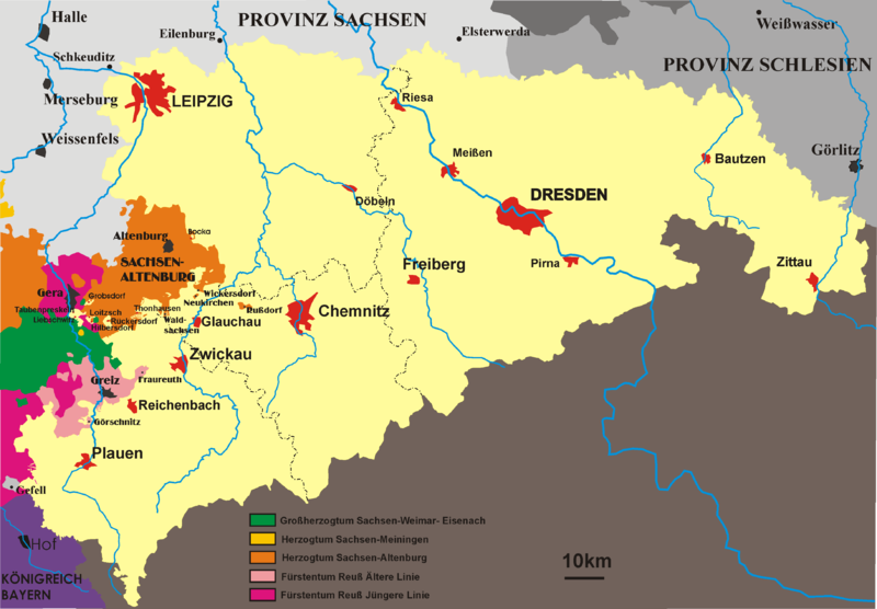
Map of kingdom Saxony in the 19th century 1815-1918 self made by störfix |
| Date | 2 September 2005 (original upload date) |
| Source | No machine-readable source provided. Own work assumed (based on copyright claims). |
| Author | No machine-readable author provided. Störfix assumed (based on copyright claims). |
Licensing
[edit]
| I, the copyright holder of this work, release this work into the public domain. This applies worldwide. In some countries this may not be legally possible; if so: I grant anyone the right to use this work for any purpose, without any conditions, unless such conditions are required by law. |
ehemals Bild:Karte-Sachsen.png
Karte Königreich Sachsen selbst gezeichnet Gemeinfrei
Bei Korrekturen bitte mir Bescheid sagen, damit ich die Zeichnung auf dem aktuellen Stand habe
File history
Click on a date/time to view the file as it appeared at that time.
| Date/Time | Thumbnail | Dimensions | User | Comment | |
|---|---|---|---|---|---|
| current | 23:32, 19 July 2014 | | 3,653 × 2,538 (115 KB) | Kopiersperre (talk | contribs) | -75 % filesize |
| 17:19, 1 February 2008 |  | 3,653 × 2,538 (459 KB) | Jungpionier (talk | contribs) | Meissen -> Meißen ("Meissen" ist nur die Bezeichnung des Porzellans, ansonsten wird die Stadt mit "ß" geschrieben) | |
| 20:50, 2 September 2005 |  | 3,653 × 2,538 (298 KB) | Störfix (talk | contribs) | Map of kingdom Saxony in the 19th century 1806-1918 self made by störfix |
You cannot overwrite this file.
File usage on Commons
There are no pages that use this file.
File usage on other wikis
The following other wikis use this file:
- Usage on be.wikipedia.org
- Usage on bg.wikipedia.org
- Usage on br.wikipedia.org
- Usage on ca.wikipedia.org
- Usage on da.wikipedia.org
- Usage on de.wikipedia.org
- Usage on de.wikisource.org
- Usage on el.wikipedia.org
- Usage on en.wikipedia.org
- Usage on es.wikipedia.org
- Usage on et.wikipedia.org
- Usage on fr.wikipedia.org
- Usage on hr.wikipedia.org
- Usage on hu.wikipedia.org
- Usage on id.wikipedia.org
- Usage on it.wikipedia.org
- Usage on ja.wikipedia.org
- Usage on li.wikipedia.org
- Usage on lv.wikipedia.org
- Usage on mk.wikipedia.org
- Usage on mn.wikipedia.org
- Usage on nl.wikipedia.org
- Usage on no.wikipedia.org
- Usage on pl.wikipedia.org
- Usage on ru.wikipedia.org
- Usage on sl.wikipedia.org
- Usage on th.wikipedia.org
- Usage on tr.wikipedia.org
- Usage on uk.wikipedia.org
- Usage on www.wikidata.org