File:Map10.jpg
Spring til navigation
Spring til søgning

Størrelse af denne forhåndsvisning: 752 × 599 pixels. Andre opløsninger: 301 × 240 pixels | 602 × 480 pixels | 882 × 703 pixels.
Oprindelig fil (882 × 703 billedpunkter, filstørrelse: 216 KB, MIME-type: image/jpeg)
Captions
Captions
Tilføj en kort forklaring på en enkelt linje om hvad filen viser
Beskrivelse
[redigér]
| Beskrivelse | |
| Dato | |
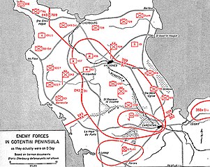
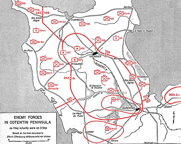
| Kilde | Utah Beach to Cherbourg (6 June-27 June 1944). Washington, Historical Division, Department of the Army, 1947. Immediate source: www.history.army.mil, Map 10 |
| Forfatter | Historical Division, Department of the Army |
Licensering
[redigér]
This file is a work of a U.S. Army soldier or employee, taken or made as part of that person's official duties. As a work of the U.S. federal government, it is in the public domain in the United States.
|
 |
derivative works
[redigér]
Derivative works of this file: Normandy.1944.001.uk.svg
Filhistorik
Klik på en dato/tid for at se filen som den så ud på det tidspunkt.
| Dato/tid | Miniaturebillede | Dimensioner | Bruger | Kommentar | |
|---|---|---|---|---|---|
| nuværende | 20. jul. 2015, 13:48 | | 882 × 703 (216 KB) | Hohum (diskussion | bidrag) | Colour units for clarity |
| 6. jan. 2006, 16:51 |  | 882 × 703 (151 KB) | John N. (diskussion | bidrag) | * Description: Map of german positions on cotentin penisula, D-Day * Source: http://www.army.mil/cmh-pg/books/wwii/utah/maps/Map10.jpg == Licensing == {{PD-USArmy}} |
Du kan ikke overskrive denne fil.
Filanvendelse
De følgende 4 sider bruger denne fil:
Global filanvendelse
Følgende andre wikier anvender denne fil:
- Anvendelser på ar.wikipedia.org
- Anvendelser på bg.wikipedia.org
- Anvendelser på ca.wikipedia.org
- Anvendelser på cs.wikipedia.org
- Anvendelser på da.wikipedia.org
- Anvendelser på de.wikipedia.org
- Anvendelser på en.wikipedia.org
- Anvendelser på es.wikipedia.org
- Anvendelser på ga.wikipedia.org
- Anvendelser på ja.wikipedia.org
- Anvendelser på nl.wikipedia.org
- Anvendelser på pl.wikipedia.org
- Anvendelser på ru.wikipedia.org
- Anvendelser på uk.wikipedia.org
- Anvendelser på vi.wikipedia.org
- Anvendelser på www.wikidata.org