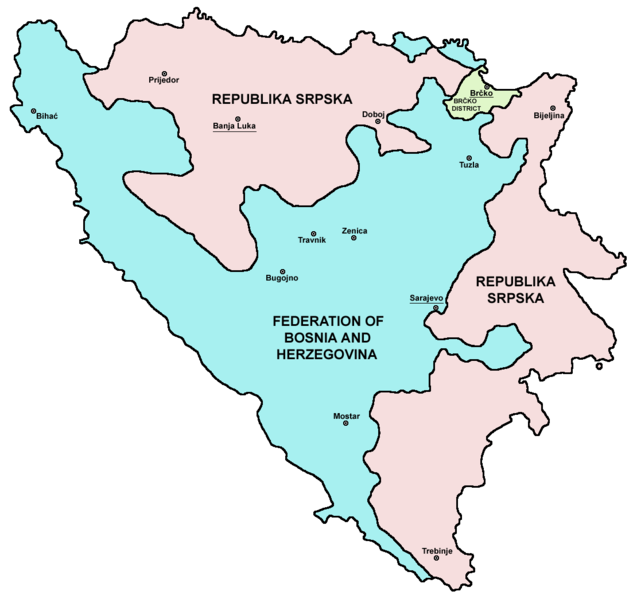
File:Map Bih entities.png
No ''Wikimedia Commons''
Pāriet uz navigāciju
Pāriet uz meklēšanu

Šī priekšskata izmērs: 633 × 599 pikseļi. Citi izmēri: 254 × 240 pikseļi | 507 × 480 pikseļi | 811 × 768 pikseļi | 1 103 × 1 044 pikseļi.
Sākotnējais fails (1 103 × 1 044 pikseļi, faila izmērs: 67 KB, MIME tips: image/png)
Faila informācija
Strukturētie dati
Captions
Captions
Pievieno vienas rindiņas aprakstu, ko šis fails attēlo
Kopsavilkums[labot šo sadaļu]
| AprakstsMap Bih entities.png |
Srpskohrvatski / српскохрватски: Federacija Bosne i Hercegovine, Republika Srpska i Distrikt Brčko / Федерација Босне и Херцеговине, Република Српска и Дистрикт Брчко. |
| Datums | |
| Avots | en:Image:M_bih03.png |
| Autors | User:PANONIAN |
| Citas versijas |
|
References[labot šo sadaļu]
- Slobodan Radovanović, Geografski atlas, Magic Map, Smederevska Palanka, 2001.
- Geografski atlas, Intersistem kartografija, Beograd, 2004.
- http://www.mapsofworld.com/bosnia/maps/bosnia-herzegovina-map.jpg
- http://www.slobodanjovanovic.org/wp-content/uploads/2009/12/bosna-kantoni1.jpg
- http://www.thomasgraz.net/glass/map-BIH.gif
- http://aceproject.org/ero-en/regions/europe/BA/doc1.jpg/image
- United States Department of State
- http://www.visitbosnia.org/bih/images/stories/o_bih/drzavno_uredjenje/entiteti.jpg[dead link]
- http://www.conflictgeographies.org/uploads/2/6/1/8/2618869/8958714.jpg?490 archive copy at the Wayback Machine
- http://vozi.org/images/stories/broj%20registrovanih%20vozila%202010.godina.png
- http://www.ohr.int/ohr-offices/brcko/images/map-brcko-district.jpg
- http://www.ohr.int/ohr-offices/brcko/images/mapa%20BD.JPG
- http://www.conflictgeographies.org/uploads/2/6/1/8/2618869/388168.jpg?490 archive copy at the Wayback Machine
- http://world-gazetteer.com/ archive copy at the Wayback Machine
Licence[labot šo sadaļu]
| Public domainPublic domainfalsefalse |
| I, the copyright holder of this work, release this work into the public domain. This applies worldwide. In some countries this may not be legally possible; if so: I grant anyone the right to use this work for any purpose, without any conditions, unless such conditions are required by law. |

|
This map image could be re-created using vector graphics as an SVG file. This has several advantages; see Commons:Media for cleanup for more information. If an SVG form of this image is available, please upload it and afterwards replace this template with
{{vector version available|new image name}}.
It is recommended to name the SVG file “Map Bih entities.svg”—then the template Vector version available (or Vva) does not need the new image name parameter. |
Faila hronoloģija
Uzklikšķini uz datums/laiks kolonnā esošās saites, lai apskatītos, kā šis fails izskatījās tad.
| Datums/Laiks | Attēls | Izmēri | Dalībnieks | Komentārs | |
|---|---|---|---|---|---|
| tagadējais | 2010. gada 6. jūlijs, plkst. 21.38 |  | 1 103 × 1 044 (67 KB) | PANONIAN (diskusija | devums) | Reverted to version as of 23:51, 12 March 2010 - I do not agree that these are better colours. it is subjective opinion and it is bad idea that every user should upload new file version because he have different opinion about "better" colours |
| 2010. gada 6. jūlijs, plkst. 12.26 |  | 1 103 × 1 044 (58 KB) | Mostarac (diskusija | devums) | better colors | |
| 2010. gada 6. jūlijs, plkst. 12.25 |  | 1 103 × 1 044 (58 KB) | Mostarac (diskusija | devums) | better colors and cities. | |
| 2010. gada 12. marts, plkst. 23.51 |  | 1 103 × 1 044 (67 KB) | Dungodung (diskusija | devums) | Well, I beg to differ. This one shows cities and is of better quality | |
| 2010. gada 9. marts, plkst. 11.55 |  | 700 × 615 (172 KB) | Mostarac (diskusija | devums) | revert, bolje boje! | |
| 2009. gada 20. decembris, plkst. 21.10 |  | 1 103 × 1 044 (67 KB) | PANONIAN (diskusija | devums) | improved version | |
| 2007. gada 16. jūlijs, plkst. 08.05 |  | 700 × 615 (13 KB) | Nihad Hamzic (diskusija | devums) | This image was once a JPEG, the author had simply directly converted it to JPEG. I have grealty optimised its size by removing JPEG artifacts, and reducing color domain. | |
| 2006. gada 28. janvāris, plkst. 22.42 |  | 700 × 615 (172 KB) | (:Julien:) (diskusija | devums) | Map of the 2 entities of the BiH and the Brčko district, author: en:User:PANONIAN, source: en:Image:M_bih03.png, PANONIAN is the creator and released it under PD. Category:Bosnia and Herzegovina |
Šo failu nevar pārrakstīt.
Faila lietojums
Šo failu izmanto šajās 11 lapās:
- Atlas of Bosnia and Herzegovina
- Atlas of Republika Srpska
- Atlas of the Federation of Bosnia and Herzegovina
- File:B-H entitásai opt hu.svg
- File:Map Bih entities.png
- File:Map Bih entities (ru).png
- File:Map Bih entities Belarusian.svg
- File:Map Bih entities cyr.png
- File:Map Bih entities lat.png
- File:Map Bih entities mk.png
- Template:Other versions/Map Bih entities
Globālais faila lietojums
Šīs Vikipēdijas izmanto šo failu:
- Izmantojums af.wikipedia.org
- Izmantojums ami.wikipedia.org
- Izmantojums am.wikipedia.org
- Izmantojums arc.wikipedia.org
- Izmantojums ar.wikipedia.org
- Izmantojums arz.wikipedia.org
- Izmantojums ast.wikipedia.org
- Izmantojums az.wikipedia.org
- Izmantojums bat-smg.wikipedia.org
- Izmantojums be-tarask.wikipedia.org
- Izmantojums bi.wikipedia.org
- Izmantojums bjn.wikipedia.org
- Izmantojums bn.wikipedia.org
- Izmantojums bo.wikipedia.org
- Izmantojums bpy.wikipedia.org
- Izmantojums br.wikipedia.org
- Izmantojums bs.wikipedia.org
- Izmantojums ca.wikipedia.org
- Izmantojums ceb.wikipedia.org
- Izmantojums ce.wikipedia.org
- Izmantojums ckb.wikipedia.org
- Izmantojums co.wikipedia.org
- Izmantojums crh.wikipedia.org
- Izmantojums csb.wikipedia.org
- Izmantojums cs.wikipedia.org
- Izmantojums cs.wikinews.org
- Izmantojums cv.wikipedia.org
- Izmantojums cy.wikipedia.org
- Izmantojums da.wikipedia.org
- Izmantojums de.wikipedia.org
- Izmantojums diq.wikipedia.org
- Izmantojums dv.wikipedia.org
- Izmantojums ee.wikipedia.org
- Izmantojums el.wikipedia.org
- Izmantojums en.wikipedia.org
- Bosnia and Herzegovina
- History of Bosnia and Herzegovina
- Multinational state
- Republika Srpska (1992–1995)
- Inter-Entity Boundary Line
- Talk:Inter-Entity Boundary Line
- Portal:Bosnia and Herzegovina
- User:Jonny-mt/Gallery of current first-level administrative country subdivisions maps
- Politics of country subdivisions
- Talk:Federation of Bosnia and Herzegovina/Archive 1
- Izmantojums en.wikivoyage.org
Skatīt šī faila pilno globālo izmantojumu.


