File:Map Cleomenean War-en.svg
跳至導覽
跳至搜尋

此 SVG 檔案的 PNG 預覽的大小:431 × 542 像素。 其他解析度:191 × 240 像素 | 382 × 480 像素 | 611 × 768 像素 | 814 × 1,024 像素 | 1,628 × 2,048 像素。
原始檔案 (SVG 檔案,表面大小:431 × 542 像素,檔案大小:982 KB)
說明
說明
添加單行說明來描述出檔案所代表的內容
摘要
[編輯]| 描述 |
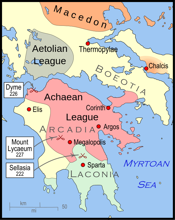
English: Mainland Greece during the time of the Cleomenean War, ca. 228 BCE |
| 日期 | |
| 來源 | 自己的作品 |
| 作者 | MapMaster |
| 其他版本 |
[]
|


-pt.svg)


References
[編輯]
The map itself was built using File:Greece map blank.svg, adding the now-drained Lake Copais. Towns were placed using geographic coordinates.
The borders of the various political entities were taken from several sources:
- Chamoux, François (2002) Hellenistic civilization, Wiley-Blackwell, ISBN 9780631222422, p. 206, for the Achaean League. I did not use this for the Aetolian League, since this map shows the later and larger borders of the Aetolian League, after the Cleomenean War.
- Gabbert, Janice J. (1997) Antigonus II Gonatas: a political biography, Routledge, ISBN 9780415018999 , p. 33, for the area under the control of Macedon.
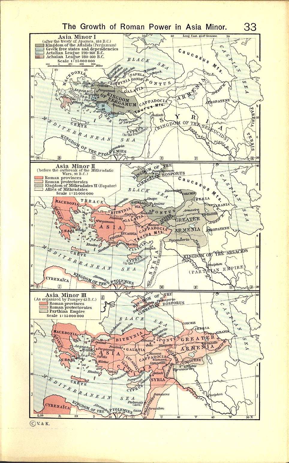
- Shepherd, William (1911) "The Growth of Roman Power in Asia Minor", Historical Atlas, Henry Holt and Company. p. 33, was used as the primary reference for the Aetolian League.
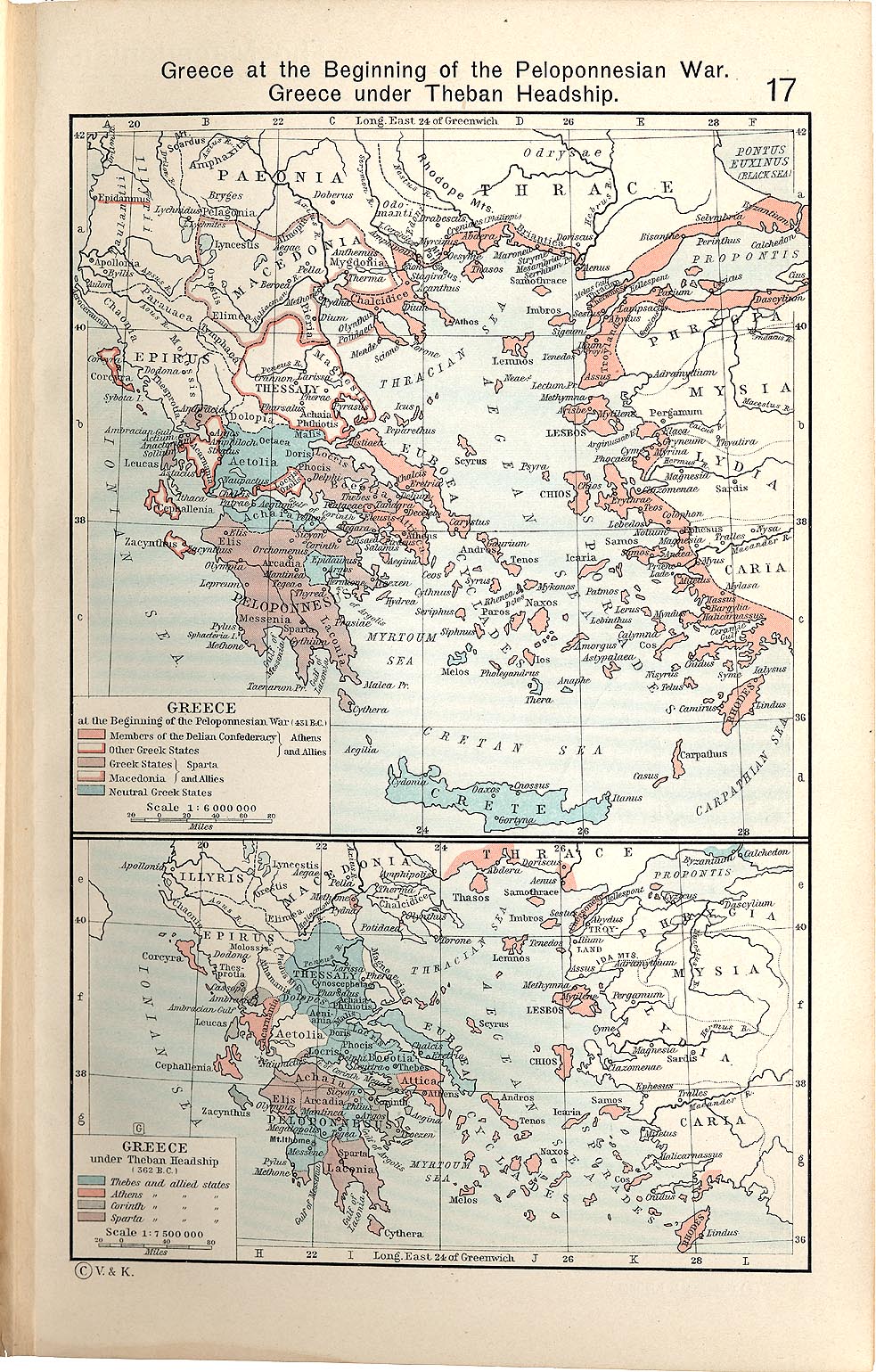
- Shepherd, William (1911) "Greece under Theban Headship", Historical Atlas, Henry Holt and Company. p. 17, was used as the primary reference for the Spartan borders. When there was a conflict with the Chamoux map, I used the Chamoux map.
Any additional information on borders and areas under control would be very welcome.
Similar maps
[編輯]

授權條款
[編輯]
我,本作品的著作權持有者,決定用以下授權條款發佈本作品:
此檔案採用共享創意 姓名標示-相同方式分享 3.0 未在地化版本授權條款。
- 您可以自由:
- 分享 – 複製、發佈和傳播本作品
- 重新修改 – 創作演繹作品
- 惟需遵照下列條件:
- 姓名標示 – 您必須指名出正確的製作者,和提供授權條款的連結,以及表示是否有對內容上做出變更。您可以用任何合理的方式來行動,但不得以任何方式表明授權條款是對您許可或是由您所使用。
- 相同方式分享 – 如果您利用本素材進行再混合、轉換或創作,您必須基於如同原先的相同或兼容的條款,來分布您的貢獻成品。
檔案歷史
點選日期/時間以檢視該時間的檔案版本。
| 日期/時間 | 縮圖 | 尺寸 | 用戶 | 備註 | |
|---|---|---|---|---|---|
| 目前 | 2010年1月12日 (二) 04:57 | | 431 × 542(982 KB) | MapMaster(對話 | 貢獻) | {{Information |Description={{en|1=A map of Greece during the Cleomenean War}} |Source={{own}} |Author=MapMaster |Date=11 January 2010 |Permission= |other_versions= }} Category:Maps of the history of Greece |
無法覆蓋此檔案。
檔案用途
下列13個頁面有用到此檔案:
- File:Cleomenean War Overview.svg (檔案重新導向)
- File:Cleomenes War detail 1.svg
- File:Map Cleomenean War-en.svg
- File:Map Cleomenean War-es.svg
- File:Map Cleomenean War-fr.svg
- File:Map Cleomenean War-he.svg
- File:Map Cleomenean War-hu.svg
- File:Map Cleomenean War-it.svg
- File:Map Cleomenean War-pt.svg
- File:Map Cleomenean War-zh.svg
- File:Map Cleomenean War (geo)-pt.svg
- Template:Other versions/Map Cleomenean War
- Category:Cleomenean War
全域檔案使用狀況
以下其他 wiki 使用了這個檔案:
- ar.wikipedia.org 的使用狀況
- bg.wikipedia.org 的使用狀況
- ca.wikipedia.org 的使用狀況
- el.wikipedia.org 的使用狀況
- en.wikipedia.org 的使用狀況
- et.wikipedia.org 的使用狀況
- he.wikipedia.org 的使用狀況
- it.wikipedia.org 的使用狀況
- ja.wikipedia.org 的使用狀況
- ko.wikipedia.org 的使用狀況
- nl.wikipedia.org 的使用狀況
- sh.wikipedia.org 的使用狀況
- tr.wikipedia.org 的使用狀況
- uk.wikipedia.org 的使用狀況
- vi.wikipedia.org 的使用狀況
- www.wikidata.org 的使用狀況
- zh.wikipedia.org 的使用狀況