File:Map Crusader states 1190-en.svg
ナビゲーションに移動
検索に移動

この SVG ファイルのこの PNG プレビューのサイズ: 441 × 600 ピクセル. その他の解像度: 176 × 240 ピクセル | 353 × 480 ピクセル | 565 × 768 ピクセル | 753 × 1,024 ピクセル | 1,506 × 2,048 ピクセル | 978 × 1,330 ピクセル。
元のファイル (SVG ファイル、978 × 1,330 ピクセル、ファイルサイズ: 470キロバイト)
キャプション
キャプション
このファイルの内容を1行で記述してください
概要
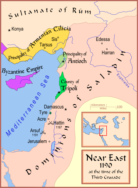
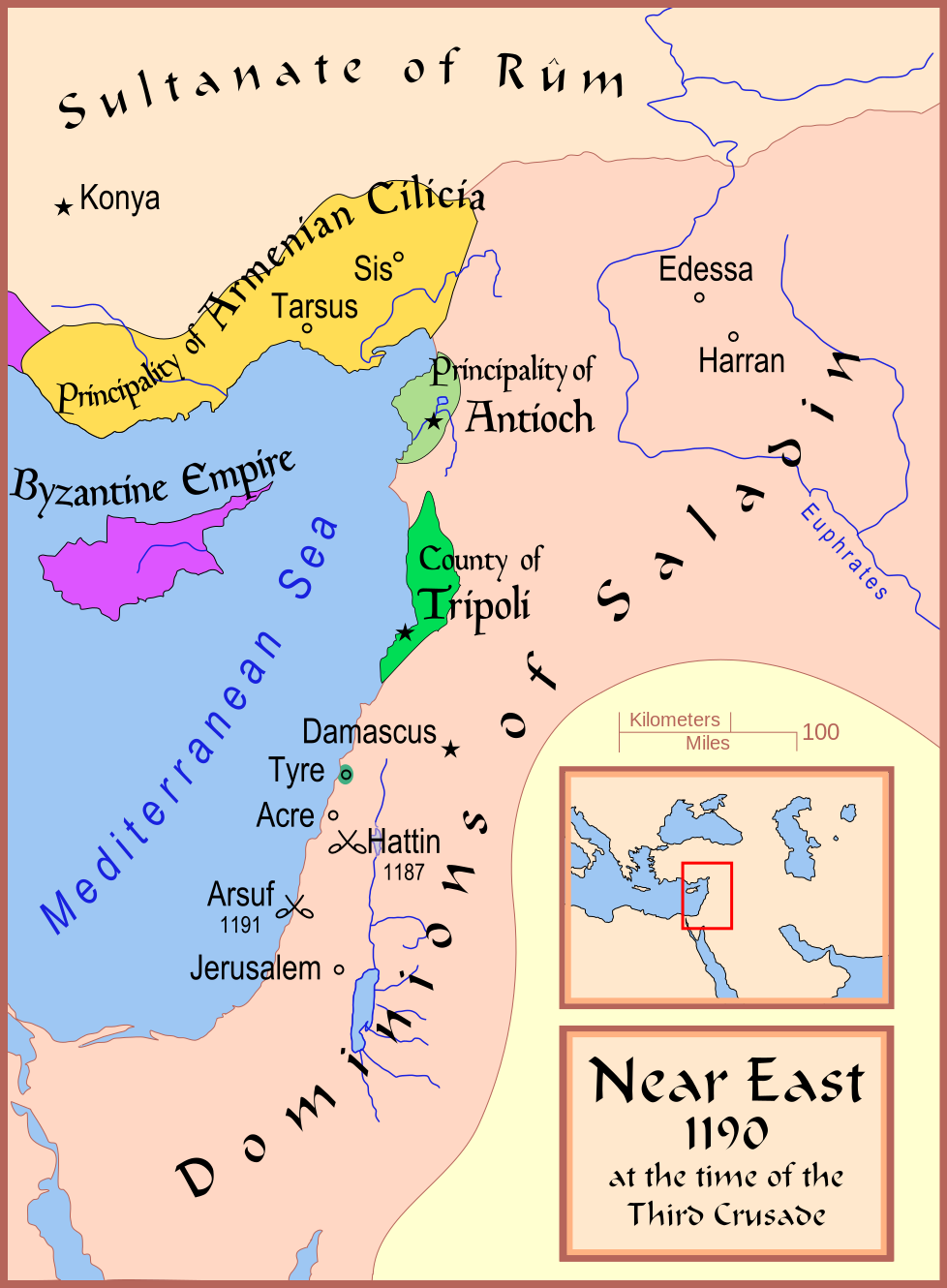
[編集]| 解説 | A map showing the Near East (the Levant) in 1190. |
| 日付 | |
| 原典 | 投稿者自身による著作物 |
| 作者 | MapMaster |
| その他のバージョン |
[]
See also[編集] |


References
[編集]
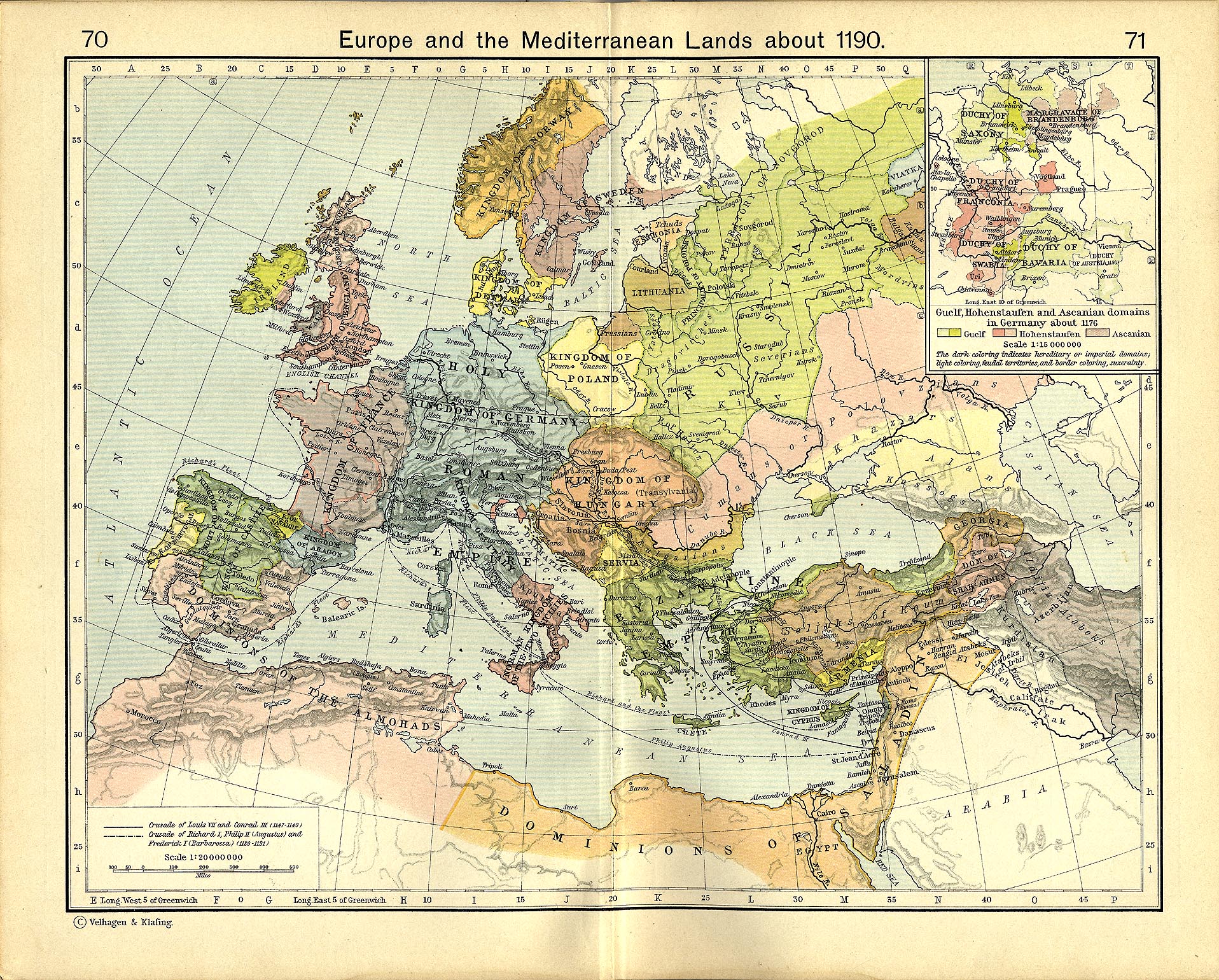
- Shepherd, William R. (1911) "Europe and the Mediterranean Lands about 1190"
ライセンス
[編集]
この作品の著作権者である私は、この作品を以下のライセンスで提供します。

|
この文書は、フリーソフトウェア財団発行のGNUフリー文書利用許諾書 (GNU Free Documentation License) 1.2またはそれ以降のバージョンの規約に基づき、複製や再配布、改変が許可されます。不可変更部分、表紙、背表紙はありません。このライセンスの複製は、GNUフリー文書利用許諾書という章に含まれています。 |
This file is licensed under the Creative Commons Attribution-Share Alike Attribution-Share Alike 4.0 International, 3.0 Unported, 2.5 Generic, 2.0 Generic and 1.0 Generic license.
- あなたは以下の条件に従う場合に限り、自由に
- 共有 – 本作品を複製、頒布、展示、実演できます。
- 再構成 – 二次的著作物を作成できます。
- あなたの従うべき条件は以下の通りです。
- 表示 – あなたは適切なクレジットを表示し、ライセンスへのリンクを提供し、変更があったらその旨を示さなければなりません。これらは合理的であればどのような方法で行っても構いませんが、許諾者があなたやあなたの利用行為を支持していると示唆するような方法は除きます。
- 継承 – もしあなたがこの作品をリミックスしたり、改変したり、加工した場合には、あなたはあなたの貢献部分を元の作品とこれと同一または互換性があるライセンスの下に頒布しなければなりません。
あなたは上記のライセンスから、どれか一つ以上を選択できます。
ファイルの履歴
過去の版のファイルを表示するには、その版の日時をクリックしてください。
| 日付と時刻 | サムネイル | 寸法 | 利用者 | コメント | |
|---|---|---|---|---|---|
| 現在の版 | 2008年2月13日 (水) 17:35 | | 978 × 1,330 (470キロバイト) | MapMaster (トーク | 投稿記録) | Slight changes |
| 2008年2月13日 (水) 17:28 |  | 978 × 1,330 (464キロバイト) | MapMaster (トーク | 投稿記録) | {{Information |Description=A map showing the Near East (the Levant) in 1190. |Source=self-made |Date=12 Feb 2008 |Author= MapMaster |Permission= |other_versions=see below }} ==Other versions== *[[:Image:Die Levante 1135 |
このファイルは上書きできません。
ファイルの使用状況
以下の 25 ページがこのファイルを使用しています:
- File:Ciutats dels estats llatins2.png
- File:Crusader States 1190.svg (リダイレクト)
- File:Crusader States 1190 cs.svg
- File:Map Crusader states 1190-ar.svg
- File:Map Crusader states 1190-arz.png
- File:Map Crusader states 1190-cs.svg
- File:Map Crusader states 1190-de.svg
- File:Map Crusader states 1190-en.svg
- File:Map Crusader states 1190-es.svg
- File:Map Crusader states 1190-fa.svg
- File:Map Crusader states 1190-fr.svg
- File:Map Crusader states 1190-fr2.svg
- File:Map Crusader states 1190-he.svg
- File:Map Crusader states 1190-it.svg
- File:Map Crusader states 1190-ka.png
- File:Map Crusader states 1190-pt.svg
- File:Map Crusader states 1190-ru.svg
- Template:Other versions/Map Crusader states 1190
グローバルなファイル使用状況
以下に挙げる他のウィキがこの画像を使っています:
- arz.wikipedia.org での使用状況
- azb.wikipedia.org での使用状況
- az.wikipedia.org での使用状況
- be.wikipedia.org での使用状況
- bg.wikipedia.org での使用状況
- br.wikipedia.org での使用状況
- ckb.wikipedia.org での使用状況
- da.wikipedia.org での使用状況
- de.wikipedia.org での使用状況
- el.wikipedia.org での使用状況
- en.wikipedia.org での使用状況
- Kingdom of Jerusalem
- Richard I of England
- 1190
- Third Crusade
- Guy of Lusignan
- Battle of Arsuf
- Conrad of Montferrat
- Crusader states
- Krak des Chevaliers
- Siege of Acre (1189–1191)
- Bohemond III of Antioch
- Bohemond IV of Antioch
- Talk:Battle of Hattin
- Crusades
- Timeline of the Kingdom of Jerusalem
- Timeline of the Principality of Antioch
- Fall of Outremer
- User:Dr. Grampinator/sandbox/Crusade Chronology, Second Part
- User:Falcaorib/Medieval Empires (1100-1200 AD)
- et.wikipedia.org での使用状況
- fi.wikipedia.org での使用状況
- he.wikipedia.org での使用状況
- hr.wikipedia.org での使用状況
- hu.wikipedia.org での使用状況
このファイルのグローバル使用状況を表示する。
カテゴリ:
- Maps showing 12th-century history
- Maps of the history of the Middle East
- Maps of the crusades
- Maps of the Kingdom of Jerusalem
- Maps of the County of Tripoli
- Maps of the Principality of Antioch
- Maps of Cilicia
- Maps of the history of Cyprus
- Maps of the history of the Levant
- English-language SVG maps showing history