File:Map Crusader states 1190-en.svg
跳转到导航
跳转到搜索

此SVG文件的PNG预览的大小:441 × 600像素。 其他分辨率:176 × 240像素 | 353 × 480像素 | 565 × 768像素 | 753 × 1,024像素 | 1,506 × 2,048像素 | 978 × 1,330像素。
原始文件 (SVG文件,尺寸为978 × 1,330像素,文件大小:470 KB)
说明
说明
添加一行文字以描述该文件所表现的内容
摘要[编辑]
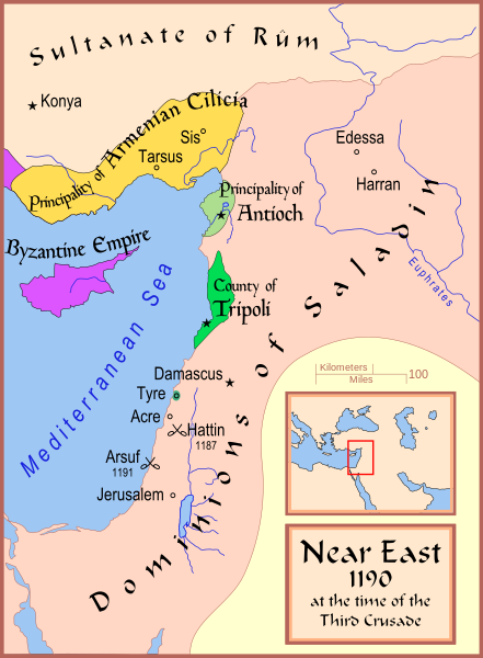
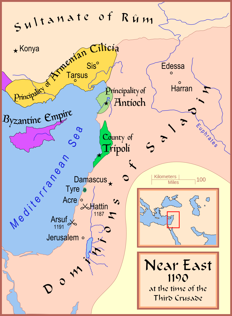
| 描述 | A map showing the Near East (the Levant) in 1190. |
| 日期 | |
| 来源 | 自己的作品 |
| 作者 | MapMaster |
| 其他版本 |
[]
See also[编辑] |


References[编辑]
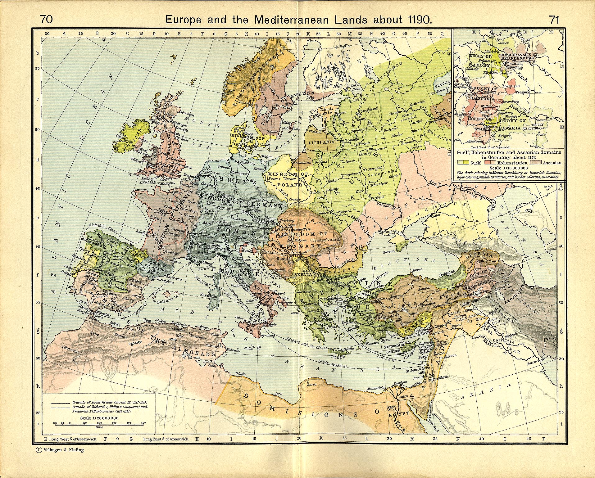
- Shepherd, William R. (1911) "Europe and the Mediterranean Lands about 1190"
许可协议[编辑]
我,本作品著作权人,特此采用以下许可协议发表本作品:

|
已授权您依据自由软件基金会发行的无固定段落及封面封底文字(Invariant Sections, Front-Cover Texts, and Back-Cover Texts)的GNU自由文件许可协议1.2版或任意后续版本的条款,复制、传播和/或修改本文件。该协议的副本请见“GNU Free Documentation License”。 |
This file is licensed under the Creative Commons Attribution-Share Alike 4.0 International, 3.0 Unported, 2.5 Generic, 2.0 Generic and 1.0 Generic license.
- 您可以自由地:
- 共享 – 复制、发行并传播本作品
- 修改 – 改编作品
- 惟须遵守下列条件:
- 署名 – 您必须对作品进行署名,提供授权条款的链接,并说明是否对原始内容进行了更改。您可以用任何合理的方式来署名,但不得以任何方式表明许可人认可您或您的使用。
- 相同方式共享 – 如果您再混合、转换或者基于本作品进行创作,您必须以与原先许可协议相同或相兼容的许可协议分发您贡献的作品。
您可以选择您需要的许可协议。
文件历史
点击某个日期/时间查看对应时刻的文件。
| 日期/时间 | 缩略图 | 大小 | 用户 | 备注 | |
|---|---|---|---|---|---|
| 当前 | 2008年2月13日 (三) 17:35 | | 978 × 1,330(470 KB) | MapMaster(留言 | 贡献) | Slight changes |
| 2008年2月13日 (三) 17:28 |  | 978 × 1,330(464 KB) | MapMaster(留言 | 贡献) | {{Information |Description=A map showing the Near East (the Levant) in 1190. |Source=self-made |Date=12 Feb 2008 |Author= MapMaster |Permission= |other_versions=see below }} ==Other versions== *[[:Image:Die Levante 1135 |
您不可以覆盖此文件。
文件用途
以下25个页面使用本文件:
- File:Ciutats dels estats llatins2.png
- File:Crusader States 1190.svg(文件重定向)
- File:Crusader States 1190 cs.svg
- File:Map Crusader states 1190-ar.svg
- File:Map Crusader states 1190-arz.png
- File:Map Crusader states 1190-cs.svg
- File:Map Crusader states 1190-de.svg
- File:Map Crusader states 1190-en.svg
- File:Map Crusader states 1190-es.svg
- File:Map Crusader states 1190-fa.svg
- File:Map Crusader states 1190-fr.svg
- File:Map Crusader states 1190-fr2.svg
- File:Map Crusader states 1190-he.svg
- File:Map Crusader states 1190-it.svg
- File:Map Crusader states 1190-ka.png
- File:Map Crusader states 1190-pt.svg
- File:Map Crusader states 1190-ru.svg
- Template:Other versions/Map Crusader states 1190
全域文件用途
以下其他wiki使用此文件:
- arz.wikipedia.org上的用途
- azb.wikipedia.org上的用途
- az.wikipedia.org上的用途
- be.wikipedia.org上的用途
- bg.wikipedia.org上的用途
- br.wikipedia.org上的用途
- ckb.wikipedia.org上的用途
- da.wikipedia.org上的用途
- de.wikipedia.org上的用途
- el.wikipedia.org上的用途
- en.wikipedia.org上的用途
- Kingdom of Jerusalem
- Richard I of England
- 1190
- Third Crusade
- Guy of Lusignan
- Battle of Arsuf
- Conrad of Montferrat
- Crusader states
- Krak des Chevaliers
- Siege of Acre (1189–1191)
- Bohemond III of Antioch
- Bohemond IV of Antioch
- Talk:Battle of Hattin
- Crusades
- Timeline of the Kingdom of Jerusalem
- Timeline of the Principality of Antioch
- User:Falcaorib
- Fall of Outremer
- et.wikipedia.org上的用途
- fi.wikipedia.org上的用途
- he.wikipedia.org上的用途
- hr.wikipedia.org上的用途
- hu.wikipedia.org上的用途
- hy.wikipedia.org上的用途
查看本文件的更多全域用途。
分类:
- Maps showing 12th-century history
- Maps of the history of the Middle East
- Maps of the crusades
- Maps of the Kingdom of Jerusalem
- Maps of the County of Tripoli
- Maps of the Principality of Antioch
- Maps of Cilicia
- Maps of the history of Cyprus
- Maps of the history of the Levant
- English-language SVG maps showing history