File:Map Europe alliances 1914-de.svg
跳至導覽
跳至搜尋

此 SVG 檔案的 PNG 預覽的大小:800 × 475 像素。 其他解析度:320 × 190 像素 | 640 × 380 像素 | 1,024 × 608 像素 | 1,280 × 761 像素 | 2,560 × 1,521 像素 | 998 × 593 像素。
原始檔案 (SVG 檔案,表面大小:998 × 593 像素,檔案大小:124 KB)
說明
說明
添加單行說明來描述出檔案所代表的內容
| 描述 |
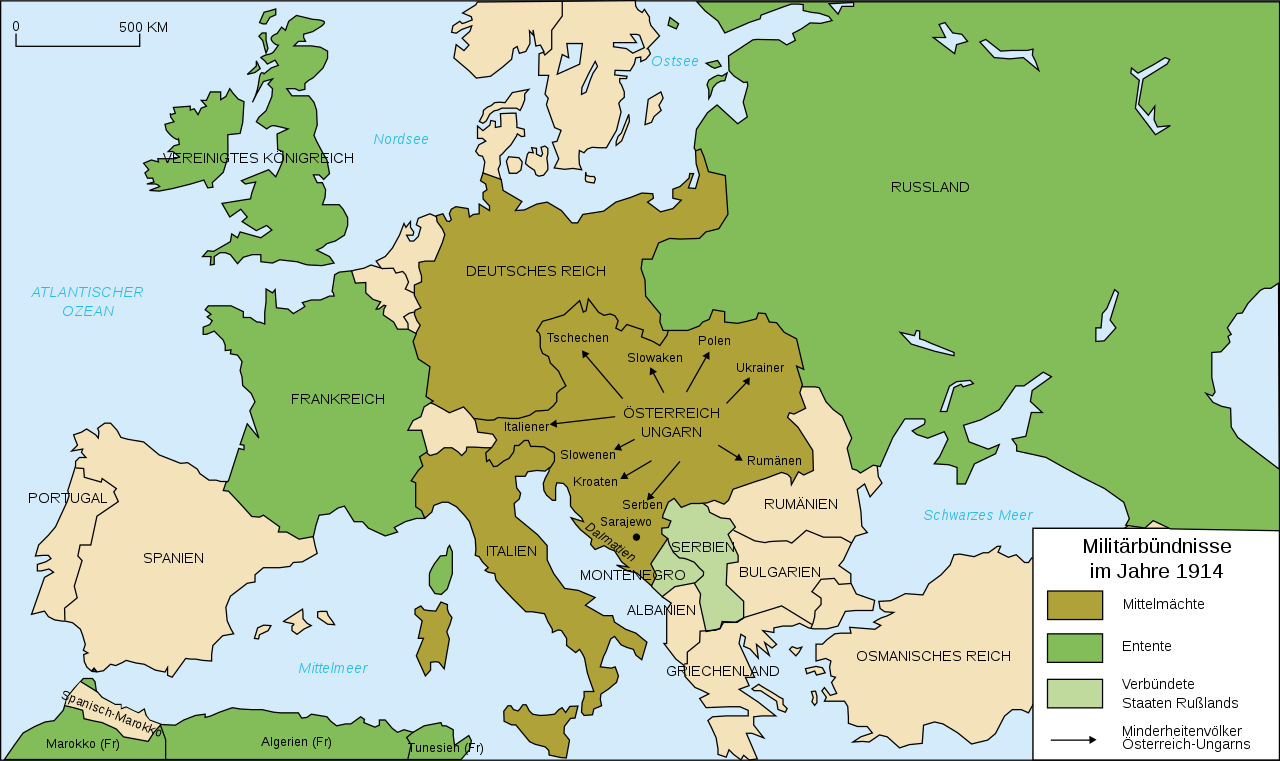
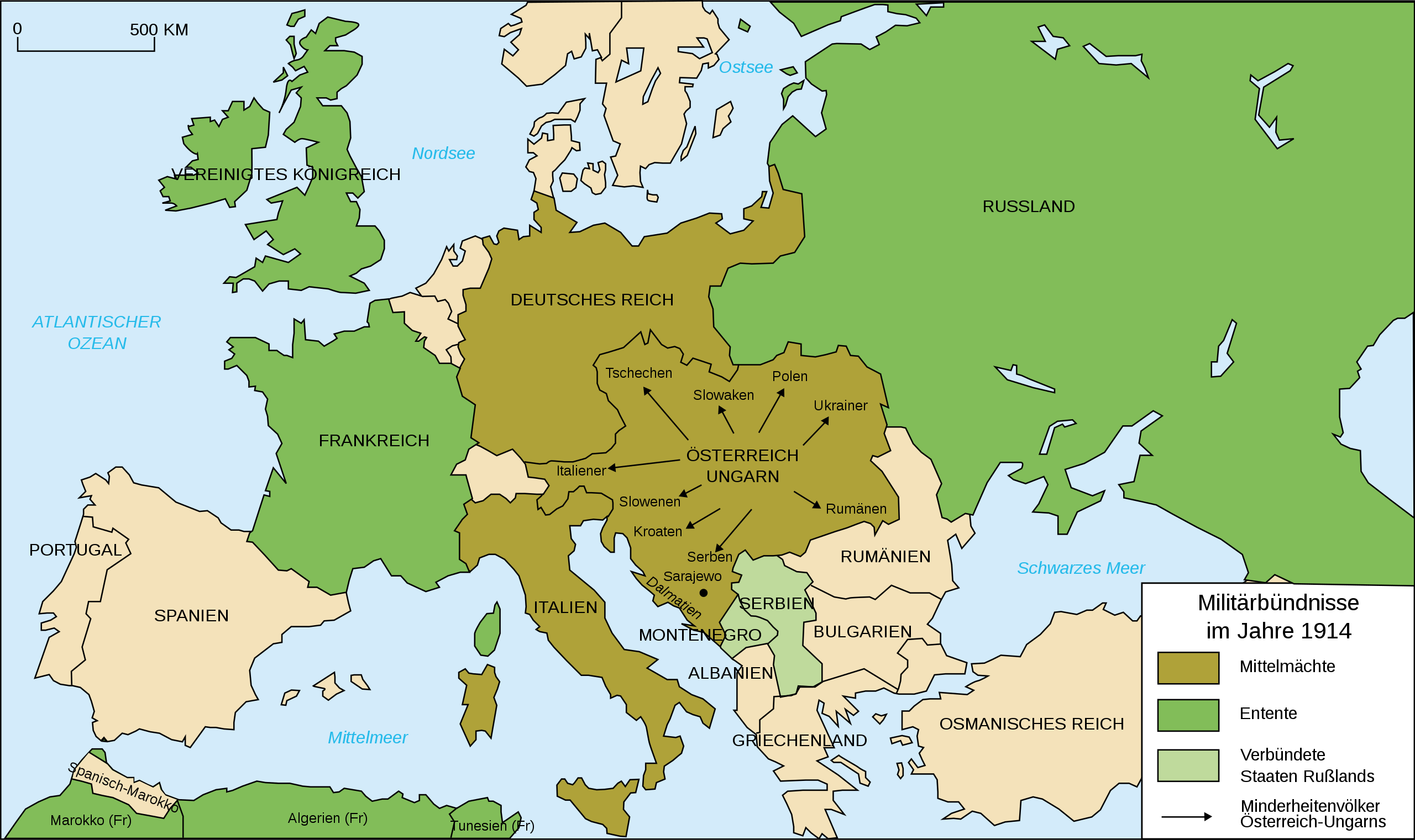
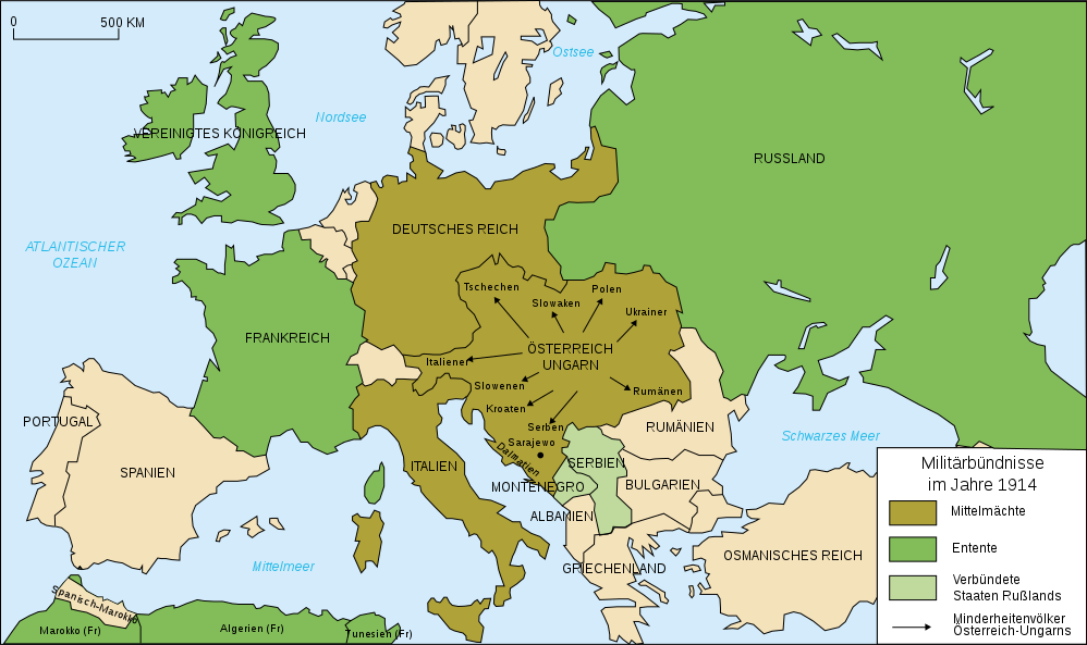
Deutsch: Karte von Militärbündnisse in Europa in 1914, (deutsch)
English: Map of military alliances of Europe in 1914. (German)
Français : Carte des alliances militaires en Europe en 1914 (Allemagne).
Русский: Схема военных альянсов в Европе в 1914 г. (нем.) |
| 日期 | (UTC) |
| 來源 | |
| 作者 |
|
| 其他版本 |
Derivative works of this file: Map Europe alliances 1914-sv.svg
[]
|
.gif)


| 這是一張修飾過的圖片,即本圖片是用軟體修改過後的版本,修改的方式或內容有:Into German, auf deutsch。原版圖片來源:Map Europe alliances 1914-fr.svg。修改者:Danbornekde。
|
我,本作品的著作權持有者,決定用以下授權條款發佈本作品:
原始上傳日誌
[編輯]
This image is a derivative work of the following images:
- Image:Map_Europe_alliances_1914-fr.svg licensed with Cc-by-sa-2.5,2.0,1.0
- 2007-02-26T23:36:35Z Bibi Saint-Pol 998x593 (100171 Bytes) {{Information |Description= {{fr|Carte des alliances militaires en Europe en 1914.}} |Source=Création personnelle (version renommée de [[:Image:Les rivalités en Europe en 1914.svg]]) |Date=2006-10-31 |Author=[[User:Histori
Uploaded with derivativeFX
檔案歷史
點選日期/時間以檢視該時間的檔案版本。
| 日期/時間 | 縮圖 | 尺寸 | 用戶 | 備註 | |
|---|---|---|---|---|---|
| 目前 | 2020年2月1日 (六) 20:34 | | 998 × 593(124 KB) | Radek Linner(對話 | 貢獻) | File uploaded using svgtranslate tool (https://tools.wmflabs.org/svgtranslate/). Added translation for cs. |
| 2015年11月30日 (一) 21:15 |  | 998 × 593(98 KB) | Turnless(對話 | 貢獻) | Russian islands | |
| 2010年7月19日 (一) 11:14 |  | 998 × 593(98 KB) | KaterBegemot(對話 | 貢獻) | Minor graphical corrections. "Militärbündnisse in 1914" was a incorrect translation. | |
| 2009年1月25日 (日) 22:25 |  | 998 × 593(100 KB) | Tinloaf(對話 | 貢獻) | Fixing some spelling mistakes. | |
| 2008年10月4日 (六) 02:00 |  | 998 × 593(98 KB) | Danbornekde~commonswiki(對話 | 貢獻) | {{Information |Description={{fr|Carte des alliances militaires en Europe en 1914.}} Karte von Militärbündnisse in Europa in 1914, deutsch |Source=*Image:Map_Europe_alliances_1914-fr.svg |Date=2008-10-04 01:57 (UTC) |Author=*derivative work: ~~~ * |
無法覆蓋此檔案。
檔案用途
下列38個頁面有用到此檔案:
- User:Magog the Ogre/Maps of conflicts/2015 November
- User:Magog the Ogre/Maps of conflicts/2020 February
- File:1914 ஐரோப்பியக் கூட்டணிகள்.svg
- File:1914년 유럽의 군사동맹지도.PNG
- File:Alliances militaires en Europe 1914-1918-hy.png
- File:Kartenn aliañsoù Europa 1914-br.svg
- File:Map Europe alliances 1914-ar.svg
- File:Map Europe alliances 1914-az.svg
- File:Map Europe alliances 1914-bg.svg
- File:Map Europe alliances 1914-bn.svg
- File:Map Europe alliances 1914-ce.svg
- File:Map Europe alliances 1914-cs.svg
- File:Map Europe alliances 1914-de.svg
- File:Map Europe alliances 1914-el.svg
- File:Map Europe alliances 1914-en.svg
- File:Map Europe alliances 1914-eo.svg
- File:Map Europe alliances 1914-es.svg
- File:Map Europe alliances 1914-fr.svg
- File:Map Europe alliances 1914-gl.svg
- File:Map Europe alliances 1914-he.svg
- File:Map Europe alliances 1914-hr.svg
- File:Map Europe alliances 1914-hu.svg
- File:Map Europe alliances 1914-hy.jpg
- File:Map Europe alliances 1914-it.svg
- File:Map Europe alliances 1914-ko.svg
- File:Map Europe alliances 1914-la.svg
- File:Map Europe alliances 1914-lt.svg
- File:Map Europe alliances 1914-mk.svg
- File:Map Europe alliances 1914-nl.svg
- File:Map Europe alliances 1914-no.svg
- File:Map Europe alliances 1914-ro.svg
- File:Map Europe alliances 1914-sr.svg
- File:Map Europe alliances 1914-sv.svg
- File:Map Europe alliances 1914-ta.png
- File:Map Europe alliances 1914-uk.svg
- File:PotenciasEnLiza1914-pt.svg
- File:PotenciasEnLiza1914.svg
- Template:Other versions/Map Europe alliances 1914
全域檔案使用狀況
以下其他 wiki 使用了這個檔案:
- de.wikipedia.org 的使用狀況
- nds.wikipedia.org 的使用狀況
- rm.wikipedia.org 的使用狀況
- zh.wikipedia.org 的使用狀況