File:Map Iran railways en.svg
Ir a la navegación
Ir a la búsqueda

Tamaño de esta previsualización PNG del archivo SVG: 695 × 600 píxeles. Otras resoluciones: 278 × 240 píxeles | 556 × 480 píxeles | 890 × 768 píxeles | 1187 × 1024 píxeles | 2374 × 2048 píxeles | 2318 × 2000 píxeles.
Archivo original (archivo SVG, nominalmente 2318 × 2000 píxeles, tamaño de archivo: 7,15 MB)
Leyendas
Leyendas
Añade una explicación corta acerca de lo que representa este archivo
Resumen
[editar]| Descripción |
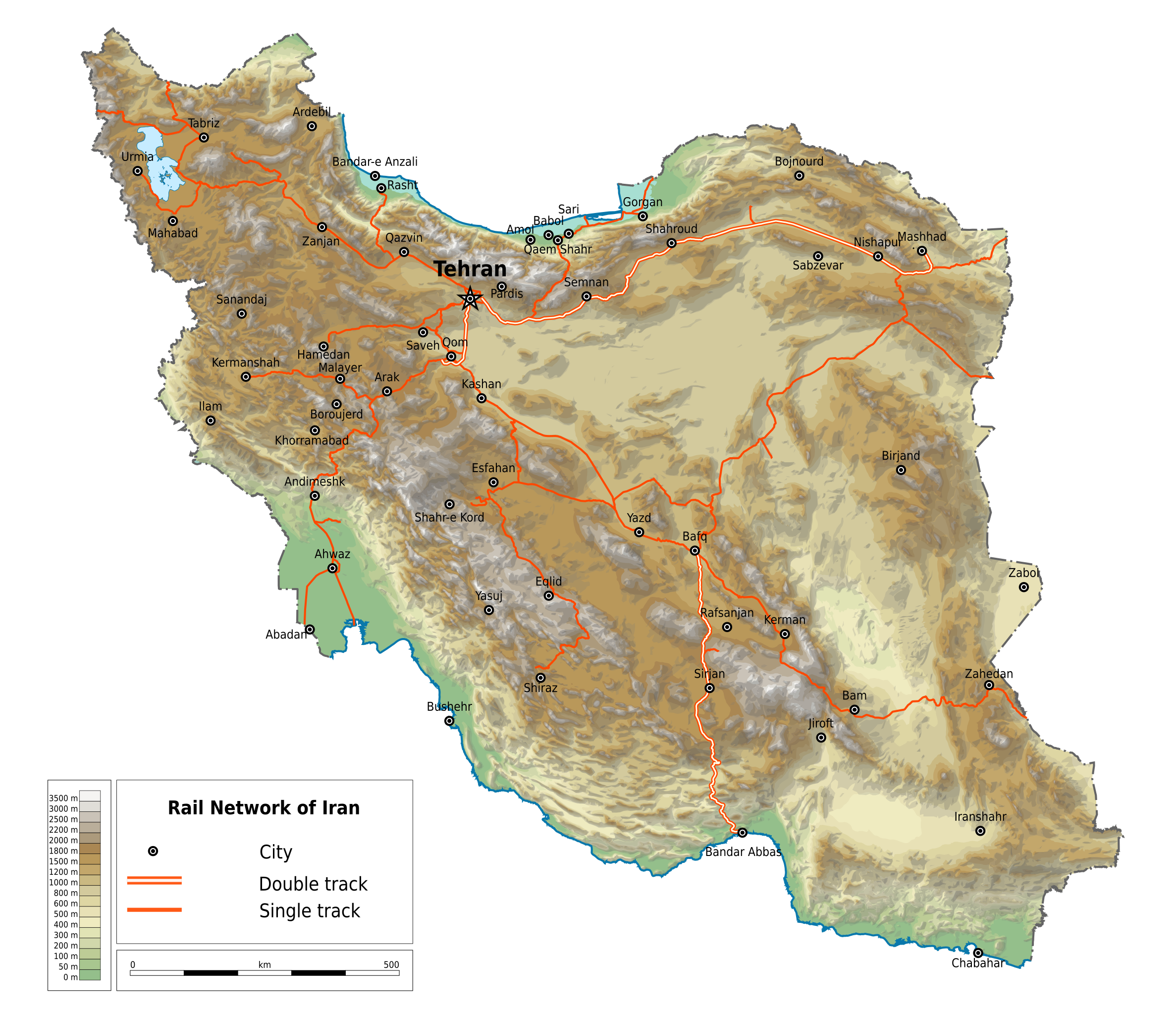
English: Map of railways in Iran (in English). Limits of the map:
|
| Fecha | |
| Fuente | File:Map Iran railways fa.svg |
| Autor | Ikonact |
| Permiso (Reutilización de este archivo) |
Any use of this map is subject of the license(s) stated below with the condition that you credit (Wikimedia Commons user: Ikonact) as the author . A message with a reply address would also be greatly appreciated. |
| Otras versiones |
|

Licencia
[editar]
| This work contains information from OpenStreetMap, which is made available under the Open Database License (ODbL).
The ODbL does not require any particular license for maps produced from ODbL data. Prior to 1 August 2020, map tiles produced by the OpenStreetMap Foundation were licensed under the CC-BY-SA-2.0 license. Maps produced by other people may be subject to other licences. |
Yo, el titular de los derechos de autor de esta obra, la publico en los términos de la siguiente licencia:
Este archivo está disponible bajo la licencia Creative Commons Attribution-Share Alike 4.0 International.
- Eres libre:
- de compartir – de copiar, distribuir y transmitir el trabajo
- de remezclar – de adaptar el trabajo
- Bajo las siguientes condiciones:
- atribución – Debes otorgar el crédito correspondiente, proporcionar un enlace a la licencia e indicar si realizaste algún cambio. Puedes hacerlo de cualquier manera razonable pero no de manera que sugiera que el licenciante te respalda a ti o al uso que hagas del trabajo.
- compartir igual – En caso de mezclar, transformar o modificar este trabajo, deberás distribuir el trabajo resultante bajo la misma licencia o una compatible como el original.
Historial del archivo
Haz clic sobre una fecha y hora para ver el archivo tal como apareció en ese momento.
| Fecha y hora | Miniatura | Dimensiones | Usuario | Comentario | |
|---|---|---|---|---|---|
| actual | 22:42 28 mar 2020 | | 2318 × 2000 (7,15 MB) | Ikonact (discusión | contribs.) | == {{int:filedesc}} == {{Information |description={{en|1=Map of railways in {{W|Iran}} (in English). Limits of the map:}} *N: 40.229° N *S: 24.327° N *W: 42.517° E *E: 64.314° E Equidistant Cylindrical projection; WGS 84 datum |date=2019-03-28 |source=File:Map Iran railways fa.svg |author={{U|Ikonact}} |permission=Any use of this map is subject of the license(s) stated below with the condition that you credit (Wikimedia Commons user: Ikonact) as the author . A [http://c... |
No puedes sobrescribir este archivo.
Usos del archivo
Las siguientes páginas usan este archivo:
Uso global del archivo
Las wikis siguientes utilizan este archivo:
- Uso en de.wikipedia.org
- Uso en en.wikipedia.org
- Uso en fr.wikipedia.org
- Uso en hu.wikipedia.org
- Uso en it.wikipedia.org
- Uso en it.wikivoyage.org
- Uso en ja.wikipedia.org
- Uso en nn.wikipedia.org
- Uso en no.wikipedia.org
- Uso en ru.wikipedia.org
- Uso en tr.wikipedia.org
- Uso en zh.wikipedia.org