File:Map Italophone World.png
Ir a la navegación
Ir a la búsqueda

Tamaño de esta previsualización: 800 × 338 píxeles. Otras resoluciones: 320 × 135 píxeles | 640 × 270 píxeles | 1480 × 625 píxeles.
Archivo original (1480 × 625 píxeles; tamaño de archivo: 47 kB; tipo MIME: image/png)
Leyendas
Leyendas
Añade una explicación corta acerca de lo que representa este archivo
Resumen[editar]

|
File:Linguistic map of the Italian language.svg es una versión vectorial de este archivo. Debería usarse esa versión en lugar de este archivo PNG, cuando sea mejor.
File:Map Italophone World.png → File:Linguistic map of the Italian language.svg
Para más información, lee Ayuda:SVG. |
 |
| Descripción |
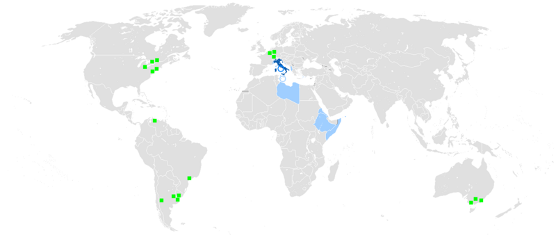
Deutsch: Legende:
English: Legend:
Español: Leyenda:
Français : Carte du monde où on parle l'italien.
Català: Llegenda:
Italiano: Legenda:
Português: Legenda:
Română: Legendă:
Türkçe: İçerik:
中文:图例:
|
| Fuente | Map made from Image:BlankMap-World.png |
| Autor | Uploaded by User:Ilario. |
Licencia[editar]
| Este trabajo ha sido liberado al dominio público por su autor, Ilario. Esto aplica para todo el mundo. En algunos países esto puede no ser legalmente factible; si ello ocurriese: |
Historial del archivo
Haz clic sobre una fecha y hora para ver el archivo tal como apareció en ese momento.
| Fecha y hora | Miniatura | Dimensiones | Usuario | Comentario | |
|---|---|---|---|---|---|
| actual | 08:42 1 ago 2021 | | 1480 × 625 (47 kB) | MMMM fan (discusión | contribs.) | Reverted to version as of 04:25, 12 February 2013 (UTC) Removing outdated or inaccurate Italophone minorities |
| 19:04 11 may 2021 |  | 1365 × 577 (90 kB) | MMMM fan (discusión | contribs.) | Reverted to version as of 10:24, 7 March 2018 (UTC) | |
| 17:19 20 abr 2018 |  | 1074 × 562 (84 kB) | DavideVeloria88 (discusión | contribs.) | {{Vector version available |1=Italianomundo.svg }} {{Information |Description= {{de|Legende: *Dunkelblau: Muttersprache *Blau: Verwaltungssprache *Hellblau: Zweit- bzw. nichtoffizielle Sprache *Grüne Quadrate: Italienischsprachige Minderheit}} {{en|Legend: *Dark blue: Native language *Blue: Administrative language *Light blue: Secondary language or non-official. *green square: Italophone minorities}} {{es|Leyenda: *azul oscuro: Lengua materna *azul: lengua Administrativa *azul claro: Segund... | |
| 19:49 16 abr 2018 |  | 1074 × 562 (101 kB) | DavideVeloria88 (discusión | contribs.) | {{Vector version available |1=Italianomundo.svg }} {{Information |Description= {{de|Legende: *Dunkelblau: Muttersprache *Blau: Verwaltungssprache *Hellblau: Zweit- bzw. nichtoffizielle Sprache *Grüne Quadrate: Italienischsprachige Minderheit}} {{en|Legend: *Dark blue: Native language *Blue: Administrative language *Light blue: Secondary language or non-official. *green square: Italophone minorities}} {{es|Leyenda: *azul oscuro: Lengua materna *azul: lengua Administrativa *azul claro: Segund... | |
| 10:24 7 mar 2018 |  | 1365 × 577 (90 kB) | Maphobbyist (discusión | contribs.) | Update | |
| 20:40 8 feb 2018 |  | 1365 × 577 (109 kB) | Koreanovsky (discusión | contribs.) | Croatia & Slovenia - Fix: Italian is an official recognised minority language. | |
| 00:04 19 sep 2016 |  | 1365 × 577 (90 kB) | Alatab (discusión | contribs.) | A new Central America update | |
| 16:13 18 sep 2016 |  | 1480 × 625 (44 kB) | Alatab (discusión | contribs.) | SORRY THIS IS THE CORRECT ONE. I added a green square in southern Costa Rica because there is one of the most important italian minorities in Central America and the Caribbean, the San Vito community and near towns of Coto Brus canton, there are a... | |
| 16:11 18 sep 2016 |  | 1480 × 625 (44 kB) | Alatab (discusión | contribs.) | I added a green square in southern Costa Rica because there is one of the most important italian minorities in Central America and the Caribbean, the San Vito community and near towns of Coto Brus canton, there are a huge italian community. | |
| 19:55 7 ago 2015 |  | 1480 × 625 (47 kB) | AcidSnow (discusión | contribs.) | Actually, its the former official language. |
No puedes sobrescribir este archivo.
Usos del archivo
Las siguientes páginas usan este archivo:
- User:Chumwa/OgreBot/Travel and communication maps/2016 September 11-20
- User:Chumwa/OgreBot/Travel and communication maps/2018 April 11-20
- User:Chumwa/OgreBot/Travel and communication maps/2018 February 1-9
- User:Chumwa/OgreBot/Travel and communication maps/2018 March 1-10
- User:Chumwa/OgreBot/Travel and communication maps/2021 August 1-10
- User:J budissin/Uploads/BiH/2018 April 11-20
- User:J budissin/Uploads/BiH/2018 February 1-9
- User:J budissin/Uploads/BiH/2018 March 1-10
- User:Minorax/SVG available/2021 August 1-6
- File:Geographic distribution of the Italian language in the world.png (archivo de redirección)
- File:Map-Romance Language World.png
Uso global del archivo
Las wikis siguientes utilizan este archivo:
- Uso en es.wikipedia.org
- Uso en kab.wikipedia.org