File:Map Norrköping 1913.jpg
Jump to navigation
Jump to search
Size of this preview: 800 × 512 pixels. Other resolutions: 320 × 205 pixels | 640 × 410 pixels | 1,024 × 655 pixels | 1,280 × 819 pixels | 3,110 × 1,990 pixels.
Original file (3,110 × 1,990 pixels, file size: 3.35 MB, MIME type: image/jpeg)
Captions
Captions
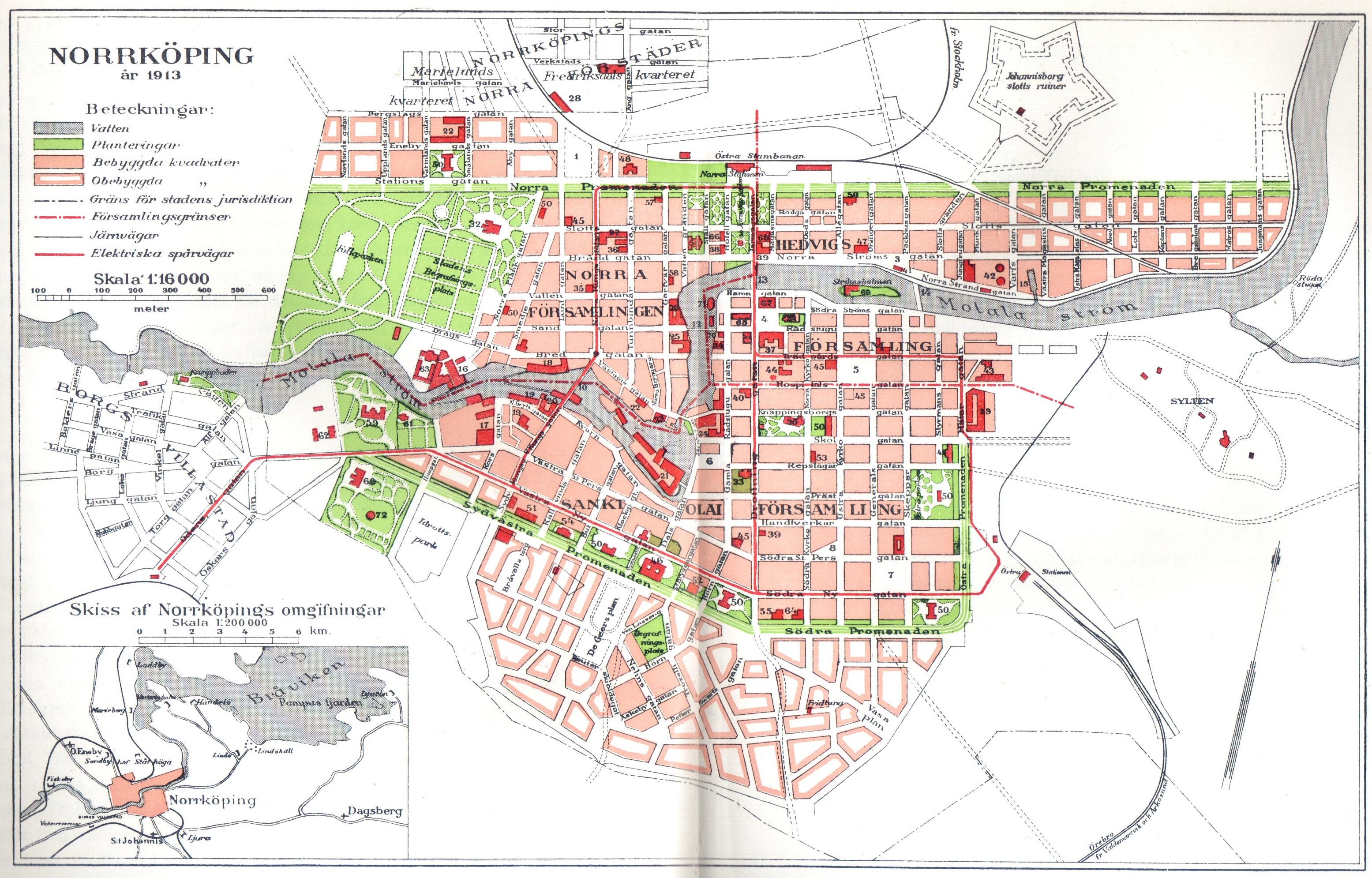
Map of Norrköping from 1913
Summary
[edit]
| Description | Map of Norrköping, Sweden |
| Date | |
| Source | Jörn Svensson m.fl. "Norrköpings historia. 10: Norrköpings ekonomiska och sociala historia 1870-1914". Stockholm 1972 |
| Author | Unknown author |
| Permission (Reusing this file) |
Public domain |
| Other versions | This map was published in the encyclopedia Nordisk Familjebok, 2nd edition, in 1913. Available online at runeberg.org |
Map description
[edit]
- Norra torget (Kungstorget)
- Karl Johans park
- Kanontorget
- Tyska torget
- Nya torget
- Gamla torget
- Stortorget
- Hötorget
- Samtalstorget (Skvallertorget)
- Bergsbron
- Järnbron
- Spången
- Oskar Fredriks bro
- Hamnbron (byggdes 1915)
- Docka
- Drags klädesfabrik
- Gryts bomullsspinneri
- Bergsbro yllefabrik
- Bergs bomullsfabrik
- Ströms yllefabrik
- Holmens bruk
- R. Wahrens klädesfabrik
- Gamlabro yllefabrik
- Svartz' tobaksfabrik
- Norrköpings Bryggeri AB
- Norrköpings Bomullsväfveri AB (Tuppen)
- Brücks yllefabrik
- AB Harvesters verkstäder
- Litografiska AB:s fabriker
- St Olai kyrka
- Hedvigs kyrka
- Matteus kyrka
- St. Johannis kyrka (Landskyrkan)
- Immanuelskyrkan (Missionsförbundet)
- Tabernaklet (Baptistkyrkan)
- Synagogan
- Rådhuset
- Stadshuset
- Postkontor
- Telegrafstation
- Tullkammaren
- Gasverk
- Elektricitetsverk
- Brandstationen
- Saluhallen
- Högre allmänna läroverket (De Geerskolan)
- Tekniska skolan (riven 1932)
- Norra flickläroverket (Pihlska skolan)
- Östra flickläroverket (Djäkneparkskolan)
- Folkskola (Matteus, Berzelius Karl Johans, De Geer, Kristina, St Olofs, Hedvigs, Gustaf Adolfs och Oskars skola)
- Militärskola (Källvindsskolan)
- Moberg-Eggerska flickskolan
- Swartziska friskolan (riven 1950)
- John Lennings vävskola
- Stadsbibliotek
- Teater
- Frimurarlogen
- IOGT:s ordenshus
- Lasarett (senare Ebersteinska skolan)
- Lenningska sjukhemmet
- Barnbördshus (rivet)
- Epidemisjukhus (rivet 1971)
- Tvångsarbetsanstalt för kvinnor
- Tinghus
- Norrköpings Enskilda bank (senare Östergötlands Enskilda Bank)
- Stora hotellet
- Göta hotell (senare Grand hotell)
- Standard hotell
- Strömsholmens servering (nedbrunnen 1939)
- Varmbadhus (rivet 1972)
- Kallbadhus (rivet cirka 1920)
- Vattentorn
This file is in the public domain because This map was published by Norrköpings stad in 1913. There are no names of the municipality clerks who produced the map on the map. Since more than 70 years have gone since the publication, this map is hence in the public domain.
|
This image was first published in the 1st (1876–1899), 2nd (1904–1926) or 3rd (1923–1937) edition of Nordisk familjebok. The copyrights for that book have expired and this image is in the public domain, because images had no named authors and the book was published more than 70 years ago.
|
This image (or other media file) is in the public domain because its copyright has expired and its author is anonymous.
This applies to the European Union and those countries with a copyright term of 70 years after the work was made available to the public and the author never disclosed their identity. Important: Always mention where the image comes from, as far as possible, and make sure the author never claimed authorship. Note: In Germany and possibly other countries, certain anonymous works published before July 1, 1995 are copyrighted until 70 years after the death of the author. See Übergangsrecht. Please use this template only if the author never claimed authorship or their authorship never became public in any other way. If the work is anonymous or pseudonymous (e.g., published only under a corporate or organization's name), use this template for images published more than 70 years ago.
For a work made available to the public in the United Kingdom, please use Template:PD-UK-unknown instead.
|
File history
Click on a date/time to view the file as it appeared at that time.
| Date/Time | Thumbnail | Dimensions | User | Comment | |
|---|---|---|---|---|---|
| current | 22:44, 28 January 2007 | | 3,110 × 1,990 (3.35 MB) | Thuresson (talk | contribs) | better quality |
| 21:12, 27 January 2007 |  | 3,104 × 1,964 (1.13 MB) | Thuresson (talk | contribs) | {{Information |Description=Map of Norrköping, Sweden |Source=Jörn Svensson m.fl. "Norrköpings historia. 10: Norrköpings ekonomiska och sociala historia 1870-1914". Stockholm 1972 |Date=1913 |Author=Unknown |Permission=Public domain |other_versions= }} |
You cannot overwrite this file.
File usage on Commons
There are no pages that use this file.
File usage on other wikis
The following other wikis use this file:
- Usage on de.wikipedia.org
- Usage on sv.wikipedia.org