File:Map administrative divisions of the First French Empire 1812-fr.svg
跳转到导航
跳转到搜索

此SVG文件的PNG预览的大小:712 × 600像素。 其他分辨率:285 × 240像素 | 570 × 480像素 | 912 × 768像素 | 1,216 × 1,024像素 | 2,432 × 2,048像素 | 2,052 × 1,728像素。
原始文件 (SVG文件,尺寸为2,052 × 1,728像素,文件大小:2.84 MB)
说明
说明
添加一行文字以描述该文件所表现的内容
摘要
[编辑]| 描述 |
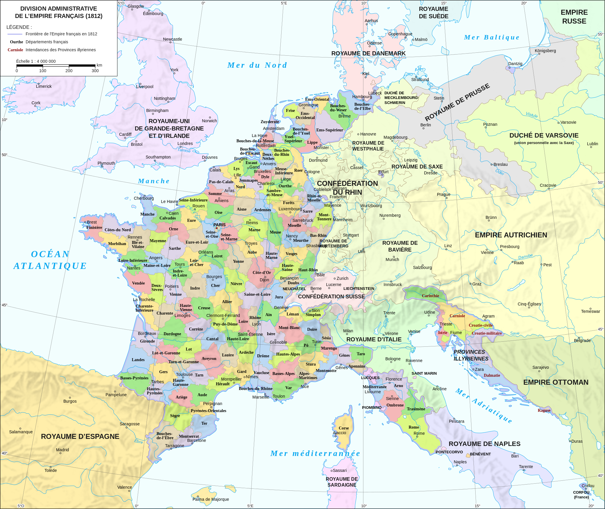
Français : Division administrative du Premier Empire Français en 1812 English: Administrative divisions of the First French Empire in 1812 - French version |
| 日期 | |
| 来源 |
|
| 作者 | Andrein |
| 其他版本 |
[]
|


|
This SVG file contains embedded text that can be translated into your language, using any capable SVG editor, text editor or the SVG Translate tool. For more information see: About translating SVG files. |
许可协议
[编辑]
我,本作品著作权人,特此采用以下许可协议发表本作品:
本文件采用知识共享署名-相同方式共享 4.0 国际许可协议授权。
- 您可以自由地:
- 共享 – 复制、发行并传播本作品
- 修改 – 改编作品
- 惟须遵守下列条件:
- 署名 – 您必须对作品进行署名,提供授权条款的链接,并说明是否对原始内容进行了更改。您可以用任何合理的方式来署名,但不得以任何方式表明许可人认可您或您的使用。
- 相同方式共享 – 如果您再混合、转换或者基于本作品进行创作,您必须以与原先许可协议相同或相兼容的许可协议分发您贡献的作品。
文件历史
点击某个日期/时间查看对应时刻的文件。
| 日期/时间 | 缩略图 | 大小 | 用户 | 备注 | |
|---|---|---|---|---|---|
| 当前 | 2015年8月26日 (三) 14:02 | | 2,052 × 1,728(2.84 MB) | Bibi Saint-Pol(留言 | 贡献) | Correction de coquilles et typographie |
| 2015年7月20日 (一) 19:41 |  | 2,052 × 1,728(2.82 MB) | ArdadN(留言 | 贡献) | spelling, some French city names | |
| 2015年7月20日 (一) 17:11 |  | 2,052 × 1,728(2.82 MB) | ArdadN(留言 | 贡献) | 1 | |
| 2015年7月20日 (一) 17:05 |  | 2,052 × 1,728(2.82 MB) | ArdadN(留言 | 贡献) | font size | |
| 2015年7月20日 (一) 16:17 |  | 2,052 × 1,728(2.82 MB) | ArdadN(留言 | 贡献) | 1 | |
| 2015年7月20日 (一) 13:56 |  | 2,052 × 1,728(2.81 MB) | ArdadN(留言 | 贡献) | Carinthie | |
| 2015年7月20日 (一) 13:51 |  | 2,052 × 1,728(2.81 MB) | ArdadN(留言 | 贡献) | better fonts | |
| 2015年7月20日 (一) 10:49 |  | 2,052 × 1,728(2.81 MB) | ArdadN(留言 | 贡献) | typhos | |
| 2015年7月19日 (日) 23:30 |  | 2,052 × 1,728(2.81 MB) | ArdadN(留言 | 贡献) | 1 | |
| 2015年7月19日 (日) 19:51 |  | 2,052 × 1,728(3.61 MB) | ArdadN(留言 | 贡献) | one more try.. |
您不可以覆盖此文件。
文件用途
以下15个页面使用本文件:
- User:Geagea/Israel/2015 August 26
- User:Geagea/Israel/2015 July 19
- User:Geagea/Israel/2015 July 20
- File:Départements français (Premier Empire).svg(文件重定向)
- File:France L-1 (1812)-fr.svg(文件重定向)
- File:Map administrative divisions of the First French Empire 1812-br.svg
- File:Map administrative divisions of the First French Empire 1812-de.svg
- File:Map administrative divisions of the First French Empire 1812-el.svg
- File:Map administrative divisions of the First French Empire 1812-en.svg
- File:Map administrative divisions of the First French Empire 1812-es.svg
- File:Map administrative divisions of the First French Empire 1812-fr.svg
- File:Map administrative divisions of the First French Empire 1812-it.svg
- File:Map administrative divisions of the First French Empire 1812-mk.svg
- File:Map administrative divisions of the First French Empire 1812-zh.svg
- Template:Other versions/Map administrative divisions of the First French Empire 1812
.svg&redirect=no)
-fr.svg&redirect=no)
全域文件用途
以下其他wiki使用此文件:
- en.wikipedia.org上的用途
- eo.wikipedia.org上的用途
- fr.wikipedia.org上的用途
- Département français
- Premier Empire
- Liste des départements français de 1811
- Pays-Bas (toponymie)
- Chronologie de la France sous le Consulat et le Premier Empire
- Histoire des départements français
- Départements français d'Espagne
- Histoire des Hautes-Alpes
- Utilisateur:Thib Phil/Bac à sable 6
- Wikipédia:Oracle/semaine 17 2012
- Discussion:Départements français d'Espagne
- Rive gauche du Rhin
- Mariage de 6 000 soldats de l'Empire
- Aspects économiques et logistiques des guerres napoléoniennes
- Discussion utilisateur:Flappiefh/Archives/2013-2016
- Discussion:Départements français d'Espagne/LSV 14420
- Wikipédia:Statistiques des anecdotes de la page d'accueil/Visibilité des anecdotes (2018)
- Wikipédia:Statistiques des anecdotes de la page d'accueil/Visibilité des anecdotes (2018)/2018 05
- Projet:Aide et accueil/Twitter/Tweets/archives/mai 2018
- Utilisateur:GhosterBot/BacASable/Aide et accueil/Twitter/Tweets/archives/mai 2018
- Wikipédia:Le saviez-vous ?/Archives/2018
- Départements français d'Allemagne
- Départements français de Suisse
- Utilisateur:DreamcoatJoey/Brouillon/Histoire de l'influence territoriale de la France
- fr.wiktionary.org上的用途
- la.wikipedia.org上的用途
- ru.wikipedia.org上的用途
- sh.wikipedia.org上的用途
- sv.wikipedia.org上的用途
- vi.wikipedia.org上的用途