File:Map depicting the Romano-Berber Kingdoms.png
Jump to navigation
Jump to search

Size of this preview: 800 × 588 pixels. Other resolutions: 320 × 235 pixels | 640 × 471 pixels | 900 × 662 pixels.
Original file (900 × 662 pixels, file size: 279 KB, MIME type: image/png)
Captions
Captions
Add a one-line explanation of what this file represents
Summary[edit]
| Description |
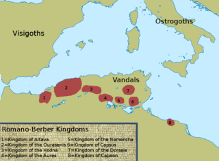
English: This is a selfmade copy based on figure 4.2 from the book "Vandals, Romans and Berbers: New Perspectives on Late Antique North Africa" by A.H. Merrills. Originally it is from Christian Curtois' "Les Vandales et l'Afrique", p. 334. It depicts the eight Christianized Romano-Berber states during the sixth century. Based on NordNordWest's "Mediterranean Sea location map (blank)" |
| Date | |
| Source | Own work |
| Author | LeGabrie |
Licensing[edit]
I, the copyright holder of this work, hereby publish it under the following license:
This file is licensed under the Creative Commons Attribution-Share Alike 4.0 International license.
- You are free:
- to share – to copy, distribute and transmit the work
- to remix – to adapt the work
- Under the following conditions:
- attribution – You must give appropriate credit, provide a link to the license, and indicate if changes were made. You may do so in any reasonable manner, but not in any way that suggests the licensor endorses you or your use.
- share alike – If you remix, transform, or build upon the material, you must distribute your contributions under the same or compatible license as the original.
File history
Click on a date/time to view the file as it appeared at that time.
| Date/Time | Thumbnail | Dimensions | User | Comment | |
|---|---|---|---|---|---|
| current | 17:21, 1 September 2018 | | 900 × 662 (279 KB) | LeGabrie (talk | contribs) | another fix |
| 17:19, 1 September 2018 |  | 900 × 662 (280 KB) | LeGabrie (talk | contribs) | lil fix | |
| 17:16, 1 September 2018 |  | 900 × 662 (280 KB) | LeGabrie (talk | contribs) | aesthetic update | |
| 21:56, 24 January 2018 |  | 900 × 662 (280 KB) | LeGabrie (talk | contribs) | Small fix | |
| 21:50, 24 January 2018 |  | 900 × 662 (280 KB) | LeGabrie (talk | contribs) | Reworked the map entirely | |
| 22:36, 23 January 2018 |  | 1,068 × 619 (156 KB) | LeGabrie (talk | contribs) | Added numbers for better orderliness. | |
| 07:06, 17 July 2015 |  | 1,068 × 619 (137 KB) | LeGabrie (talk | contribs) | User created page with UploadWizard |
You cannot overwrite this file.
File usage on Commons
There are no pages that use this file.
File usage on other wikis
The following other wikis use this file:
- Usage on ar.wikipedia.org
- Usage on ary.wikipedia.org
- Usage on cs.wikipedia.org
- Usage on en.wikipedia.org
- Usage on es.wikipedia.org
- Usage on fr.wikipedia.org
- Usage on it.wikipedia.org
- Usage on kab.wikipedia.org
- Usage on lt.wikipedia.org