File:Map from 1900 by Howell & Taylor, showing Clarendon in Arlington, VA.jpg
Jump to navigation
Jump to search
Size of this preview: 679 × 600 pixels. Other resolutions: 272 × 240 pixels | 543 × 480 pixels | 869 × 768 pixels | 1,159 × 1,024 pixels | 1,545 × 1,365 pixels.
Original file (1,545 × 1,365 pixels, file size: 670 KB, MIME type: image/jpeg)
Captions
Captions
Add a one-line explanation of what this file represents
| Description |
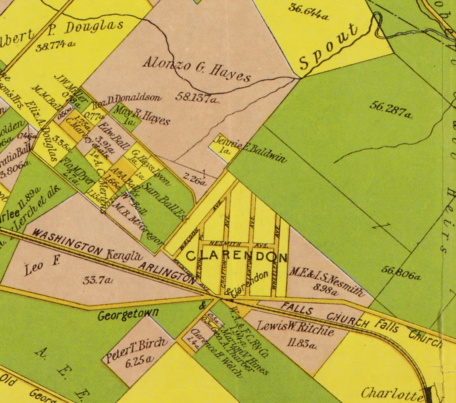
English: This is part of the Howell & Taylor map from 1900 of Arlington, Virginia. Original source: https://www.loc.gov/item/89692758/ |
| Date | |
| Source |
Original publication: 1900 Immediate source: https://www.loc.gov/item/89692758/ |
| Author |
Howell & Taylor for the Virginia Title Company Life time: unknown Other information: English: Rights & Access The maps in the Map Collections materials were either published prior to 1922, produced by the United States government, or both see catalog records that accompany each map for information regarding date of publication and source . The Library of Congress is providing access to these materials for educational and research purposes and is not aware of any U.S. copyright protection see Title 17 of the United States Code or any other restrictions in the Map Collection materials. |
This work is in the public domain in the United States because it was published (or registered with the U.S. Copyright Office) before January 1, 1929.
Public domain works must be out of copyright in both the United States and in the source country of the work in order to be hosted on the Commons. If the work is not a U.S. work, the file must have an additional copyright tag indicating the copyright status in the source country.
Note: This tag should not be used for sound recordings. |
File history
Click on a date/time to view the file as it appeared at that time.
| Date/Time | Thumbnail | Dimensions | User | Comment | |
|---|---|---|---|---|---|
| current | 18:49, 29 March 2014 | | 1,545 × 1,365 (670 KB) | Guusbosman (talk | contribs) | {{subst:Upload marker added by en.wp UW}} {{Information |Description {{en|This is part of the Howell & Taylor map from 1900 of Arlington, Virginia. Original source: http://www.loc.gov/item/89692758/}} |Source Original publication : 1900 br/>... |
You cannot overwrite this file.
File usage on Commons
There are no pages that use this file.
File usage on other wikis
The following other wikis use this file:
- Usage on en.wikipedia.org